world.wikisort.org - South_Africa
De Rust is a small village at the gateway to the Klein Karoo, South Africa. The name is Dutch and literally translates to "The Rest", referring to the town's original purpose of being a resting place for settlers en route through the challenging terrain of a nearby Swartberg gorge.[2]
This article needs additional citations for verification. (July 2011) |
De Rust | |
|---|---|
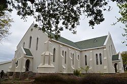
 De Rust Dutch Reformed Church | |
 De Rust  De Rust | |
| Coordinates: 33°28′S 22°31′E | |
| Country | South Africa |
| Province | Western Cape |
| District | Garden Route |
| Municipality | Oudtshoorn |
| Area | |
| • Total | 17.63 km2 (6.81 sq mi) |
| Population (2011)[1] | |
| • Total | 3,566 |
| • Density | 200/km2 (520/sq mi) |
| Racial makeup (2011) | |
| • Black African | 2.5% |
| • Coloured | 87.4% |
| • Indian/Asian | 0.5% |
| • White | 8.9% |
| • Other | 0.8% |
| First languages (2011) | |
| • Afrikaans | 93.6% |
| • English | 4.1% |
| • Other | 2.3% |
| Time zone | UTC+2 (SAST) |
| Postal code (street) | 6651 |
| PO box | 6650 |
| Area code | 044 |
Location
De Rust is located at the foot of the Swartberg Mountain range between Oudtshoorn and Beaufort West.
De Rust is also known for the meandering Meiringspoort pass. Meiringspoort is a gateway that connects the Klein Karoo (little Karoo) and the (great) Karoo through a gorge with a 25 km road crossing the same river 25 times in the span of the 25 km.[3][4] The annual Meiringspoort half marathon runs through the length of the pass and finishes in De Rust.[5]
Climate
| Climate data for De Rust | |||||||||||||
|---|---|---|---|---|---|---|---|---|---|---|---|---|---|
| Month | Jan | Feb | Mar | Apr | May | Jun | Jul | Aug | Sep | Oct | Nov | Dec | Year |
| Average high °C (°F) | 28.3 (82.9) |
28.2 (82.8) |
26.4 (79.5) |
23.4 (74.1) |
20.1 (68.2) |
17.9 (64.2) |
17.4 (63.3) |
18.8 (65.8) |
20.5 (68.9) |
22.7 (72.9) |
24.7 (76.5) |
26.9 (80.4) |
22.9 (73.3) |
| Average low °C (°F) | 13.7 (56.7) |
14.2 (57.6) |
13.0 (55.4) |
10.1 (50.2) |
7.3 (45.1) |
4.8 (40.6) |
3.8 (38.8) |
5.1 (41.2) |
6.6 (43.9) |
8.6 (47.5) |
10.8 (51.4) |
12.2 (54.0) |
9.2 (48.5) |
| Average precipitation mm (inches) | 25 (1.0) |
31 (1.2) |
39 (1.5) |
31 (1.2) |
36 (1.4) |
23 (0.9) |
28 (1.1) |
29 (1.1) |
32 (1.3) |
32 (1.3) |
36 (1.4) |
26 (1.0) |
368 (14.4) |
| Source: Climate-Data.org[6] | |||||||||||||
Farming
This area is also well known for ostrich farming and most of the farmers in the area either farm exclusively with ostriches or as a sideline to their existing farming.
References
- "Main Place De Rust". Census 2011.
- "The Story of De Rust" - De Rust Heritage
- G. Ross: Romance of Cape Mountain Passes. New Africa Books. 2004. ISBN 0864866631, 9780864866639. p.89.
- Meiringspoort Pass
- Meiringspoort 21.1km & 12.5km
- "Climate: De Rust - Climate-Data.org". Retrieved 7 September 2020.
На других языках
[de] De Rust
De Rust (afrikaans, deutsch etwa: „Die Rast“) ist ein Ort in der Gemeinde Oudtshoorn im Distrikt Garden Route, Provinz Westkap in Südafrika. 2011 hatte er 3566 Einwohner.[1] Der Ort liegt am Fuß der Swartberge im Kreuzungsbereich der N12 mit der Route 62. Die nächste Stadt, Oudtshoorn, ist 35 Kilometer und der nächste Flughafen, George, 84 Kilometer entfernt.- [en] De Rust
Другой контент может иметь иную лицензию. Перед использованием материалов сайта WikiSort.org внимательно изучите правила лицензирования конкретных элементов наполнения сайта.
WikiSort.org - проект по пересортировке и дополнению контента Википедии
