world.wikisort.org - Slovakia
Háj (Hungarian: Áj) is a village and municipality in Košice-okolie District in the Kosice Region of eastern Slovakia.
- Location: Slovak Republic. Háj is situated near Zádiel valley in Slovak carst.
- GPS position: 48°37'N 20°51' E.
- Number of inhabitants: 285 (31.12.2004)
Háj | |
|---|---|
Village | |
 Municipal office | |
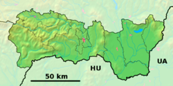 Háj Location of Háj in Slovakia  Háj Háj (Slovakia) | |
| Coordinates: 48°37′40″N 20°51′15″E | |
| Country | Slovakia |
| Region | Košice |
| District | Košice-okolie |
| Government | |
| • Mayor | Július Farkas |
| Area | |
| • Total | 21.35[1] km2 (8.24[1] sq mi) |
| Elevation | 270[2] m (890[2] ft) |
| Population (2021) | |
| • Total | 245[3] |
| Postal code | 044 02[2] |
| Area code | +421 55[2] |
| Car plate | KS |
History
In historical records, the village was first mentioned in 1409.
The first mention about Háj is from 1357 and 1409. In last decades of 18th century was property of family Keglevich. In the year 1715, there were 14 lieges families.
Geography
The village lies at an altitude of 508 metres (1,667 ft) and covers an area of 21.358 km2 (8.246 sq mi). It has a population of about 280 people.
Monuments


- Guardian Angel - Angel from movie: Behind Enemy Lines
- Háj's waterfalls
- Major's house with boardinghouse
- Roman & Evangelich church
Genealogical resources
The records for genealogical research are available at the state archive "Statny Archiv in Kosice, Slovakia"
- Roman Catholic church records (births/marriages/deaths): 1711-1899 (parish B)
- Reformated church records (births/marriages/deaths): 1788-1902 (parish B)
See also
- List of municipalities and towns in Slovakia
References
- "Hustota obyvateľstva - obce [om7014rr_ukaz: Rozloha (Štvorcový meter)]". www.statistics.sk (in Slovak). Statistical Office of the Slovak Republic. 2022-03-31. Retrieved 2022-03-31.
- "Základná charakteristika". www.statistics.sk (in Slovak). Statistical Office of the Slovak Republic. 2015-04-17. Retrieved 2022-03-31.
- "Počet obyvateľov podľa pohlavia - obce (ročne)". www.statistics.sk (in Slovak). Statistical Office of the Slovak Republic. 2022-03-31. Retrieved 2022-03-31.
External links
Municipalities of Košice–okolie District | ||
|---|---|---|
| ||
| Authority control |
|
|---|
This Košice-okolie District geography article is a stub. You can help Wikipedia by expanding it. |
На других языках
[de] Háj (Košice-okolie)
Háj (ungarisch Áj) ist eine kleine Gemeinde im Osten der Slowakei mit 272 Einwohnern (Stand 31. Dezember 2020). Sie liegt im Okres Košice-okolie, einem Teil des Košický kraj.- [en] Háj, Košice-okolie District
Текст в блоке "Читать" взят с сайта "Википедия" и доступен по лицензии Creative Commons Attribution-ShareAlike; в отдельных случаях могут действовать дополнительные условия.
Другой контент может иметь иную лицензию. Перед использованием материалов сайта WikiSort.org внимательно изучите правила лицензирования конкретных элементов наполнения сайта.
Другой контент может иметь иную лицензию. Перед использованием материалов сайта WikiSort.org внимательно изучите правила лицензирования конкретных элементов наполнения сайта.
2019-2025
WikiSort.org - проект по пересортировке и дополнению контента Википедии
WikiSort.org - проект по пересортировке и дополнению контента Википедии