world.wikisort.org - Russia
Butyrsky District (Russian: Бутырский райо́н) is an administrative district (raion) of North-Eastern Administrative Okrug, and one of the 125 raions of Moscow, Russia.[4] It is 6 km north of the Moscow city center, located just outside the third ring road, with Timiryazevsky District to the west and Marfino District and Maryina roshcha District to the east. The area of the district is 5.04 square kilometers (1.95 sq mi).[1] Population: 68,700 (2017 est.).
Butyrsky District
Бутырский район | |
|---|---|
District | |
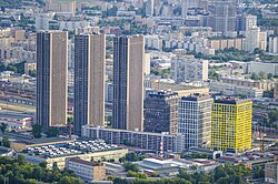
 Savyolovskiy City business center and apartment complex | |
 Flag  Coat of arms | |
 Location of Butyrsky District on the map of Moscow | |
| Coordinates: 55°48′58″N 37°35′9″E | |
| Country | Russia |
| Federal subject | Moscow |
| Area | |
| • Total | 5.04 km2 (1.95 sq mi) |
| Population | |
| • Estimate (2018)[2] | 71,013 |
| Time zone | UTC+3 (MSK |
| OKTMO ID | 45353000 |
| Website | http://butyrsky.mos.ru/ |
History
History first records the village of Butyrka in the 14th century, on the road from Moscow north to Dmitriv (that road is now Butyrskaya Street running up the western border of the district.)[5] The village eventually came into the possession of boyar Nikita Romanovich Zakharin, the grandfather of Tsar Michael I. The farming area gradually developed as a soldier's settlement, then as a fashionable residential area after 1812.[5] After WWII, the area developed with blocks of apartment buildings.
See also
- Administrative divisions of Moscow
References
Notes
- "General Information" (in Russian). Butyrsky District. Retrieved February 5, 2018.
- "26. Численность постоянного населения Российской Федерации по муниципальным образованиям на 1 января 2018 года". Federal State Statistics Service. Retrieved 23 January 2019.
- "Об исчислении времени". Официальный интернет-портал правовой информации (in Russian). 3 June 2011. Retrieved 19 January 2019.
- Государственный комитет Российской Федерации по статистике. Комитет Российской Федерации по стандартизации, метрологии и сертификации. №ОК 019-95 1 января 1997 г. «Общероссийский классификатор объектов административно-территориального деления. Код 45», в ред. изменения №278/2015 от 1 января 2016 г.. (State Statistics Committee of the Russian Federation. Committee of the Russian Federation on Standardization, Metrology, and Certification. #OK 019-95 January 1, 1997 Russian Classification of Objects of Administrative Division (OKATO). Code 45, as amended by the Amendment #278/2015 of January 1, 2016. ).
- "History of the District" (in Russian). Butyrsky District.
{{cite web}}: Missing or empty|url=(help)
Sources
На других языках
- [en] Butyrsky District
[ru] Бутырский район
Буты́рский райо́н — район в Северо-Восточном административном округе города Москвы. Району соответствует внутригородское муниципальное образование муниципальный округ Бутырский. Территория района расположена к северу от Третьего транспортного кольца между железными дорогами Савёловского и Ленинградского направлений. Один из старых районов Москвы (упоминается с 1700 года).Другой контент может иметь иную лицензию. Перед использованием материалов сайта WikiSort.org внимательно изучите правила лицензирования конкретных элементов наполнения сайта.
WikiSort.org - проект по пересортировке и дополнению контента Википедии
