world.wikisort.org - Portugal
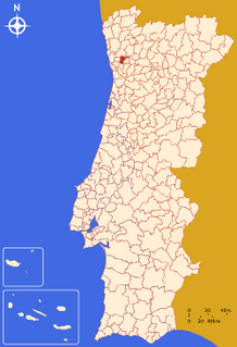
Santo Tirso (Portuguese pronunciation: [ˈsɐ̃tu ˈtiɾsu] (![]() listen)) is a city and municipality located in the north of Porto Metropolitan Area, 25 km from central Porto, Portugal. In the region, the Ave Valley, there is a large center of textile industry. The population in 2011 was 71,530,[1] in an area of 136.60 km².[2]
listen)) is a city and municipality located in the north of Porto Metropolitan Area, 25 km from central Porto, Portugal. In the region, the Ave Valley, there is a large center of textile industry. The population in 2011 was 71,530,[1] in an area of 136.60 km².[2]
Santo Tirso | |
|---|---|
Municipality | |
 Basílica de Nossa Senhora da Assunção | |
 Flag  Coat of arms | |
 | |
| Coordinates: 41°20′N 8°28′W | |
| Country | |
| Region | Norte |
| Metropolitan area | Porto |
| District | Porto |
| Parishes | 14 |
| Government | |
| • President | Alberto Costa (Since 2021) (PS) |
| Area | |
| • Total | 136.60 km2 (52.74 sq mi) |
| Population (2011) | |
| • Total | 71,530 |
| • Density | 520/km2 (1,400/sq mi) |
| Time zone | UTC±00:00 (WET) |
| • Summer (DST) | UTC+01:00 (WEST) |
| Website | http://www.cm-stirso.pt |
Another important center in the municipality is Aves.
The Santo Tirso Monastery built in 978 is a point of interest.
History
The History of Santo Tirso is tied to its benedictine monastery. The town grew around it and, from 978 until 1834, it was a "couto" – a neutral area that belonged to the clergy.[3] Known initially as Santo Tirso de Riba de Ave, this city has been the capital of a municipality at least since 1833.[4] Its composition changed throughout the years, especially in 1998, when the nearby city of Trofa created its own municipality, taking some of Santo Tirso's towns with it.[5]
Towards the middle of the 19th century, Santo Tirso spearheaded the industrialization of the Ave Valley. One of the first textile factories in the region, the Fábrica de Fiação e Tecidos do Rio Vizela, opened in Vila das Aves, part of its municipality, in 1845. This factory would become the largest of its kind in Portugal, with an area of about nine square kilometres and employing, at one point, over 3.000 people.[6]
Geography
The highest point in the municipality is in the Alto de S. Jorge, in the parish of Refojos, with 527 meters of altitude. The municipality's current perimeter is 69 kilometres (43 miles).
Climate
Santo Tirso has a Mediterranean climate with warm to hot summers and mild, very wet winters.
| Climate data for Santo Tirso, 1951–1980, altitude: 28 m (92 ft) | |||||||||||||
|---|---|---|---|---|---|---|---|---|---|---|---|---|---|
| Month | Jan | Feb | Mar | Apr | May | Jun | Jul | Aug | Sep | Oct | Nov | Dec | Year |
| Record high °C (°F) | 23.0 (73.4) |
28.3 (82.9) |
28.0 (82.4) |
31.6 (88.9) |
35.8 (96.4) |
37.7 (99.9) |
40.5 (104.9) |
40.3 (104.5) |
38.7 (101.7) |
33.5 (92.3) |
29.4 (84.9) |
23.8 (74.8) |
40.5 (104.9) |
| Average high °C (°F) | 13.9 (57.0) |
14.6 (58.3) |
16.6 (61.9) |
18.8 (65.8) |
21.5 (70.7) |
24.7 (76.5) |
27.5 (81.5) |
27.4 (81.3) |
25.5 (77.9) |
21.9 (71.4) |
16.9 (62.4) |
14.2 (57.6) |
20.3 (68.5) |
| Daily mean °C (°F) | 9.0 (48.2) |
9.6 (49.3) |
11.4 (52.5) |
13.1 (55.6) |
15.8 (60.4) |
18.7 (65.7) |
20.8 (69.4) |
20.4 (68.7) |
19.0 (66.2) |
15.9 (60.6) |
11.4 (52.5) |
9.2 (48.6) |
14.5 (58.1) |
| Average low °C (°F) | 4.1 (39.4) |
4.6 (40.3) |
6.2 (43.2) |
7.4 (45.3) |
10.1 (50.2) |
12.7 (54.9) |
14.1 (57.4) |
13.4 (56.1) |
12.5 (54.5) |
9.9 (49.8) |
5.9 (42.6) |
4.2 (39.6) |
8.8 (47.8) |
| Average rainfall mm (inches) | 193.4 (7.61) |
187.6 (7.39) |
169.0 (6.65) |
96.3 (3.79) |
95.6 (3.76) |
56.2 (2.21) |
22.7 (0.89) |
25.0 (0.98) |
64.1 (2.52) |
128.1 (5.04) |
154.8 (6.09) |
181.4 (7.14) |
1,374.2 (54.07) |
| Average relative humidity (%) | 86 | 82 | 77 | 71 | 71 | 71 | 68 | 71 | 76 | 82 | 86 | 87 | 77 |
| Source: Instituto de Meteorologia[7] | |||||||||||||
Parishes

Administratively, the municipality is divided into 14 civil parishes (freguesias):[8]
Sports
Santo Tirso is home of the historic[further explanation needed] football club Futebol Clube Tirsense and C.D. Aves.
Notable people
- Luís Gonzaga Ferreira da Silva (1923–2013) a Prelate of the Catholic Church & bishop of the Diocese of Lichinga
- Sofia Andrade (born 1988) a Portuguese politician
Sport

- Alberto Festa (born 1939) a retired footballer with 143 club caps and 19 for Portugal
- José Pacheco (born 1942) a former cyclist, competed at the 1960 Summer Olympics
- Quim Machado (born 1966) a former footballer with 320 club caps a current manager.
- Gaspar Azevedo (born 1975) known as Gaspar, a retired footballer with 429 club caps
- Ricardo Rocha (born 1978) a retired footballer with 362 club caps and 6 for Portugal
- Pedro Moutinho (born 1979) a retired footballer with 343 club caps
- Orlando Neto (born 1979), known as Orlando, a former footballer with 386 club caps
- Rui Pedro Silva (born 1981) a track and field, long distance and cross country athlete, competed at the 2008 & 2012 Summer Olympics
- Sara Moreira (born 1985) a cross country, road, middle & long distance track runner.
References
- Instituto Nacional de Estatística
- Eurostat
- "Santo Tirso - Infopédia".
- "História | C.M. Santo Tirso".
- Município da Trofa – História
- "Fábrica de Fiação e Tecidos do Rio Vizela Arquivos - Revista Pontos de Vista".
- "Plano Municipal de Defesa da Floresta Contra Incêndios" (PDF). Trofa Municipality. Retrieved 9 July 2021.
- Diário da República. "Law nr. 11-A/2013, page 552 109" (PDF) (in Portuguese). Retrieved 30 July 2014.
- Diário da República. "Law nr. 86/2015, page 5671" (PDF) (in Portuguese). Retrieved 20 May 2022.
External links
| Wikimedia Commons has media related to Santo Tirso. |
На других языках
[de] Santo Tirso
Santo Tirso ist eine Gemeinde und Stadt im Norden Portugals, die sehr vom Weinbau geprägt ist. In der Gemeinde leben 14.072 Einwohner (Stand 30. Juni 2011)[1].- [en] Santo Tirso
[es] Santo Tirso
Santo Tirso es una ciudad portuguesa perteneciente al distrito de Oporto, Región estadística del Norte (NUTS II) y la comunidad intermunicipal Gran Área Metropolitana de Oporto (NUTS III) con cerca de 14 000 habitantes. Recientemente forma parte de la Gran Área Metropolitana de Oporto que unió las anteriores áreas de Grande Porto y Entre Douro e Vouga.[ru] Санту-Тирсу
Са́нту-Ти́рсу (порт. Santo Tirso ['sɐ̃tu 'tiɾsu]) — город в Португалии, центр одноимённого муниципалитета в составе округа Порту. Находится в составе крупной городской агломерации Большой Порту. По старому административному делению входил в провинцию Дору-Литорал. Входит в экономико-статистический субрегион Аве, который входит в Северный регион. Численность населения — 14 тыс. жителей (город), 72,4 тыс. жителей (муниципалитет) на 2001 год. Занимает площадь 135,31 км².Другой контент может иметь иную лицензию. Перед использованием материалов сайта WikiSort.org внимательно изучите правила лицензирования конкретных элементов наполнения сайта.
WikiSort.org - проект по пересортировке и дополнению контента Википедии