world.wikisort.org - Portugal
Santana (Portuguese pronunciation: [sɐ̃ˈtɐnɐ] (![]() listen)), short form for Santa Ana (meaning Saint Anne) is a municipality along the northern coast of the island of Madeira, in the Portuguese archipelago of the same name. The population in 2011 was 7,719,[1] in an area of 95.56 square kilometres (36.90 sq mi).[2]
listen)), short form for Santa Ana (meaning Saint Anne) is a municipality along the northern coast of the island of Madeira, in the Portuguese archipelago of the same name. The population in 2011 was 7,719,[1] in an area of 95.56 square kilometres (36.90 sq mi).[2]
Santana | |
|---|---|
Municipality | |
 The village of Arco de São Jorge in an amphitheatre-shapped valley along the northern coast of Santana municipality | |
 Flag  Coat of arms | |
 Location in Madeira | |
| Coordinates: 32°48′13.45″N 16°52′47.30″W | |
| Country | |
| Auton. region | Madeira |
| Island | Madeira |
| Established | Settlement: 25 May 1835 City: 6 July 2000 |
| Parishes | 6 |
| Government | |
| • President | António Joaquim Caíres Batista Rosa |
| Area | |
| • Total | 95.56 km2 (36.90 sq mi) |
| Elevation | 509 m (1,670 ft) |
| Population (2021) | |
| • Total | 6,558 |
| • Density | 69/km2 (180/sq mi) |
| Time zone | UTC±00:00 (WET) |
| • Summer (DST) | UTC+01:00 (WEST) |
| Postal code | 9230-116 |
| Area code | 291 |
| Patron | Saint Anne |
| Local holiday | 24 June |
| Website | http://cm-santana.com |
Geography
Santana includes six parishes, within a rugged mountainous environment, most occupying river-valleys:
- Arco de São Jorge
- Faial
- Ilha
- Santana - the parish (and town) has a population of 3,275 (in 2011), in an area of 19.01 km²
- São Jorge
- São Roque do Faial
Santana parish has the largest number residents, while Arco de São Jorge is both the smallest, physically, and has the lowest number of residents,[3] while Faial is the largest parish.
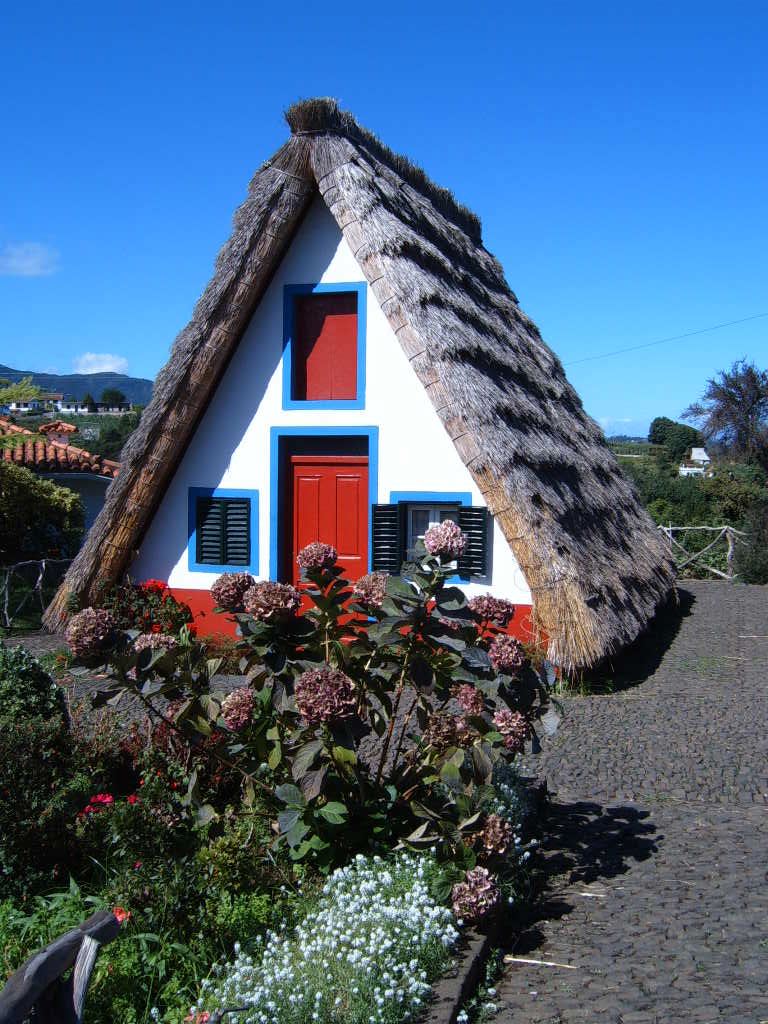
Santana is known for the traditional homes constructed with sloping triangular rooftops, and protected with straw. These were mainly rural homes, used by local farmers, during the settlement of the island, with white-painted walls, red doors and windows with blue trim. Most of the surviving buildings are tourist attractions, and maintained (for example, the straw roofs are replaced every four to five years).
Economy
A tourist-themed park was constructed to exhibit examples of the island's early history and culture; the Madeira Theme Park is an ample area, on 7 acres (28,000 m2) of land, where visitors re-discover the cultures of Madeira and Porto Santo. This includes exhibits on the island's history, artifacts used in daily life and cultural presentations, in a scenic environment.
Notable citizens
- Teodósio de Gouveia (1889 in São Jorge - 1962 in Lourenço Marques) - Roman Catholic Cardinal for Lourenço Marques, and first resident Cardinal in Africa.
References
- Instituto Nacional de Estatística
- Eurostat
- Santana and Arco de São Jorge are also located in the higher altitudes in the municipality.
| Madeira Island |
| |
|---|---|---|
| Porto Santo Island |
| |
На других языках
- [en] Santana, Madeira
[ru] Сантана (Мадейра)
Санта́на (порт. Santana) — город на востоке острова Мадейры, что в Автономном регионе Мадейры (Португалия), с населением 3439 человек (2001). Является административным центром одноименного района (муниципалитета) с площадью 93,10 км² и населением 8804 человек (2001)[1], который граничит на западе с муниципалитетом Сан-Висенти, на севере — омывается Атлантическим океаном, на востоке граничит с муниципалитетом Машику, на юге — с муниципалитетами Санта-Круш и Фуншала, и на юго-западе — Рибейра-Брава.Другой контент может иметь иную лицензию. Перед использованием материалов сайта WikiSort.org внимательно изучите правила лицензирования конкретных элементов наполнения сайта.
WikiSort.org - проект по пересортировке и дополнению контента Википедии