world.wikisort.org - Portugal
Ponta do Sol (Portuguese pronunciation: [ˈpõtɐ ðu ˈsɔl] (![]() listen); English: "Cape of the Sun") is a municipality in the southwestern coast of the island of Madeira, in the archipelago of Madeira. The population in 2011 was 8,862,[1] in an area of 46.19 km2 (17.83 sq mi).[2]
listen); English: "Cape of the Sun") is a municipality in the southwestern coast of the island of Madeira, in the archipelago of Madeira. The population in 2011 was 8,862,[1] in an area of 46.19 km2 (17.83 sq mi).[2]
Ponta do Sol | |
|---|---|
Municipality | |
 The seafront of Ponta do Sol | |
 Flag  Coat of arms | |
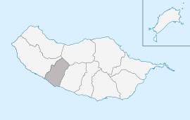 Location in Madeira | |
| Coordinates: 32°40′50″N 17°6′15″W | |
| Country | |
| Auton. region | Madeira |
| Island | Madeira |
| Established | Settlement: c. 1420 Municipality: 2 December 1501 |
| Parishes | 3 |
| Government | |
| • President | Celia Marques Luís |
| Area | |
| • Total | 46.19 km2 (17.83 sq mi) |
| Elevation | 34 m (112 ft) |
| Population (2011) | |
| • Total | 8,862 |
| • Density | 190/km2 (500/sq mi) |
| Time zone | UTC±00:00 (WET) |
| • Summer (DST) | UTC+01:00 (WEST) |
| Postal code | 9360-219 |
| Area code | 291 |
| Website | pontadosol.pt |
History
The settlement of Ponta do Sol began shortly after the discovery of the island of Madeira, around 1420.
Geography


Ponta do Sol is located between Ribeira-Brava and Calheta, on the southwest coast of Madeira, linked to Funchal (the capital) and surrounding communities by the main regional road.
The municipality is crossed by a few pedestrian hiking trails, that usually follow the levadas (English: aqueducts) carrying water from the mountains.
Human geography
Administratively, the municipal government is located in the civil parish (freguesia) of Ponta do Sol, while local government is handled through the three civil parishes:
- Canhas
- Madalena do Mar
- Ponta do Sol - in 2011, the parish had a population of 4,577 inhabitants, in an area of 27.45 km2 (10.60 sq mi)
Economy
Historically, the main sources of income in this region has been agriculture, fishing and trade. Ponta do Sol's main harbour, although small, was a crucial commercial gateway to the western part of the island. These importation and exportation businesses fostered the creation of new activities in what became the central part of the community and created a flow of goods into the hinterland (such as local and imported goods).
Today, commercial activity is scattered throughout the municipality, while the port area of Ponta do Sol has declined in importance. In its place, the economy of the municipality has been dispersed to other parishes, particularly Canhas, which were essentially agricultural parishes, but have developed into important economic nodes, while still retaining its rural landscape. While agriculture remains the primary activity in the interior, and the fisheries industry has declined significantly, construction and industrial enterprises have conquered a prominent role in the municipality. The service industry, particularly tourism, has carved-out a portion of the income stream, with high-quality hotels or residential inns located in the countryside and urban centres.
References
External links
 Media related to Ponta do Sol at Wikimedia Commons
- Photos of Ponta do Sol
| Madeira Island |
| |
|---|---|---|
| Porto Santo Island |
| |
Authority control | |
|---|---|
| General |
|
| National libraries | |
На других языках
- [en] Ponta do Sol, Madeira
[ru] Понта-ду-Сол
По́нта-ду-Со́л (порт. Ponta do Sol) — посёлок на юго-западе острова Мадейры, в автономном регионе Мадейры (Португалия), с населением 4224 человек (2001). Является административным центром одноименного района (муниципалитета) с площадью 43,80 км² и населением 8125 человек (2001)[1], который на юге омывается Атлантическим океаном, на западе граничит с муниципалитетом Кальеты, на северо-западе — с муниципалитетом Порту-Мониш, на севере — с муниципалитетом Сан-Висенти и на востоке — Рибейра-Брава. Расстояние до столицы острова города Фуншала составляет 18 км.Другой контент может иметь иную лицензию. Перед использованием материалов сайта WikiSort.org внимательно изучите правила лицензирования конкретных элементов наполнения сайта.
WikiSort.org - проект по пересортировке и дополнению контента Википедии