world.wikisort.org - Philippines
Tangalan, officially the Municipality of Tangalan (Aklanon: Banwa it Tangalan; Hiligaynon: Banwa sang Tangalan; Tagalog: Bayan ng Tangalan), is a 5th class municipality in the province of Aklan, Philippines. According to the 2020 census, it has a population of 23,704 people. [3]
Tangalan | |
|---|---|
Municipality | |
| Municipality of Tangalan | |
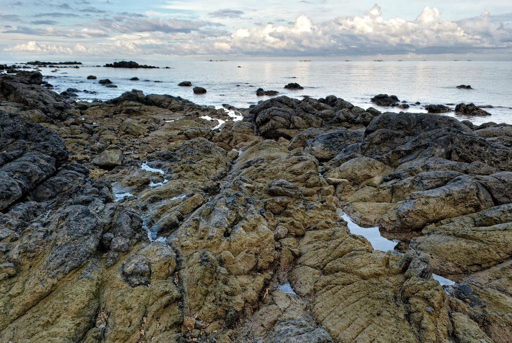 Tangalan seascape | |
 Flag  Seal | |
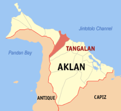 Map of Aklan with Tangalan highlighted | |
OpenStreetMap  | |
 Tangalan Location within the Philippines | |
| Coordinates: 11°46′39″N 122°15′37″E | |
| Country | Philippines |
| Region | Western Visayas |
| Province | Aklan |
| District | 2nd district |
| Barangays | 15 (see Barangays) |
| Government | |
| • Type | Sangguniang Bayan |
| • Mayor | Gary T. Fuentes |
| • Vice Mayor | Gene T. Fuentes |
| • Representative | Teodorico T. Haresco Jr. |
| • Municipal Council | Members |
| • Electorate | 14,399 voters (2019) |
| Area | |
| • Total | 74.59 km2 (28.80 sq mi) |
| Elevation | 39 m (128 ft) |
| Highest elevation | 876 m (2,874 ft) |
| Lowest elevation | 0 m (0 ft) |
| Population | |
| • Total | 23,704 |
| • Density | 320/km2 (820/sq mi) |
| • Households | 4,920 |
| Economy | |
| • Income class | 5th municipal income class |
| • Poverty incidence | 15.31% (2018)[4] |
| • Revenue | ₱104,716,829.51 (2020) |
| • Assets | ₱282,592,525.11 (2020) |
| • Expenditure | ₱78,548,840.11 (2020) |
| • Liabilities | ₱38,249,234.45 (2020) |
| Service provider | |
| • Electricity | Aklan Electric Cooperative (AKELCO) |
| Time zone | UTC+8 (PST) |
| ZIP code | 5612 |
| PSGC | |
| IDD : area code | +63 (0)36 |
| Native languages | Aklan Hiligaynon Tagalog |
| Website | www |
Tangalan was formerly an arrabal of Makato. At the time of its creation, it included the following barrios: Tondog, Jawili, Dumatad, Afga, Baybay, Dapdap, Pudyot, Tagas, Tamalagon, Panayakan, Vivo, Lanipga, Napatag and Tamokoe.[5]
Geography
Tangalan is located at 11°46′39″N 122°15′37″E. It is 18 kilometres (11 mi) from Kalibo, the provincial capital.
According to the Philippine Statistics Authority, the municipality has a land area of 74.59 square kilometres (28.80 sq mi) [6] constituting 4.10% of the 1,821.42-square-kilometre- (703.25 sq mi) total area of Aklan.
Climate
| Climate data for Tangalan, Aklan | |||||||||||||
|---|---|---|---|---|---|---|---|---|---|---|---|---|---|
| Month | Jan | Feb | Mar | Apr | May | Jun | Jul | Aug | Sep | Oct | Nov | Dec | Year |
| Average high °C (°F) | 28 (82) |
29 (84) |
30 (86) |
32 (90) |
32 (90) |
31 (88) |
30 (86) |
29 (84) |
29 (84) |
29 (84) |
29 (84) |
28 (82) |
30 (85) |
| Average low °C (°F) | 23 (73) |
23 (73) |
23 (73) |
24 (75) |
25 (77) |
25 (77) |
25 (77) |
24 (75) |
24 (75) |
24 (75) |
24 (75) |
23 (73) |
24 (75) |
| Average precipitation mm (inches) | 47 (1.9) |
33 (1.3) |
39 (1.5) |
48 (1.9) |
98 (3.9) |
150 (5.9) |
169 (6.7) |
147 (5.8) |
163 (6.4) |
172 (6.8) |
118 (4.6) |
80 (3.1) |
1,264 (49.8) |
| Average rainy days | 11.4 | 8.2 | 9.3 | 9.7 | 19.1 | 25.6 | 27.4 | 25.5 | 25.5 | 25.2 | 18.5 | 14.5 | 219.9 |
| Source: Meteoblue[7] | |||||||||||||
Barangays
Tangalan is politically subdivided into 15 barangays.[8]
| PSGC | Barangay | Population | ±% p.a. | |||
|---|---|---|---|---|---|---|
| 2020 [3] | 2010 [9] | |||||
| 060417001 | Afga | 6.8% | 1,612 | 1,472 | 0.87% | |
| 060417002 | Baybay | 6.7% | 1,597 | 1,582 | 0.09% | |
| 060417003 | Dapdap | 4.4% | 1,042 | 966 | 0.73% | |
| 060417004 | Dumatad | 4.8% | 1,130 | 1,051 | 0.70% | |
| 060417005 | Jawili | 7.7% | 1,822 | 1,732 | 0.49% | |
| 060417006 | Lanipga | 1.4% | 330 | 312 | 0.54% | |
| 060417007 | Napatag | 0.9% | 224 | 280 | −2.11% | |
| 060417008 | Panayakan | 13.1% | 3,116 | 2,684 | 1.44% | |
| 060417009 | Poblacion | 6.4% | 1,516 | 1,429 | 0.57% | |
| 060417010 | Pudiot | 7.7% | 1,828 | 1,617 | 1.18% | |
| 060417011 | Tagas | 10.2% | 2,407 | 2,017 | 1.71% | |
| 060417012 | Tamalagon | 11.0% | 2,609 | 2,497 | 0.42% | |
| 060417013 | Tamokoe | 0.6% | 154 | 228 | −3.69% | |
| 060417014 | Tondog | 8.2% | 1,955 | 1,745 | 1.09% | |
| 060417015 | Vivo | 2.4% | 574 | 665 | −1.40% | |
| Total | 23,704 | 20,277 | 1.51% | |||
Demographics
| Year | Pop. | ±% p.a. |
|---|---|---|
| 1903 | 3,009 | — |
| 1948 | 6,765 | +1.82% |
| 1960 | 7,650 | +1.03% |
| 1970 | 9,987 | +2.70% |
| 1975 | 10,509 | +1.03% |
| 1980 | 11,174 | +1.23% |
| 1990 | 14,773 | +2.83% |
| 1995 | 16,172 | +1.71% |
| 2000 | 17,606 | +1.84% |
| 2007 | 19,121 | +1.15% |
| 2010 | 20,277 | +2.16% |
| 2015 | 21,916 | +1.49% |
| 2020 | 23,704 | +1.55% |
| Source: Philippine Statistics Authority [10] [9] [11][12] | ||
In the 2020 census, Tangalan had a population of 23,704. [3] The population density was 320 inhabitants per square kilometre (830/sq mi).
Economy
Tourism

Tourist spots with government support under "Project Bugna" include Jawili Falls, Jawili Beach Resorts, Dumatad Souvenir Shop, and Bughawi Reforestation Project.
The Tangalan Marine Sanctuary covers 375 hectares (930 acres) of marine ecosystem and a 10 hectares (25 acres) coral garden.
References
- Municipality of Tangalan | (DILG)
- "2015 Census of Population, Report No. 3 – Population, Land Area, and Population Density" (PDF). Philippine Statistics Authority. Quezon City, Philippines. August 2016. ISSN 0117-1453. Archived (PDF) from the original on May 25, 2021. Retrieved July 16, 2021.
- Census of Population (2020). "Region VI (Western Visayas)". Total Population by Province, City, Municipality and Barangay. PSA. Retrieved 8 July 2021.
- "PSA Releases the 2018 Municipal and City Level Poverty Estimates". Philippine Statistics Authority. 15 December 2021. Retrieved 22 January 2022.
- "Republic Act No. 285; An Act Creating the Municipality of Tangalan in the Province of Capiz". The Corpus Juris. 16 June 1948. Retrieved 22 October 2016.
- "Province: Aklan". PSGC Interactive. Quezon City, Philippines: Philippine Statistics Authority. Retrieved 12 November 2016.
- "Tangalan: Average Temperatures and Rainfall". Meteoblue. Retrieved 1 May 2020.
- "Municipal: Tangalan". PSGC Interactive. Quezon City, Philippines: Philippine Statistics Authority. Retrieved 8 January 2016.
- Census of Population and Housing (2010). "Region VI (Western Visayas)". Total Population by Province, City, Municipality and Barangay. NSO. Retrieved 29 June 2016.
- Census of Population (2015). "Region VI (Western Visayas)". Total Population by Province, City, Municipality and Barangay. PSA. Retrieved 20 June 2016.
- Censuses of Population (1903–2007). "Region VI (Western Visayas)". Table 1. Population Enumerated in Various Censuses by Province/Highly Urbanized City: 1903 to 2007. NSO.
- "Province of Aklan". Municipality Population Data. Local Water Utilities Administration Research Division. Retrieved 17 December 2016.
- "Poverty incidence (PI):". Philippine Statistics Authority. Retrieved 28 December 2020.
- https://psa.gov.ph/sites/default/files/NSCB_LocalPovertyPhilippines_0.pdf; publication date: 29 November 2005; publisher: Philippine Statistics Authority.
- https://psa.gov.ph/sites/default/files/2003%20SAE%20of%20poverty%20%28Full%20Report%29_1.pdf; publication date: 23 March 2009; publisher: Philippine Statistics Authority.
- https://psa.gov.ph/sites/default/files/2006%20and%202009%20City%20and%20Municipal%20Level%20Poverty%20Estimates_0_1.pdf; publication date: 3 August 2012; publisher: Philippine Statistics Authority.
- https://psa.gov.ph/sites/default/files/2012%20Municipal%20and%20City%20Level%20Poverty%20Estima7tes%20Publication%20%281%29.pdf; publication date: 31 May 2016; publisher: Philippine Statistics Authority.
- https://psa.gov.ph/sites/default/files/City%20and%20Municipal-level%20Small%20Area%20Poverty%20Estimates_%202009%2C%202012%20and%202015_0.xlsx; publication date: 10 July 2019; publisher: Philippine Statistics Authority.
- "PSA Releases the 2018 Municipal and City Level Poverty Estimates". Philippine Statistics Authority. 15 December 2021. Retrieved 22 January 2022.
External links
Places adjacent to Tangalan | ||||||||||||||||
|---|---|---|---|---|---|---|---|---|---|---|---|---|---|---|---|---|
| ||||||||||||||||
Kalibo (capital) | |
| Municipalities | |
На других языках
[de] Tangalan
Tangalan ist eine philippinische Stadtgemeinde in der Provinz Aklan. Sie hat 21.916 Einwohner (Zensus 1. August 2015).- [en] Tangalan
Другой контент может иметь иную лицензию. Перед использованием материалов сайта WikiSort.org внимательно изучите правила лицензирования конкретных элементов наполнения сайта.
WikiSort.org - проект по пересортировке и дополнению контента Википедии