world.wikisort.org - Philippines
The Port Area is a district of the city of Manila, Philippines. It is entirely a reclaimed land occupied by Manila South Harbor and Baseco Compound. It is bounded on the north by Pasig River, facing the districts of Tondo and San Nicolas, on the west by Manila Bay, on the east by Intramuros, separated by Radial Road 1, and on the south by Ermita. Post-war developments at the Manila South Harbor eventually paved the way for the migration of people from the different provinces, making it one of the largest urban poor community in the Philippines.
This article needs additional citations for verification. (December 2020) |
Port Area | |
|---|---|
District of Manila | |
 Aerial view of Port Area with Customs House | |
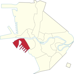 Map of Manila showing the location of Port Area | |
 | |
| Coordinates: 14.588726°N 120.968597°E | |
| Country | Philippines |
| Region | National Capital Region |
| City | Manila |
| District | Part of the 5th district of Manila |
| Population (2020)[1] | |
| • Total | 72,605 |
Barangays
The district of Port Area is made up of 5 barangays, numbered 649, 650, 651, 652 and 653. Barangay 649 contains the Engineer's Island, now informally known as the Baseco Compound. The Island is regarded as one of the biggest urban poor community in the Philippines. All barangays of Port Area (barangays 649 to 653) belongs to Zone 68 of the City of Manila.
| Barangay | Population (2020)[1] |
|---|---|
| Barangay 649 | 64,750 |
| Barangay 650 | 5,202 |
| Barangay 651 | 2,556 |
| Barangay 652 | 39 |
| Barangay 653 | 58 |
References
- "Highlights of the Philippine Population 2015 Census of Population". Philippine Statistics Authority. Retrieved July 11, 2017.
External links
 Media related to Port Area, Manila at Wikimedia Commons
 Geographic data related to Port Area, Manila at OpenStreetMap
City of Manila | ||
|---|---|---|
Capital of the Philippines | ||
| Topics |
|  |
| Government |
| |
| Districts | ||
| Mixed-use developments |
| |
| Beaches |
| |
| Legislative districts |
| |
| ||
Cities and municipalities | |||||||||||
| |||||||||||
| |||||||||||
| |||||||||||
See also: Administrative divisions of Metro Manila | |||||||||||
Другой контент может иметь иную лицензию. Перед использованием материалов сайта WikiSort.org внимательно изучите правила лицензирования конкретных элементов наполнения сайта.
WikiSort.org - проект по пересортировке и дополнению контента Википедии