world.wikisort.org - Philippines
Orani, officially the Municipality of Orani (Tagalog: Bayan ng Orani), is a 1st class municipality in the province of Bataan, Philippines. According to the 2020 census, it has a population of 70,342 people. [3]
Orani | |
|---|---|
Municipality | |
| Municipality of Orani | |
 | |
 Seal | |
 Map of Bataan with Orani highlighted | |
OpenStreetMap  | |
 Orani Location within the Philippines | |
| Coordinates: 14°48′N 120°32′E | |
| Country | Philippines |
| Region | Central Luzon |
| Province | Bataan |
| District | 1st district |
| Founded | 1891 |
| Barangays | 29 (see Barangays) |
| Government | |
| • Type | Sangguniang Bayan |
| • Mayor | Efren Dominic E. Pascual Jr. |
| • Vice Mayor | Emmanuel R. Roman |
| • Representative | Geraldine B. Roman |
| • Municipal Council | Members |
| • Electorate | 48,916 voters (2022) |
| Area | |
| • Total | 64.90 km2 (25.06 sq mi) |
| Elevation | 14 m (46 ft) |
| Highest elevation | 117 m (384 ft) |
| Lowest elevation | −4 m (−13 ft) |
| Population | |
| • Total | 70,342 |
| • Density | 1,100/km2 (2,800/sq mi) |
| • Households | 17,524 |
| Economy | |
| • Income class | 1st municipal income class |
| • Poverty incidence | 6.66% (2018)[4] |
| • Revenue | ₱273,773,378.58 (2020) |
| • Assets | ₱526,529,874.36 (2020) |
| • Expenditure | ₱290,920,814.85 (2020) |
| • Liabilities | ₱274,878,431.20 (2020) |
| Service provider | |
| • Electricity | Peninsula Electric Cooperative (PENELCO) |
| Time zone | UTC+8 (PST) |
| ZIP code | 2108 |
| PSGC | |
| IDD : area code | +63 (0)47 |
| Native languages | Mariveleño Kapampangan Tagalog |
Geography
Orani is 14 kilometres (8.7 mi) from Balanga and 110 kilometres (68 mi) north-west of Manila and accessible via the Bataan Provincial Expressway, off Exit 20. It is bounded on the north by Hermosa, south by Samal, west by Dinalupihan and east by the Manila Bay. It has a total land area of 64.90 square kilometres (25.06 sq mi) covering 29 barangays. About 1,231 hectares (3,040 acres) are used for agriculture, 1,943.86 hectares (4,803.4 acres) are forestland, 971.93 hectares (2,401.7 acres) are forest reservation and 1,295.9 hectares (3,202 acres) are reserved for the National Park. The rest are classified as wetland.
According to the Philippine Statistics Authority, the municipality has a land area of 64.90 square kilometres (25.06 sq mi) [5] constituting 4.73% of the 1,372.98-square-kilometre- (530.11 sq mi) total area of Bataan.
Climate
| Climate data for Orani, Bataan | |||||||||||||
|---|---|---|---|---|---|---|---|---|---|---|---|---|---|
| Month | Jan | Feb | Mar | Apr | May | Jun | Jul | Aug | Sep | Oct | Nov | Dec | Year |
| Average high °C (°F) | 31 (88) |
32 (90) |
34 (93) |
35 (95) |
33 (91) |
31 (88) |
29 (84) |
29 (84) |
29 (84) |
29 (84) |
30 (86) |
31 (88) |
31 (88) |
| Average low °C (°F) | 19 (66) |
19 (66) |
20 (68) |
23 (73) |
25 (77) |
25 (77) |
24 (75) |
25 (77) |
25 (77) |
24 (75) |
23 (73) |
20 (68) |
23 (73) |
| Average precipitation mm (inches) | 7 (0.3) |
8 (0.3) |
14 (0.6) |
26 (1.0) |
127 (5.0) |
210 (8.3) |
263 (10.4) |
272 (10.7) |
218 (8.6) |
114 (4.5) |
46 (1.8) |
21 (0.8) |
1,326 (52.3) |
| Average rainy days | 4.0 | 4.0 | 6.9 | 11.2 | 21.0 | 24.5 | 27.4 | 26.9 | 25.9 | 21.9 | 13.4 | 6.3 | 193.4 |
| Source: Meteoblue (modeled/calculated data, not measured locally)[6] | |||||||||||||
Barangays
Orani is politically subdivided into 29 barangays.[7]
| PSGC | Barangay | Population | ±% p.a. | |||
|---|---|---|---|---|---|---|
| 2020 [3] | 2010 [8] | |||||
| 030809025 | Apollo | 2.8% | 1,955 | 1,857 | 0.49% | |
| 030809001 | Bagong Paraiso (Poblacion) | 4.0% | 2,835 | 2,276 | 2.10% | |
| 030809002 | Balut (Poblacion) | 1.9% | 1,355 | 1,397 | −0.29% | |
| 030809003 | Bayan (Poblacion) | 8.6% | 6,018 | 5,363 | 1.10% | |
| 030809004 | Calero (Poblacion) | 2.0% | 1,438 | 1,686 | −1.50% | |
| 030809016 | Centro I (Poblacion) | 0.7% | 501 | 404 | 2.06% | |
| 030809006 | Centro II (Poblacion) | 0.6% | 431 | 400 | 0.71% | |
| 030809007 | Dona | 1.8% | 1,249 | 1,213 | 0.28% | |
| 030809026 | Kabalutan | 3.5% | 2,462 | 2,099 | 1.52% | |
| 030809008 | Kaparangan | 4.3% | 3,021 | 3,123 | −0.31% | |
| 030809027 | Maria Fe | 3.1% | 2,146 | 2,046 | 0.45% | |
| 030809009 | Masantol | 1.0% | 690 | 736 | −0.61% | |
| 030809010 | Mulawin | 6.2% | 4,380 | 3,534 | 2.05% | |
| 030809011 | Pag‑asa | 3.5% | 2,486 | 1,927 | 2.44% | |
| 030809005 | Paking‑Carbonero (Poblacion) | 1.7% | 1,164 | 1,272 | −0.84% | |
| 030809012 | Palihan (Poblacion) | 3.7% | 2,581 | 2,452 | 0.49% | |
| 030809013 | Pantalan Bago (Poblacion) | 3.2% | 2,250 | 2,130 | 0.52% | |
| 030809014 | Pantalan Luma (Poblacion) | 7.9% | 5,563 | 5,026 | 0.97% | |
| 030809015 | Parang Parang (Poblacion) | 2.0% | 1,407 | 1,265 | 1.01% | |
| 030809028 | Puksuan | 0.9% | 645 | 661 | −0.23% | |
| 030809017 | Sibul | 1.8% | 1,283 | 1,084 | 1.61% | |
| 030809018 | Silahis | 0.7% | 510 | 484 | 0.50% | |
| 030809029 | Tagumpay | 2.8% | 2,003 | 1,833 | 0.84% | |
| 030809019 | Tala | 2.1% | 1,467 | 1,337 | 0.88% | |
| 030809020 | Talimundoc | 3.5% | 2,493 | 2,135 | 1.48% | |
| 030809021 | Tapulao | 7.1% | 5,023 | 4,745 | 0.54% | |
| 030809022 | Tenejero (Poblacion) | 2.8% | 1,968 | 1,706 | 1.36% | |
| 030809023 | Tugatog | 9.7% | 6,856 | 6,145 | 1.04% | |
| 030809024 | Wawa (Poblacion) | 1.0% | 729 | 763 | −0.43% | |
| Total | 70,342 | 61,099 | 1.34% | |||
Demographics
|
| |||||||||||||||||||||||||||||||||||||||||||||||||||
| Source: Philippine Statistics Authority [9] [8] [10][11] | ||||||||||||||||||||||||||||||||||||||||||||||||||||
In the 2020 census, Orani had a population of 70,342. [3] The population density was 1,100 inhabitants per square kilometre (2,800/sq mi).
Economy
Palay, coffee, vegetables, peanut, citrus trees and fruit trees are the major produce. Cutflowers like aster, chrysanthemum and gerbera are locally cultivated while bamboo and jungle vines can be gathered from Orani's forestlands. Aquamarine resources like milkfish, tilapia, prawn, crabs, mussels and oysters are caught in Orani's fishing grounds and fishponds.
Government

Pursuant to the Local government in the Philippines",[19][20] the political seat of the municipal government is located at the Municipal Hall. In the History of the Philippines (1521–1898), the Gobernadorcillo was the Chief Executive who held office in the Presidencia. During the American rule (1898–1946) (History of the Philippines (1898-1946)), the elected Mayor and local officials, including the appointed ones held office at the Municipal Hall. The legislative and executive departments perform their functions in the Sangguniang Bayan (Session Hall) and Municipal Trial Court, respectively, and are located in the Town Hall.
Orani, Bataan's incumbent elected officials are - Mayor Efren Dominic E. Pascual, Jr. and Vice Mayor Emmanuel Bati Roman., including 8 Councilors or Sanguniang Bayan Members:[21][22] Jose Gener Quiambao Pascual, Maria Abba Narciso Sicat, Francis Sevilla Dela Torre, Jun Anthony Ignacio Reyes, Mayfair Bongco Sibug, Bonifacio Francisco Cruz Jr. ,Renato Rodriguez Bugay, Miguel Salonga Paredes. They hold office at the second floor of the Town Hall, particularly the Office of the Mayor and Sangguniang Bayan Session Hall, respectively.
The 2nd Municipal Circuit Trial Court of Orani-Samal, MCTC Judge Ma. Cristina J. Mendoza-Pizzaro holds office in her sala located at the second floor of the MTC building at the back of the Town hall.
The municipality passed an ordinance that protects its people against discrimination based on disability, age, civil status, health status, ethnicity, religion, sexual orientation, gender identity, and expression in January 2019 - becoming the first Bataan local government unit to do so.[23]
Tourism

Orani's attractions, events and historical landmarks include:[24]
- Orani People's Park, center of Poblacion, Plaza
- The 1714 Orani Church, commonly known as the "Our Lady of the Most Holy Rosary Parish Church of Orani" ("Our Lady of the Rosary of Orani", "Nuestra Señora del Rosario Parish Church", "Church of Orani" or "Virgen Milagrosa Del Rosario del Pueblo de Orani Shrine") is a Neoclassical (heritage) Diocesan Marian Shrine and Pilgrimage church (recognized by the 1959 Vatican's Papal Bull, located in Poblacion).
- Our Lady of Orani
- Death March Marker (Silahis), Bataan Death March. Kaparangan was used as a temporary prisoners’ camp by the Japanese soldiers starting on April 11, 1942, the second day of the infamous “Death March”. To commemorate the pitiful event, the National Historical Institute constructed a bronze memorial at the corner of Barangay Silahis and the Bataan National Road in 1987.
- Pawikan Festival[25]
Education
Tertiary
Colleges and universities:
- Bataan Peninsula State University - Orani Campus
Secondary
- Academy of East Asia for Business and Technology (formerly Academy of Queen Mary)
- BLC International School (formerly Bataan Learning Center)
- Diocesan School of Bataan - Holy Rosary Parochial Institute
- Orani United Methodist Ecumenical School
High schools:
- Jose Rizal Institute - Orani
- Orani National High School
- Orani National High School - Annex 1
- Orani National High School - Pag-Asa Annex
Elementary
Elementary schools:
- Kaparangan Elementary School
- Orani United Methodist Ecumenical School
- Orani North Elementary School
- Orani South Elementary School
- Pagasa Elementary School
- Pantalan Bago Elementary School
- Pantalan Luma Elementary School
- Pulo Elementary School
- Tala Elementary School
- Talimundoc Elementary School
- Talimundoc Adventist Elementary School
- Tapulao Elementary School
- Paraiso Elementary School
Primary schools:
- Little Flower Kindergarten School
- Orani Day Care Center
- Orani North Kiddie School
- Santo Rosario Kindergarten School
- Sola Fide Montessori
Gallery
 Welcome arch
 Public market
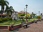 Park and plaza
 Saint John the Evangelist Parish Church
 The bamboo makeshifts


References
- Municipality of Orani | (DILG)
- "2015 Census of Population, Report No. 3 – Population, Land Area, and Population Density" (PDF). Philippine Statistics Authority. Quezon City, Philippines. August 2016. ISSN 0117-1453. Archived (PDF) from the original on May 25, 2021. Retrieved July 16, 2021.
- Census of Population (2020). "Region III (Central Luzon)". Total Population by Province, City, Municipality and Barangay. PSA. Retrieved 8 July 2021.
- "PSA Releases the 2018 Municipal and City Level Poverty Estimates". Philippine Statistics Authority. 15 December 2021. Retrieved 22 January 2022.
- "Province: Bataan". PSGC Interactive. Quezon City, Philippines: Philippine Statistics Authority. Retrieved 12 November 2016.
- "Orani: Average Temperatures and Rainfall". Meteoblue. Retrieved 26 April 2020.
- "Municipal: Orani". PSGC Interactive. Quezon City, Philippines: Philippine Statistics Authority. Retrieved 8 January 2016.
- Census of Population and Housing (2010). "Region III (Central Luzon)". Total Population by Province, City, Municipality and Barangay. NSO. Retrieved 29 June 2016.
- Census of Population (2015). "Region III (Central Luzon)". Total Population by Province, City, Municipality and Barangay. PSA. Retrieved 20 June 2016.
- Censuses of Population (1903–2007). "Region III (Central Luzon)". Table 1. Population Enumerated in Various Censuses by Province/Highly Urbanized City: 1903 to 2007. NSO.
- "Province of Bataan". Municipality Population Data. Local Water Utilities Administration Research Division. Retrieved 17 December 2016.
- "Poverty incidence (PI):". Philippine Statistics Authority. Retrieved 28 December 2020.
- https://psa.gov.ph/sites/default/files/NSCB_LocalPovertyPhilippines_0.pdf; publication date: 29 November 2005; publisher: Philippine Statistics Authority.
- https://psa.gov.ph/sites/default/files/2003%20SAE%20of%20poverty%20%28Full%20Report%29_1.pdf; publication date: 23 March 2009; publisher: Philippine Statistics Authority.
- https://psa.gov.ph/sites/default/files/2006%20and%202009%20City%20and%20Municipal%20Level%20Poverty%20Estimates_0_1.pdf; publication date: 3 August 2012; publisher: Philippine Statistics Authority.
- https://psa.gov.ph/sites/default/files/2012%20Municipal%20and%20City%20Level%20Poverty%20Estima7tes%20Publication%20%281%29.pdf; publication date: 31 May 2016; publisher: Philippine Statistics Authority.
- https://psa.gov.ph/sites/default/files/City%20and%20Municipal-level%20Small%20Area%20Poverty%20Estimates_%202009%2C%202012%20and%202015_0.xlsx; publication date: 10 July 2019; publisher: Philippine Statistics Authority.
- "PSA Releases the 2018 Municipal and City Level Poverty Estimates". Philippine Statistics Authority. 15 December 2021. Retrieved 22 January 2022.
- "Philippines : Gov.Ph : About the Philippines". Gov.ph. Archived from the original on 2006-10-03. Retrieved 2009-03-28.
- "the Local Government Code of the Philippines (Republic Act No. 7160)". Chan Robles Virtual Law Library. Retrieved 19 January 2021.
- "Municipality of Orani". Provincial Government of Bataan. Archived from the original on 2 April 2012. Retrieved 21 November 2016.
- "Orani, Bataan Candidates". Know Your Candidates. Archived from the original on 14 October 2010. Retrieved 19 January 2021.
- "Orani adopts anti-discrimination ordinance". 10 January 2019.
- "Orani's Historical Landmarks". Municipality of Orani. 17 November 2010. Archived from the original on 8 December 2013. Retrieved 21 November 2016.
- Pawikan Festival 2012 Orani Bataan. YouTube. 30 November 2012. Archived from the original on 2021-12-21. Retrieved 15 July 2015.
External links
Places adjacent to Orani | ||||||||||||||||
|---|---|---|---|---|---|---|---|---|---|---|---|---|---|---|---|---|
| ||||||||||||||||
Balanga (capital) | |
| Municipalities | |
| Component city | |
На других языках
[de] Orani (Bataan)
Orani ist eine philippinische Stadtgemeinde in der Provinz Bataan. Sie hat 66.909 Einwohner (Zensus 1. August 2015). Der Bataan-Nationalpark und der Berg Natib liegen im Südwesten der Gemeinde.- [en] Orani
Другой контент может иметь иную лицензию. Перед использованием материалов сайта WikiSort.org внимательно изучите правила лицензирования конкретных элементов наполнения сайта.
WikiSort.org - проект по пересортировке и дополнению контента Википедии