world.wikisort.org - Philippines
Calanasan, officially the Municipality of Calanasan, (Ilocano: Ili ti Calanasan; Tagalog: Bayan ng Calanasan), (formerly known as Bayag,[5] meaning "slow") is a 1st class municipality in the province of Apayao, Philippines. According to the 2020 census, it has a population of 12,550 people. [3]
This article uses bare URLs, which are uninformative and vulnerable to link rot. (September 2022) |
This article needs additional citations for verification. (January 2014) |
Calanasan
Bayag | |
|---|---|
Municipality | |
| Municipality of Calanasan | |
 Map of Apayao with Calanasan highlighted | |
OpenStreetMap OpenStreetMap  | |
 Calanasan Location in the Philippines | |
| Coordinates: 18°15′18″N 121°02′37″E | |
| Country | Philippines |
| Region | Cordillera Administrative Region |
| Province | Apayao |
| District | Lone district |
| Founded | June 25, 1963 |
| Barangays | 18 (see Barangays) |
| Government | |
| • Type | Sangguniang Bayan |
| • Mayor | Shamir M. Bulut (NP) |
| • Vice Mayor | Martin Lucero B. Lawat (NPC) |
| • Representative | Eleanor Bulut-Begtang |
| • Municipal Council | Members |
| • Electorate | 8,243 voters (2019) |
| Area | |
| • Total | 1,256.15 km2 (485.00 sq mi) |
| Elevation | 554 m (1,818 ft) |
| Highest elevation | 1,220 m (4,000 ft) |
| Lowest elevation | 258 m (846 ft) |
| Population | |
| • Total | 12,550 |
| • Density | 10.0/km2 (26/sq mi) |
| • Households | 2,382 |
| Economy | |
| • Income class | 1st municipal income class |
| • Poverty incidence | 29.81% (2018)[4] |
| • Revenue | ₱297,414,148.37 (2020) |
| • Assets | ₱700,689,356.51 (2020) |
| • Expenditure | ₱204,794,971.43 (2020) |
| • Liabilities | ₱88,924,468.92 (2020) |
| Service provider | |
| • Electricity | Kalinga - Apayao Electric Cooperative (KAELCO) |
| Time zone | UTC+8 (PST) |
| ZIP code | 3814 |
| PSGC | |
| IDD : area code | +63 (0)74 |
| Native languages | Isnag Ilocano Tagalog |
Its land area is 1,256.15 square kilometres (485.00 sq mi), making it the largest municipality in the province. Calanasan is the source of the Apayao River which empties into the South China Sea and is the only navigable river in Apayao.
Geography
According to the Philippine Statistics Authority, the municipality has a land area of 1,256.15 square kilometres (485.00 sq mi) [6] constituting 28.46% of the 4,413.35-square-kilometre- (1,704.00 sq mi) total area of Apayao.
Calanasan is 607 kilometres (377 mi) north from Manila and located in the north-western section of Apayao bordering Santa Praxedes and Claveria in the north, Adams and Carasi in the west, Solsona in the south-west, Kabugao on the south, and Luna and some parts of Kabugao on the east.
The town's topography or slope is predominantly rugged and mountainous with sporadic flood plains and plateaus. The municipality cradles the larger part of the Apayao-Abulog watershed area as the main source of streams that fills the mighty river which originates from the municipality.
Calanasan has two pronounced seasons, the dry and the wet seasons. The dry season starts in the latest part of December and ends in the middle part of June. The wet season starts in July and ends in the middle part of December. The hottest month is May and rainfall is heaviest in August while strong typhoons usually occur within the period of August to October and the December used to be the coolest month.
Barangays
Calanasan is politically subdivided into 20 barangays.[7] These barangays are headed by elected officials: Barangay Captain, Barangay Council, whose members are called Barangay Councilors. All are elected every three years.
| PSGC | Barangay | Population | ±% p.a. | |||
|---|---|---|---|---|---|---|
| 2020 [3] | 2010 [8] | |||||
| 148101001 | Butao | 6.6% | 832 | 672 | 2.07% | |
| 148101002 | Cadaclan | 5.0% | 629 | 437 | 3.55% | |
| 148101013 | Don Roque Ablan Sr. | 1.9% | 239 | 273 | −1.27% | |
| 148101014 | Eleazar | 1.1% | 139 | 121 | 1.34% | |
| 148101015 | Eva Puzon | 10.0% | 1,254 | 1,072 | 1.51% | |
| 148101016 | Kabugawan | 4.1% | 519 | 484 | 0.67% | |
| 148101003 | Langnao | 1.8% | 229 | 164 | 3.25% | |
| 148101004 | Lubong | 3.9% | 494 | 612 | −2.03% | |
| 148101017 | Macalino | 2.8% | 348 | 265 | 2.64% | |
| 148101005 | Naguilian | 2.6% | 332 | 389 | −1.51% | |
| 148101006 | Namaltugan | 7.3% | 918 | 924 | −0.06% | |
| 148101007 | Poblacion | 16.0% | 2,008 | 1,939 | 0.34% | |
| 148101008 | Sabangan | 3.6% | 454 | 379 | 1.74% | |
| 148101018 | Santa Elena | 2.3% | 292 | 221 | 2.70% | |
| 148101009 | Santa Filomena | 8.0% | 1,002 | 859 | 1.49% | |
| 148101011 | Tanglagan | 16.1% | 2,018 | 1,951 | 0.32% | |
| 148101012 | Tubang | 3.6% | 456 | 411 | 1.00% | |
| 148101010 | Tubongan | 3.5% | 441 | 395 | 1.06% | |
| Total | 12,550 | 11,568 | 0.78% | |||
Climate
| Climate data for Calanasan, Apayao | |||||||||||||
|---|---|---|---|---|---|---|---|---|---|---|---|---|---|
| Month | Jan | Feb | Mar | Apr | May | Jun | Jul | Aug | Sep | Oct | Nov | Dec | Year |
| Average high °C (°F) | 24 (75) |
26 (79) |
28 (82) |
30 (86) |
29 (84) |
29 (84) |
28 (82) |
28 (82) |
28 (82) |
27 (81) |
26 (79) |
24 (75) |
27 (81) |
| Average low °C (°F) | 18 (64) |
18 (64) |
19 (66) |
21 (70) |
23 (73) |
23 (73) |
23 (73) |
23 (73) |
22 (72) |
21 (70) |
20 (68) |
19 (66) |
21 (69) |
| Average precipitation mm (inches) | 55 (2.2) |
41 (1.6) |
37 (1.5) |
41 (1.6) |
184 (7.2) |
215 (8.5) |
261 (10.3) |
256 (10.1) |
245 (9.6) |
216 (8.5) |
142 (5.6) |
129 (5.1) |
1,822 (71.8) |
| Average rainy days | 14.1 | 11.1 | 11.8 | 12.5 | 21.8 | 25.2 | 25.5 | 24.9 | 23.8 | 18.2 | 16.4 | 17.0 | 222.3 |
| Source: Meteoblue (Use with caution: this is modeled/calculated data, not measured locally.)[9] | |||||||||||||
Demographics
| Year | Pop. | ±% p.a. |
|---|---|---|
| 1918 | 2,509 | — |
| 1939 | 2,743 | +0.43% |
| 1948 | 3,550 | +2.91% |
| 1960 | 3,740 | +0.44% |
| 1970 | 5,214 | +3.37% |
| 1975 | 5,727 | +1.90% |
| 1980 | 5,556 | −0.60% |
| 1990 | 10,699 | +6.77% |
| 1995 | 11,679 | +1.66% |
| 2000 | 12,806 | +1.99% |
| 2007 | 9,663 | −3.81% |
| 2010 | 11,568 | +6.77% |
| 2015 | 12,604 | +1.65% |
| 2020 | 12,550 | −0.08% |
| Source: Philippine Statistics Authority [10] [8] [11][12] | ||
In the 2020 census, Calanasan had a population of 12,550. [3] The population density was 10.0 inhabitants per square kilometre (26/sq mi).
Calanasan is dominated by the Isnag people, living with them are the Ilocanos, Igorots and Kalingas. The main languages spoken are the Isnag and the Ilocano.
Economy
Economic activity in the municipality is based on agricultural production like farming and fishing and livelihood activities like basketry, soft broom making and furniture making.
The municipality has no level lands for extensive rice production except in the northern part of the municipality. The total land area devoted to agriculture is 45.316 hectares (111.98 acres) in which total land area irrigated is 2,347.49 hectares (5,800.8 acres). Its produce include coffee, corn, root crops, peanuts and other legumes, banana, pineapple and some vegetables.
Government
Calanasan, belonging to the lone congressional district of the province of Apayao, is governed by a mayor designated as its local chief executive and by a municipal council as its legislative body in accordance with the Local Government Code. The mayor, vice mayor, and the councilors are elected directly by the people through an election which is being held every three years.
Elected officials
| Position | Name |
|---|---|
| Congressman | Elias C. Bulut Jr. |
| Mayor | Martin Lucero B. Lawat |
| Vice-Mayor | Shamir M. Bulut |
| Councilors | Kyle Mariah Chelsea S. Bulut |
| Edgar B. Bulsao | |
| Harold Cliff L. Danggan | |
| Denish C. Agubo | |
| Irene U. Iddaro | |
| Naville D. Taccalan | |
| Rodante B. Labueng | |
| Juliet D. Aliga | |
Tourism
The town has vast variety of wild flora and fauna which contributes to its eco-tourism potential. The town is surrounded with virgin forests, cascading waterfalls, and clear rivers.
Potential tourist attractions include:
- Apayao River — Poblacion
- Girgirra’ Falls — Ninoy Aquino
- Ziwanan River — Cadaclan
- Maxibab Falls — Santa Filomena
- Carmella Falls — Eva
- Pisong Lake
- Danao Lake — Sitio Danao, Poblacion
- Purit Cave
- Bantay Malingudu — Poblacion
- Agamata National Park and Wildlife Sanctuary — near the Ilocos Norte boundary, was established in the remote area of sharp peaks and plateaus. This undeveloped area, with pine stands, lush vegetation and mossy forest, affords a panoramic view of Ilocos Norte and Laoag City on the west. It is ideal for hiking, camping, nature tripping and bird watching.
- Blue Haven
- Mount Kilang
Festivals
- Sinandila/Sinursor Festival and Pippiru' Festival (Boat Racing) — celebrated every third week of March
- Calanasan Town Fiesta — celebrated every March which is coming together of the people of Calanasan, The month-long activities highlights the Agro-Industrial and trade fair which showcase the different products of Calanasan and Highlights also the Sports fest, Calanasan got Talent and the Street Dance Competition together with most awaited part the "Search for Miss Dam-ag naya Calanasan".
- Say-Am Festival — is a feast featuring and ushering the traditional way of Isnag's thanksgiving to the Higher Supreme unseen being called "Alawagan" executed and commence through rituals spiced with pep songs, native chants and dances called the "Talip" and "Tad-do". The holding and celebration of Say-am in the older days connotes status - that the family is respectable and well-to-do. It is Celebrated every third week of March.
Philippine Eagle Sanctuary
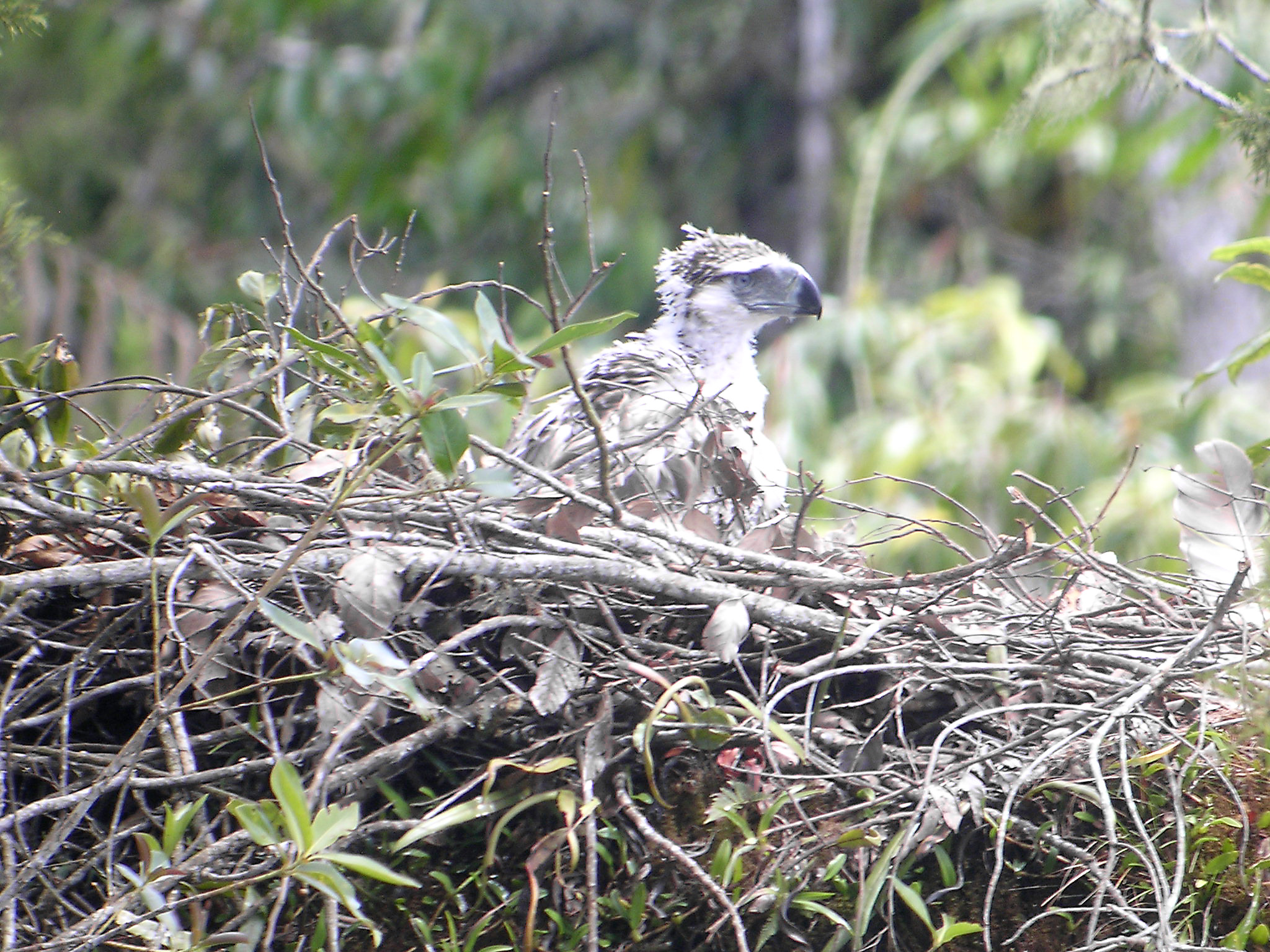
The Philippine Eagle Foundation began its search of eagles in Apayao in 2011 after reports of huge eagles were roaming the area for centuries.[21] On March 22, 2013, scientists discovered the stronghold of critically endangered Philippine eagles, the country's national bird, in Luzon island within the vicinity of the Calanasan Lowland Forest.[22] In January 2015, the town of Calanasan initiated a program which protected 3,000 hectares of forests under its jurisdiction.[23] Additionally, the province of Apayao is one of the very few in the country which has an approved forest land use plan (FLUP).[24] The first active Philippine eagle nest in Apayao was discovered in July 2015.[25]
On 9 July 2018,[26] the provincial government of Apayao announced their intent for the province to be a UNESCO Biosphere Reserve. The province, which possesses more than 286,000 hectares of virgin forests, also noted that they have sent four of their personnel to train in the United States under the US Foreign Service to hasten the declaration of the site.[27] On January 16, 2019, the provincial government announced that they are at the 'legwork for the inscription'.[28]
See also
- List of renamed cities and municipalities in the Philippines
References
- Municipality of Calanasan | (DILG)
- "2015 Census of Population, Report No. 3 – Population, Land Area, and Population Density" (PDF). Philippine Statistics Authority. Quezon City, Philippines. August 2016. ISSN 0117-1453. Archived (PDF) from the original on May 25, 2021. Retrieved July 16, 2021.
- Census of Population (2020). "Cordillera Administrative Region (CAR)". Total Population by Province, City, Municipality and Barangay. PSA. Retrieved 8 July 2021.
- "PSA Releases the 2018 Municipal and City Level Poverty Estimates". Philippine Statistics Authority. 15 December 2021. Retrieved 22 January 2022.
- "Republic Act No. 4980 - An Act Changing the Name of the Municipality of Bayag, Mountain Province, to Calanasan". Chan Robles Virtual Law Library. 17 June 1967. Archived from the original on 4 March 2016. Retrieved 4 November 2016.
- "Province: Apayao". PSGC Interactive. Quezon City, Philippines: Philippine Statistics Authority. Retrieved 12 November 2016.
- "Municipal: Calanasan". PSGC Interactive. Quezon City, Philippines: Philippine Statistics Authority. Retrieved 8 January 2016.
- Census of Population and Housing (2010). "Cordillera Administrative Region (CAR)". Total Population by Province, City, Municipality and Barangay. NSO. Retrieved 29 June 2016.
- "Calanasan: Average Temperatures and Rainfall". Meteoblue. Retrieved 8 March 2020.
- Census of Population (2015). "Cordillera Administrative Region (CAR)". Total Population by Province, City, Municipality and Barangay. PSA. Retrieved 20 June 2016.
- Censuses of Population (1903–2007). "Cordillera Administrative Region (CAR)". Table 1. Population Enumerated in Various Censuses by Province/Highly Urbanized City: 1903 to 2007. NSO.
- "Province of Apayao". Municipality Population Data. Local Water Utilities Administration Research Division. Retrieved 17 December 2016.
- "Poverty incidence (PI):". Philippine Statistics Authority. Retrieved 28 December 2020.
- https://psa.gov.ph/sites/default/files/NSCB_LocalPovertyPhilippines_0.pdf; publication date: 29 November 2005; publisher: Philippine Statistics Authority.
- https://psa.gov.ph/sites/default/files/2003%20SAE%20of%20poverty%20%28Full%20Report%29_1.pdf; publication date: 23 March 2009; publisher: Philippine Statistics Authority.
- https://psa.gov.ph/sites/default/files/2006%20and%202009%20City%20and%20Municipal%20Level%20Poverty%20Estimates_0_1.pdf; publication date: 3 August 2012; publisher: Philippine Statistics Authority.
- https://psa.gov.ph/sites/default/files/2012%20Municipal%20and%20City%20Level%20Poverty%20Estima7tes%20Publication%20%281%29.pdf; publication date: 31 May 2016; publisher: Philippine Statistics Authority.
- https://psa.gov.ph/sites/default/files/City%20and%20Municipal-level%20Small%20Area%20Poverty%20Estimates_%202009%2C%202012%20and%202015_0.xlsx; publication date: 10 July 2019; publisher: Philippine Statistics Authority.
- "PSA Releases the 2018 Municipal and City Level Poverty Estimates". Philippine Statistics Authority. 15 December 2021. Retrieved 22 January 2022.
- "2019 National and Local Elections" (PDF). Commission on Elections. Archived (PDF) from the original on 2020-10-06. Retrieved March 12, 2022.
- "First active Philippine eagle nest in Luzon found in Apayao". 14 July 2015.
- "Eagle Sightings in Apayao - Philippine Eagle Foundation - the official website of the Philippine Eagle Foundation". Archived from the original on 2019-02-09. Retrieved 2019-02-07.
- http://bayanihan.org/2015/01/06/apayao-folk-help-protect-3000-hectares-wildlife-sanctuary/
- "Apayao eagle habitat eyed as Unesco protected area". The Philippine STAR.
- "First active Philippine eagle nest in Luzon found in Apayao". 14 July 2015.
- "Apayao eagle habitat eyed as Unesco protected area". The Philippine STAR.
- "Gov Bulut wants Calanasan Philippine Eagle sanctuary declared as protected area | Politiko North Luzon". 27 July 2018.
- "Apayao eyes UNESCO biosphere reserve title to save PH eagles". Philippine News Agency.
External links
![]() Media related to Calanasan at Wikimedia Commons
Media related to Calanasan at Wikimedia Commons
Places adjacent to Calanasan | ||||||||||||||||
|---|---|---|---|---|---|---|---|---|---|---|---|---|---|---|---|---|
| ||||||||||||||||
Kabugao (capital) | |
| Municipalities | |
| Barangays | See: List of barangays in Apayao |
На других языках
[de] Calanasan
Calanasan (Bayag) ist eine philippinische Stadtgemeinde in der Provinz Apayao. Sie hat 12.604 Einwohner (Zensus 1. August 2015). Die Gemeinde liegt im Wassereinzugsgebiet des Flusses Abulug, der seine Quelle am Mount Manta hat.- [en] Calanasan
Другой контент может иметь иную лицензию. Перед использованием материалов сайта WikiSort.org внимательно изучите правила лицензирования конкретных элементов наполнения сайта.
WikiSort.org - проект по пересортировке и дополнению контента Википедии