world.wikisort.org - Peru
San Martín de Porres (SMP) is a district in Lima, Peru, located in the north area of the city. It is bordered by the Chillón River, marks its natural border with Ventanilla and Puente Piedra on the north; Callao on the west; Los Olivos on the northeast; Comas, Rímac and Independencia districts on the east; The Rímac River marks its natural border with Lima District and Carmen de la Legua Reynoso on the south.
San Martín de Porres | |
|---|---|
District | |
 Flag  Coat of arms | |
 Location of San Martín de Porres in Lima | |
| Country | |
| Region | Lima |
| Province | Lima |
| Created | May 22, 1950 |
| Capital | Barrio Obrero Industrial |
| Government | |
| • Mayor | Julio Chávez Chiong (2019-2022) |
| Area | |
| • Total | 41.5 km2 (16.0 sq mi) |
| Elevation | 123 m (404 ft) |
| Population (2017)[1] | |
| • Total | 654,083 |
| • Density | 16,000/km2 (41,000/sq mi) |
| Time zone | UTC-5 (PET) |
| UBIGEO | 150135 |
| Website | mdsmp.gob.pe |

History
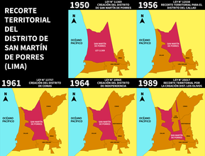
Since 1945, continuous invasions of territory in what was then part of the Carabayllo District, ended up in the creation of the Distrito Obrero Industrial 27 de Octubre on May 22, 1950, which is still celebrated as the district's anniversary. The district was composed of the following haciendas: Chuquitanta, Pro, Naranjal, Infantas, Santa Rosa, Garagay Alto, G. Bajo, Chavarría, Mulería, Aliaga, Condevilla, San José, Palao, Huerta Sol, Oquendo, San Agustín and Marquez. The last three became part of Callao province, in 1956.
In 1962, after the canonization of St. Martin de Porras, the name of the district was changed to its current name. Although historians have shown that the saint's actual last name was Porras, the district has retained the original spelling. The Barrio Obrero Industrial name is unofficially kept for the downtown area.
The district of Los Olivos was created in 1989, stripping some of San Martín de Porres' northeastern territory.
A prominent geographical feature of the district is the isolated La Milla hill, which is north of Ave. José Granda.
Geography
The district has a total land area of 41.5 km²[2]

Authorities
Mayors
- 2019-2022: Julio Abraham Chávez Chiong (AP)
- 2015-2018: Adolfo Israel Mattos Piaggio (SU)
- 2011-2014: Freddy Ternero † (PPC)
- 2007-2010: Freddy Ternero † (SP)
- 2003-2006: Lucio Campos Huayta (UN)
- 1999-2002: Gladys Ugaz de Vera (SP)
- 1996-1998: Jaime Kanashiro Ywamoto (C90-NM)
- 1993-1995: José Arcenio Rubio Valqui (OBRAS)
- 1990-1992: Marcelino Morales Scandon (FREDEMO-AP)
- 1987-1989: José Isaac Miranda Valladares (IU)
- 1984-1986: José Isaac Miranda Valladares (IU)
- 1981-1983: Willy Fernández Melo (IU)
- 1967-1969: Enrique León Velarde Gamarra † (AP-DC)
- 1964-1966: Víctor Reyes Ramos (APRA-UNO)

Universities
- Cayetano Heredia University

Avenues
- Carretera Panamericana Norte (PE-1N Pan American highway)
- Avenida Caquetá
- Avenida Zarumilla (PE-1N)
- Avenida Eduardo de Habich
- Avenida Túpac Amaru (PE-20A)
- Avenida Canta Callao (PE-20)
- Avenida Naranjal
- Avenida Carlos Izaguirre
- Avenida Los Alisos
- Avenida 25 de Enero
- Avenida San Bernardo
- Avenida Próceres
- Avenida Bocanegra
- Avenida Angélica Gamarra
- Avenida Tomás Valle
- Avenida Universitaria
- Avenida Germán Aguirre
- Avenida José Granda
- Avenida Lima
- Avenida Pacasmayo
- Avenida Perú
- Avenida Los Próceres
- Avenida 12 de Octubre
- Avenida Salaverry
- Avenida Quilca
Neighborhoods
- Urb Barrio Obrero
- Urb Caquetá
- Urb Miguel Grau
- Urb Zarumilla
- Urb Ingenieria
- Urb Palao
- Urb Los Jardines
- Urb Fiori
- Urb Naranjal
- Urb Mesa Redonda
- Urb Industrial Panamericana
- Urb Infantas
- Urb Santa Luisa
- Urb Industrial Pro
- Urb Perú
- Urb Condevilla Señor
- Urb San Germán
- Urb Antares
- Urb Los Libertadores
- Urb El Pacífico
- Urb Garagay
- Urb Valdivieso
Pre-Hispanic Buildings (Huacas)
- Huaca El Paraiso
- Huaca Garagay
- Huaca Palao


See also
- Administrative divisions of Peru
- Largest cities in the Americas
- List of districts of Lima
- List of metropolitan areas of Peru
- List of people from Lima
- List of sites of interest in the Lima Metropolitan area
- Ancient Buildings in Coast of Peru
References
- "Estadística Poblacional - Ministerio de Salud del Perú".
- Mayor of San Martin de Porres. "Details of San Martin de Porres".
External links
- (in Spanish) Municipalidad Distrital de San Martín de Porres - San Martín de Porres district council official website
- (in Spanish) Universidad Cayetano Heredia
На других языках
[de] Distrikt San Martín de Porres
Der Distrikt San Martín de Porres ist einer der 43 Stadtbezirke der Region Lima Metropolitana in Peru. Er hat eine Fläche von 36,91 km². Beim Zensus 2017 wurden 654.083 Einwohner gezählt. Im Jahr 1993 lag die Einwohnerzahl bei 380.384, im Jahr 2007 bei 579.561. Der Distrikt wurde am 22. Mai 1950 gegründet. Die Distriktverwaltung liegt auf einer Höhe von 123 m. Die Nationalstraße 1N (Panamericana) führt durch den Südosten des Distrikts.- [en] San Martín de Porres District
Другой контент может иметь иную лицензию. Перед использованием материалов сайта WikiSort.org внимательно изучите правила лицензирования конкретных элементов наполнения сайта.
WikiSort.org - проект по пересортировке и дополнению контента Википедии