world.wikisort.org - Peru
The Pamparomas District is one of 10 districts of the Huaylas Province in the Ancash Region of Peru. The capital of the district is the village of Pamparomas.[1] The district was founded on January 2, 1857.
Pamparomas
Pamparumas | |
|---|---|
District | |
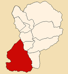 Location of Pamparomas in the Huaylas province | |
| Country |  Peru Peru |
| Region | Ancash |
| Province | Huaylas |
| Founded | January 2, 1857 |
| Capital | Pamparomas |
| Subdivisions | 43 hamlets |
| Government | |
| • Mayor | Adrián Palmadera Milla (2012) |
| Area | |
| • Total | 496.35 km2 (191.64 sq mi) |
| Elevation | 2,862 m (9,390 ft) |
| Population (2002 est.) | |
| • Total | 9,484 |
| • Density | 19/km2 (49/sq mi) |
| Time zone | UTC-5 (PET) |
| UBIGEO | 021206 |
| Website | munipamparomas.gob.pe |
Location
The district is located in the south-western part of the province at an elevation of 2,862m in the Cordillera Negra (Spanish for black mountain range). The capital of the province, Caraz, is located at a distance of 80 km. The nearest large city is Chimbote, located on the pacific coast at a distance of 140 km from Pamparomas.
Geography
One of the highest peaks of the district is Simiyuq Wank'a at approximately 4,600 m (15,100 ft). Other mountains are listed below:[2]
- Allqu Rukutu
- Ch'ampa Hirka Punta
- Hatun Hirka
- Hatun Kunka
- Ichik Punta
- Kachi P'unqu
- Kukuli
- Kuntur Marka
- Kuntuyuq
- Kurakayuq
- Paka Qutu
- Pampa Kancha
- Parya Qutu
- Puka Qaqa
- Putaqa
- Qaqa Rumi Kunka
- Qarwa Qhari
- T'uru Punta
- Wamp'u
- Wamp'u (Huaylas-Yungay)
- Yawri
- Yuraq Waqta
Political division
The district is divided into 43 hamlets (Spanish: caseríos, singular: caserío):
Pamparomas Valley
|
Chaclancayo Valley
|
Pisha Valley
|
Ethnic groups
The people in the district are mainly indigenous citizens of Quechua descent. Quechua is the language which the majority of the population (81.62%) learnt to speak in childhood, 18.19% of the residents started speaking using the Spanish language (2007 Peru Census).[3]
References
- (in Spanish) Official website of the Pamparomas District Archived 2007-03-29 at the Wayback Machine
- escale.minedu.gob.pe/ UGEL map Huaylas Province (Ancash Region)
- inei.gob.pe Archived 2013-01-27 at the Wayback Machine INEI, Peru, Censos Nacionales 2007, Frequencias: Preguntas de Población: Idioma o lengua con el que aprendió hablar (in Spanish)
External links
- (in Spanish) Official website of the Pamparomas District
 Districts of Ancash Region, Peru Districts of Ancash Region, Peru | |
|---|---|
| Aija | |
| Antonio Raymondi |
|
| Asunción | |
| Bolognesi |
|
| Carhuaz | |
| Carlos Fermín Fitzcarrald |
|
| Casma |
|
| Corongo | |
| Huaraz |
|
| Huari |
|
| Huarmey |
|
| Huaylas |
|
| Mariscal Luzuriaga |
|
| Ocros |
|
| Pallasca |
|
| Pomabamba | |
| Recuay |
|
| Santa | |
| Sihuas |
|
| Yungay |
|
 | This Ancash Region geography article is a stub. You can help Wikipedia by expanding it. |
Другой контент может иметь иную лицензию. Перед использованием материалов сайта WikiSort.org внимательно изучите правила лицензирования конкретных элементов наполнения сайта.
WikiSort.org - проект по пересортировке и дополнению контента Википедии