world.wikisort.org - Peru
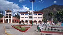
Tinco District is one of eleven districts of the province Carhuaz in Peru.[1]
Tinco
Tinku | |
|---|---|
District | |
 Tinco | |
 Flag  Coat of arms | |
 Tinco Location within Peru | |
| Coordinates: 9°16′14.56″S 77°40′40.22″W | |
| Country | |
| Region | Ancash |
| Province | Carhuaz |
| Founded | September 30, 1941 |
| Capital | Tinco |
| Government | |
| • Mayor | Agripino Rusbany Cochachin Minaya (2019-2022) |
| Area | |
| • Total | 15.44 km2 (5.96 sq mi) |
| Elevation | 2,588 m (8,491 ft) |
| Population (2005 census) | |
| • Total | 3,145 |
| • Density | 200/km2 (530/sq mi) |
| Time zone | UTC-5 (PET) |
| UBIGEO | 020610 |
References
- (in Spanish) Instituto Nacional de Estadística e Informática. Banco de Información Distrital Archived 2008-04-10 at the Wayback Machine. Retrieved April 11, 2008.
Текст в блоке "Читать" взят с сайта "Википедия" и доступен по лицензии Creative Commons Attribution-ShareAlike; в отдельных случаях могут действовать дополнительные условия.
Другой контент может иметь иную лицензию. Перед использованием материалов сайта WikiSort.org внимательно изучите правила лицензирования конкретных элементов наполнения сайта.
Другой контент может иметь иную лицензию. Перед использованием материалов сайта WikiSort.org внимательно изучите правила лицензирования конкретных элементов наполнения сайта.
2019-2025
WikiSort.org - проект по пересортировке и дополнению контента Википедии
WikiSort.org - проект по пересортировке и дополнению контента Википедии