world.wikisort.org - Peru
Chipao District is one of twenty-one districts of the province Lucanas in Peru.[1]
Geography Not Historical
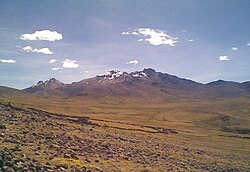
Some of the highest mountains in the district are Rasuwillka and Qarwarasu. Other mountains are listed below:[2]
- Anta P'ukru
- Anta Urqu
- Aqu P'ukru
- Aqu Urqu
- Chakra Pata
- Chunta
- Ichhu Qutu
- Jayuni
- Misk'i Pata
- Palla Palla
- Parqa Parqa
- Pawkaray
- Pichqaqucha
- Puka Muqu
- Puka Punchu
- Puka Salla
- Phiruru
- Qarwa Uqhu
- Qullpa Punta
- Q'illu Q'asa
- Q'illu Urqu
- Sallqan Tiwa
- Sapan Urqu
- Silla Q'asa
- Surapata
- Titi Q'asa
- Uqi
- Waman Pirqa
- Waych'ayuq
- Waylla Wit'u
- Waytayuq
- Yana Ranra
- Yana Yana
- Yunka
- Yuraq Pata
Ethnic groups
The people in the district are mainly indigenous citizens of Quechua descent. Quechua is the language which the majority of the population (73.03%) learnt to speak in childhood, 26.54% of the residents started speaking using the Spanish language (per the 2007 Peru Census).[3]
See also
- Apiñaqucha
- Aya Muqu
- Chawpiqucha
- Chipaw Marka
- Islaqucha
- Sawaqucha
- Suyt'uqucha
- Urqunqucha
- Wat'aqucha
References
- (in Spanish) Instituto Nacional de Estadística e Informática. Banco de Información Distrital Archived April 23, 2008, at the Wayback Machine. Retrieved April 11, 2008.
- escale.minedu.gob.pe - UGEL map of the Lucanas Province 2 (Ayacucho Region)
- inei.gob.pe Archived January 27, 2013, at the Wayback Machine INEI, Peru, Censos Nacionales 2007, Frequencias: Preguntas de Población: Idioma o lengua con el que aprendió hablar (in Spanish)
На других языках
[de] Distrikt Chipao
Der Distrikt Chipao liegt in der Provinz Lucanas in der Region Ayacucho in Südzentral-Peru. Der Distrikt besitzt eine Fläche von 1156 km². Beim Zensus 2017 wurden 2702 Einwohner gezählt. Im Jahr 1993 lag die Einwohnerzahl bei 3804, im Jahr 2007 bei 3965. Sitz der Distriktverwaltung ist die 3420 m hoch gelegene Ortschaft Chipao mit 1054 Einwohnern (Stand 2017). Chipao liegt 45 km nordöstlich der Provinzhauptstadt Puquio.- [en] Chipao District
[es] Distrito de Chipao
Chipao es uno de los veintiún distritos que conforman la Provincia de Lucanas, ubicada en el Departamento de Ayacucho, perteneciente al departamento de Ayacucho, en el Perú. Se encuentra al pie del volcán del Ccarhuarazo, componente de la Micro cuenca del Valle de Sondondo. La capital de distrito se ubica a 95 km de la capital de la Provincia (Puquio).Текст в блоке "Читать" взят с сайта "Википедия" и доступен по лицензии Creative Commons Attribution-ShareAlike; в отдельных случаях могут действовать дополнительные условия.
Другой контент может иметь иную лицензию. Перед использованием материалов сайта WikiSort.org внимательно изучите правила лицензирования конкретных элементов наполнения сайта.
Другой контент может иметь иную лицензию. Перед использованием материалов сайта WikiSort.org внимательно изучите правила лицензирования конкретных элементов наполнения сайта.
2019-2025
WikiSort.org - проект по пересортировке и дополнению контента Википедии
WikiSort.org - проект по пересортировке и дополнению контента Википедии
