world.wikisort.org - Pakistan
Makwal Kalan union council is in the Taunsa Tehsil subdivision of Dera Ghazi Khan District in the Punjab province of Pakistan,[1] and is located at 30°35'06"N 70°43'55"E at an altitude of 135 metres (443 ft).[2]
Makwal Kalan | |
|---|---|
Union council and town | |
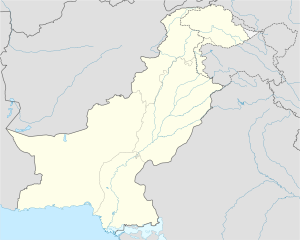
 Makwal Kalan Location in Pakistan | |
| Coordinates: 30°35′00″N 70°44′00″E | |
| Country | Pakistan |
| Province | Punjab |
| District | Dera Ghazi Khan District |
| Elevation | 443 ft (135 m) |
| Time zone | UTC+5 (PST) |
| • Summer (DST) | +6 |
Makwal Kalan is 60 km radially north of Dera Ghazi Khan and is 4 km from the geographical centre of Pakistan, close to the Sulaiman Mountains and Taunsa Barrage.
The major tribe in the town is the Nutkani Jamali Baloch. The fertile agricultural lands produce many different crops.
During the floods in 2010, people from the town hosted many flood victims.[citation needed]
See also
- Government Boys High School Makwal Kalan
Wantsn69 kids
References
- Tehsils & Unions in the District of D.G. Khan - Government of Pakistan Archived 2012-02-09 at the Wayback Machine
- Location of Makwal Kalan - Falling Rain Genomics
Текст в блоке "Читать" взят с сайта "Википедия" и доступен по лицензии Creative Commons Attribution-ShareAlike; в отдельных случаях могут действовать дополнительные условия.
Другой контент может иметь иную лицензию. Перед использованием материалов сайта WikiSort.org внимательно изучите правила лицензирования конкретных элементов наполнения сайта.
Другой контент может иметь иную лицензию. Перед использованием материалов сайта WikiSort.org внимательно изучите правила лицензирования конкретных элементов наполнения сайта.
2019-2025
WikiSort.org - проект по пересортировке и дополнению контента Википедии
WikiSort.org - проект по пересортировке и дополнению контента Википедии