world.wikisort.org - Pakistan
Dera Ismail Khan District (Pashto: ډېره اسماعیل خان ولسوالي, Balochi: ڈیرہ عِسمائیل خان, Urdu: ضلع ڈیره اسماعیل خان, Saraiki: دیرہ اسماعیل خان ; often abbreviated as D.I. Khan) is a district in Dera Ismail Khan Division of Khyber Pakhtunkhwa province in Pakistan. The capital of the district is the town of Dera Ismail Khan. The district has an area of 9,334 km2 (3,604 sq mi) and a population of 1,627,132 as of the 2017 Census.[3]
Dera Ismail Khan District
ضلع ڈیره اسماعیل خان | |
|---|---|
District of Khyber Pakhtunkhwa | |
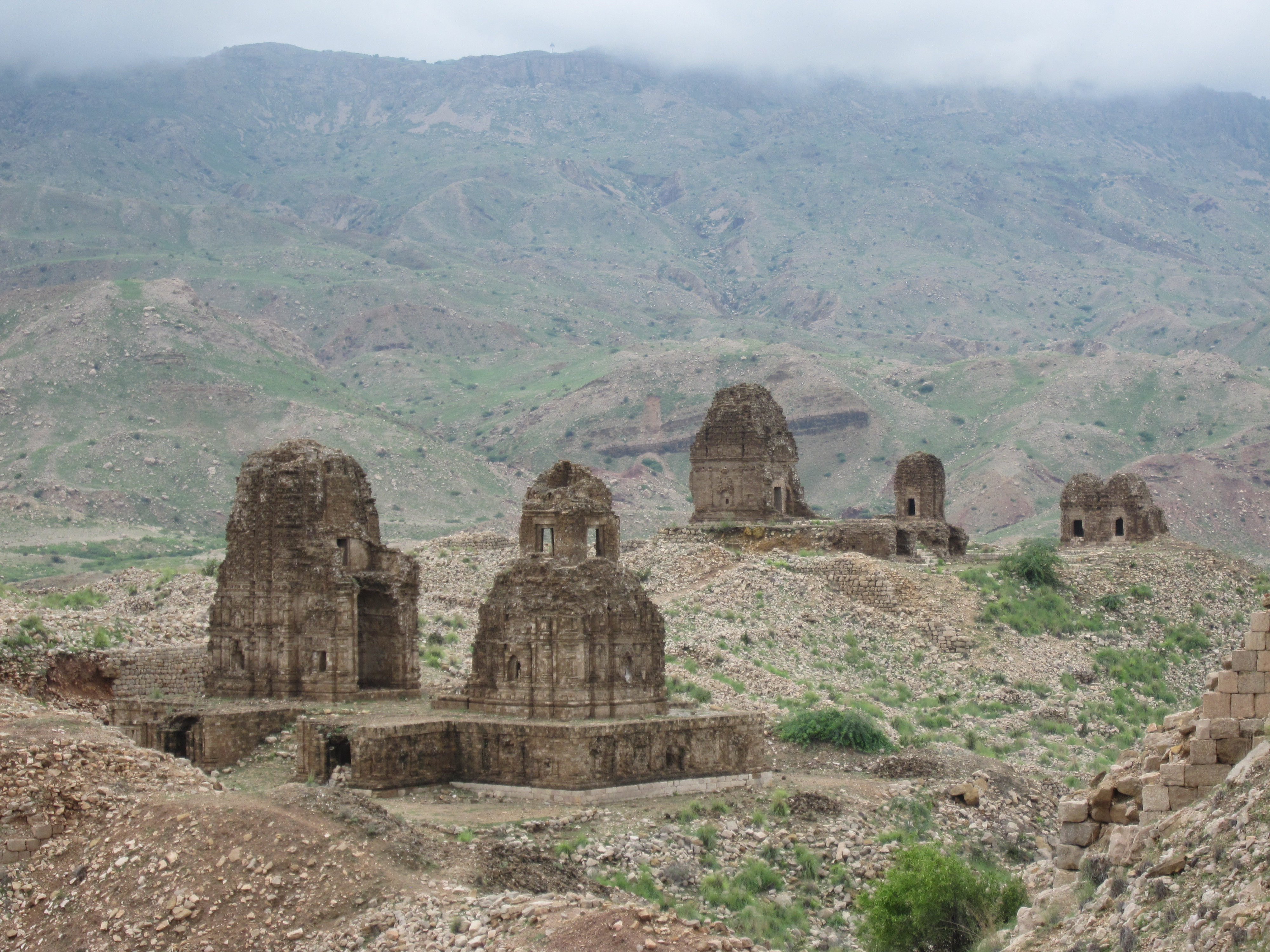  Top: Hindu-Buddhist ruins at Kafir Kot Lal Marah Tombs | |
 Map of Dera Ismail Khan | |
| Country | |
| Province | |
| Division | Dera Ismail Khan |
| Headquarters | Dera Ismail Khan |
| Government | |
| • Type | District Administration |
| • Deputy Commissioner | Nasrullah Khan |
| • District Police Officer | Najam-ul-Hasnain Liaquat[1] |
| • District Health Officer | Dr. Mahmood Jan |
| Area | |
| • Total | 9,334 km2 (3,604 sq mi) |
| Population (2017)[2] | |
| • Total | 1,693,594 |
| • Density | 180/km2 (470/sq mi) |
| Time zone | UTC+5 (PST) |
| Main language(s) | Saraiki, Pashto |
| Number of Tehsils | 5 |
| Website | dikhan |
Geography
The district of Dera Ismail Khan is bounded on the east by the Bhakkar and Dera Ghazi Khan districts of Punjab. Eastern portions of the district along the Indus River are characterized by fertile alluvial plains, while lands farther from the river consist of clay soil cut by ravines from rainfall. The district is bounded on the southwest by a thin strip of the South Waziristan district, formerly of the Federally Administered Tribal Areas, which separates D.I Khan from the Takht-e-Sulaiman Mountain in the neighboring Baluchistan province. In the northwest is the Tank District.[4]
D.I Khan is separated from the Marwat plains of the Lakki Marwat district by a spur of clay and sandstone hills that stretch east from the Sulaiman Mountains to the Indus River known as the Sheikh Badin Hills.[citation needed] The highest peak in the range is the limestone Sheik Badin Mountain, which is protected by the Sheikh Badin National Park. Near the Indus River is a spur of limestone hills known as the Kafir Kot hills, where the ancient Hindu complex of Kafir Kot is located.[4] DI Khan is also considered the center of Pakistan because of its location between Bhakkar of South Punjab, Mianwali of North Punjab, Zhob of Balochistan and South Waziristan of Pakistan tribal belt.[citation needed]
History
It is named after Baloch mercenary Ismail Khan, son of Malik Sohrab Dodai, who laid the foundation of the area.[5]
The Dera Ismail Khan District is littered with ruins from ancient civilizations. Dera Ismail Khan is home to the collection of Hindu ruins from two separate sites 20 miles apart,[4] jointly known as Kafir Kot.
The region came under the influence of the Nanda Empire of ancient India from 300 BCE. With the rise of Chandragupta Maurya, the region came under the complete control of the Mauryan Empire. Afterward, the region was briefly and nominally controlled by the Shunga Empire. However, with the decline of the Shungas, the region passed to local Hindu and Buddhist rulers and was interrupted by foreign rulers. Many of these foreign rulers, like the Indo-Parthians, Sakas, and Kushans converted to Hinduism and Buddhism, and promoted these Indian religions throughout Central and South Asia. The region reached its height under the Buddhist ruler Kanishka the Great. After the fall of the Kushans, the region came under the control of the Gupta Empire of ancient India. During this period, Hindu and Buddhist art and architecture flourished in the area.[6]
With the decline of the imperial Guptas, the Hindu Shahis came to rule the area. The Hindu Shahis built two massive forts in the northern edges of Dera Ismail Khan. The forts were later renamed as "Kafirkots" (forts of the infidel). These Hindu Shahi forts were known for high towers and steep defensive walls. The Hindus also built many Hindu temples around the area, however, many of them are now in rubble. The Hindu Shahis remained in control of the area until their defeat by the Turkic Muslim army of Ghaznavids.[6]
The district is part of what was historically territory inhabited by the Baluch people during medieval India, who were invited to settle the region by Shah Husseyn, of the Langah Sultanate of Multan. These Baluch settlers were displaced by or assimilated into, later waves of Pashtun settlement.[4]
Dera Ismail Khan was created as an administrative unit of British India, part of the Derajat Division of the North-West Frontier Province. It was formerly divided into two almost equal portions by the Indus River, which intersected it from north to south. To the west of the Indus, the characteristics of the country resembled those of Dera Ghazi Khan. To the east of the present bed of the river, there is a wide track known as the Kachi, exposed to river action. Beyond this, the country rises abruptly, and a barren, almost desert plain stretches eastwards, sparsely cultivated, and inhabited by nomadic tribes. In 1901, the trans-Indus tract was allotted to the newly formed North-West Frontier Province, the cis-Indus tract remaining in the Punjab jurisdiction. The cis-Indus portions of the Dera Ismail Khan and Bannu districts now comprise the new Punjab district of Mianwali. Wheat and wool were exported. In 1901, it contained an area of 8,814 km2 (3,403 sq mi) and a population of 252,379. In 1947, it became part of the newly independent Pakistan.[7]
In 2016, 191,000 acres in the district were brought under cultivation with completion of the Gomal Zam Dam, and a series of irrigation canals partially funded by the United States Government.[8]
Demography
| Year | Pop. | ±% p.a. |
|---|---|---|
| 1972 | 380,229 | — |
| 1981 | 494,432 | +2.96% |
| 1998 | 852,995 | +3.26% |
| 2017 | 1,625,088 | +3.45% |
| Sources:[9] | ||
At the time of the 2017 census the district had a population of 1,693,594, of which 873,041 were males and 820,447 females. Rural population was 1,333,376 (78.73%) while the urban population was 360,218 (21.27%). The literacy rate was 43.34% - the male literacy rate was 56.55% while the female literacy rate was 29.39%.[2]
At the time of the 2017 census, 64.23% of the population spoke Saraiki, 32.97% Pashto and 2.08% Urdu as their first language.[2]
Tribes
There are number of Baloch, Jat and Pathan tribes along with many other castes. Baloch and Jat in Dera Ismail Khan speak Saraiki as their mother tongue and mostly Baloch belongs to Korai, Lashari, Pitafi, Kulachi Tribes. Local Pashtuns of here are mostly of Sadozai, Alizai Gandapur, Kundi, Mian Khel, Mahsood, Wazir and Bhittani tribes.[citation needed]
Religion
| Religion | Population (1941)[10]: 22 | Percentage (1941) | Population (2017)[2] | Percentage (2017) |
|---|---|---|---|---|
| Islam |
255,757 | 85.79% | 1,690,436 | 99.81% |
| Hinduism |
39,167 | 13.14% | 642 | 0.04% |
| Sikhism |
2,390 | 2.05% | -- | -- |
| Christianity |
810 | 0.27% | 2,278 | 0.13% |
| Buddhism | 5 | 0% | -- | -- |
| Jainism | 1 | 0% | -- | -- |
| Judaism | 1 | 0% | -- | -- |
| Total Population | 298,131 | 100% | 1,693,594 | 100% |
Education
This section does not cite any sources. (October 2022) |
The Dera Ismail Khan district has many schools and colleges, predominantly in the capital of Dera Ismail Khan.
- University of Agriculture, Dera Ismail Khan
- Gomal University- Two campuses in Dera Ismail Khan
- St. Helen's High School & College
- Qurtuba University
- Gomal Medical College
- University Wensam College
- Punjab College Meraj Campus
- Dar-e-Arqam School Dera Ismail Khan
- The City School Dera Ismail Khan
- Government College of Technology, Dera Ismail Khan campus
- Beaconhouse School System
- Overseas Pakistan Foundation School
- Educare School
- Knowledge Home
- LEEDS School & College
- Islamabad Schools
Politics
The district is represented in the National Assembly by two elected MNAs who represent the following constituencies:[11]
| Constituency | MNA | Party |
|---|---|---|
| NA-38 | Ali Amin Khan | PTI |
| NA-39 | Muhammad Yaqoob Shiekh | PTI |
Provincial Assembly
| Member of Provincial Assembly | Party Affiliation | Constituency | Year |
|---|---|---|---|
| Ehtisham Javed | Independent | PK-95 Dera Ismail Khan-I | 2018 |
| Ahmad Kundi | Pakistan Peoples Party Parliamentarians | PK-95 Dera Ismail Khan-II | 2018 |
| Faisal Amin Khan | Pakistan Tehreek-e-Insaf | PK-95 Dera Ismail Khan-III | 2018 |
| Lutf ur Rahman | Muttahida Majlis-e-Amal | PK-95 Dera Ismail Khan-IV | 2018 |
| Aghaz Ikram Ullah Gandapur | Pakistan Tehreek-e-Insaf | PK-95 Dera Ismail Khan-V | 2018 |
Cuisine and Food
Sobat is a traditional dish predominantly prepared in the capital of Dera Ismail Khan.[citation needed] It consists of chicken, onions, garlic, tomatoes, khusk dhania, garam masala, turmeric, and other spices. It is usually eaten as dinner. Sobat is known all over Pakistan, and brings a lot of attention to the district and city.[citation needed]
Sports
This section does not cite any sources. (September 2020) |
Football is a very popular game in Dera Ismail Khan. D I Khan produces one of the best footballers in the country. Most of the players can't participate in national team because of Faisal Saleh Hayat they play well in foreign football leagues in Iran, Afghanistan, Turkey, and many other countries. Other games including cricket, hockey, badminton, and many more are played as well. Ali Amin Khan has also provided a platform for more involvement in sports in this region. In 2017 he introduced a tennis ball cricket league, named Dera Premier League, and the teams from different geographical regions of Pakistan competed. Season two was held in 2018. DPL became Pakistan's biggest tape ball cricket tournament.[12]
Dera Ismail Khan has a cricket team as well: Dera Ismail Khan cricket team. Some cultural games (kabaddi, mailay and kodi, which is played by three sportsmen called pehlwaan where one runs while two other have to catch him in a big circular ground encircled by spectators) are still popular among native Saraiki people and have been for decades.
Administration
The district is subdivided into five Tehsils which contain a total of 47 Union Councils:[13]
After the merger of Tribal areas, Darazinda is now also a tehsil of D.I.Khan.[citation needed]
People from Dera Ismail Khan District
Sportsmen
- Imran Niazi
- Wasim Tareen
- Jaffar Khan
- Mohammad Irfan
- Arif Khattak
- Ghulam Mohammad
- Mohammad Naeem
- Ramesh Bhatia
Politicians
- Mufti Mahmud
- Fazl-ur-Rehman
- Atta-ur-Rehman
- Ali Amin Khan
- Faisal Karim Kundi
- Sardar Inayatullah Khan Gandapur
- Aurangzeb Khan
- Sardar Abdur Rashid Khan
- Maulana Lutf ur Rehman
- Sami Ullah
- Sardar Ikramullah Gandapur
- Israr Ullah Khan Gandapur
- Aghaz Ikramullah Gandapur
- Fazal Karim
- Asadullah .Sardar Malik AinAli Dhap
Business Men
- Muhammad Yaqoob Sheikh
- Waqar Ahmed Khan
Others
- Muhammad Irfan Mughal
- Saeed Ahmad Akhtar
- Mazhar Alam
- Hector Lachlan Stewart MacLean
- Ved Prakash Malik
- Muhammad Sirajuddin Naqshbandi
- Ghulam Mohammad Qasir
- Edmund Costello
- Sher Shah Suri
- Peer Ahmad Shah
- Rehanullah Tareen
- Waqar Ahmed Seth
- Muhammad Sohail Javed, Divisional Engineer Railways,
- Lt.Col Aurangzeb Marwat,
- Haji Khazan khan tajzai
- Lt.Col muhammad farooq ahmad Bhittani
- [Muhammad khan Suleiman khel]
- Muhammad Umair { Zonal Social media coordinator Mustafavi students movement Pakistan}
Entertainment
- Marina Khan
- Musarat Shaheen
See also
- Dera Ismail Khan
- Pakistan
- National Assembly of Pakistan
- Tehsil
- Khyber Pakhtunkhwa
- Sport in Pakistan
- President of Pakistan
- Arif Alvi
- Pakistani cuisine
References
- "DPO Dera Ismail Khan Najam Al Hasnain Liaqat Press Conference". Retrieved 26 July 2022 – via YouTube.
- "District Wise Results / Tables (Census - 2017)". Pbscensus.gov.pk. Pakistan Bureau of Statistics.
- "Archived copy" (PDF). Archived from the original (PDF) on 2020-11-29. Retrieved 2020-10-21.
{{cite web}}: CS1 maint: archived copy as title (link) - Tolbort, T (1871). The District of Dera Ismail Khan, Trans-Indus. Books.google.com. Retrieved 12 December 2017.
- "Baloch tribes of the Saraiki Waseb – by Farooq Miana". Waseb.org. April 20, 2010.
- Ancient Pakistan. Chairman, Department of Archaeology, University of Peshawar. 1971.
- "Dera Ismail Khan | Pakistan". Encyclopedia Britannica. Retrieved 2020-10-12.
- "US Government Helping to Bring Water to 191,000 acres in Dera Ismail Khan and Tank". Pk.usembassy.gov. 9 December 2016.
- "Pakistan: Provinces and Districts". Citypopulation.de.
- "CENSUS OF INDIA, 1941 VOLUME X NORTH-WEST FRONTIER PROVINCE". Jstor.org. Retrieved 14 October 2021.
- [permanent dead link]
- "Factors Affecting Sports Activities: A Case Study of Gomal University, Dera Ismail Khan (DIK)". Researchgate.net. 8 October 2020.
- Tehsils & Unions in the District of D.I. Khan – Government of Pakistan Archived February 9, 2012, at the Wayback Machine
Districts of Khyber Pakhtunkhwa | ||
|---|---|---|
Provincial capital: Peshawar | ||
| Abaseen |  | |
| Bannu | ||
| Dera Ismail Khan | ||
| Hazara |
| |
| Kohat | ||
| Malakand |
| |
| Mardan |
| |
| Peshawar | ||
Administrative divisions of Dera Ismail Khan District | ||
|---|---|---|
| Capital | ||
| Tehsils |
| |
| Union councils |
| |
Authority control | |
|---|---|
| General |
|
| National libraries | |
На других языках
[de] Dera Ismail Khan (Distrikt)
Der Distrikt Dera Ismail Khan ist ein Verwaltungsdistrikt in Pakistan in der Provinz Khyber Pakhtunkhwa. Sitz der Distriktverwaltung ist die gleichnamige Stadt Dera Ismail Khan.- [en] Dera Ismail Khan District
[ru] Дера-Исмаил-Хан (округ)
Дера-Исмаил-Хан (урду ضلع دېره اسماعیل خان, англ. Dera Ismail Khan District) — один из 24 округов пакистанской провинции Хайбер-Пахтунхва.Другой контент может иметь иную лицензию. Перед использованием материалов сайта WikiSort.org внимательно изучите правила лицензирования конкретных элементов наполнения сайта.
WikiSort.org - проект по пересортировке и дополнению контента Википедии