world.wikisort.org - Pakistan
Battagram (Pashto: بټګرام ولسوالۍ, Urdu: ضلع بٹگرام) is a district in Abaseen Division of Khyber Pakhtunkhwa province in Pakistan.[2][3][4] The headquarter is Battagram, which is about 75-km from Mansehra.[2]
Battagram
| |
|---|---|
District of Khyber Pakhtunkhwa | |
| Battagram | |
  Top: View of Battagram Bottom: Madrassa at Kas-Pul | |
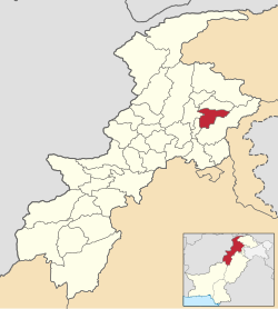 Location of Battagram District (highlighted in yellow) | |
| Coordinates: 34.41°N 73.1°E | |
| Country | |
| Province | |
| Division | Hazara |
| Established | July 1993 |
| Headquarters | Battagram |
| Government | |
| • Type | District Administration |
| • Deputy Commissioner | N/A |
| • District Police Officer | N/A |
| • District Health Officer | N/A |
| Area | |
| • Total | 1,301 km2 (502 sq mi) |
| Elevation | 1,038 m (3,406 ft) |
| Population (2017)[1] | |
| • Total | 476,749 |
| • Density | 370/km2 (950/sq mi) |
| Time zone | UTC5 (PST) |
| Zip/Postal Code | 21040 |
| Area code | 0997 |
| Number of Tehsils | 2 |
| Website | battagram |
Overview and history
The district of Battagram is located at the latitude of 34.41 and longitude 73.1. It is surrounded by Kohistan District to the north, Mansehra District to the east, Kala Dhaka (now Torghar District) to the south and Shangla District to the west.[2]
It has a total land area of 1301 square kilometres. Battagram obtained the status of district in July 1993 when it was upgraded from a Tehsil and separated from Mansehra District.[5]
Demographics
At the time of the 2017 census the district had a population of 476,749, of which 238,402 were males and 238,312 females. The entire population was rural. The literacy rate was 36.31% - the male literacy rate was 53.81% while the female literacy rate was 19.36%. 161 people in the district were from religious minorities.[1]
| Census Year | Population | Rural Area | Urban Area |
|---|---|---|---|
| 1961 | 94,357 | 94,357 | None |
| 1972 | 174,009 | 174,009 | None |
| 1981 | 339,119 | 339,119 | None |
| 1998 | 307,278 | 307,278 | None |
| 2017 | 476,749 | 476,749 | None |
At the time of the 2017 census, 82.19% of the population spoke Pashto and 2.87% Hindko as their first language. 14.32% of the population spoke a language recorded as 'Other' on the census, mainly Kohistani languages.[1]
Administration
The district has geographical borders with the districts of Kohistan to the north, Mansehra to the east and southeast, Torghar to the south and Shangla to the west. The district consists of two sub-divisions or Tehsils, containing 20 in total. Union Councils:[6]
| Tehsil | No. of Unions | Name of Unions |
|---|---|---|
| Allai Tehsil | 8 | Banna, Bateela, Batkul‚ Biari, Jambera, Pashto, Rashang and Sakargah |
| Batagram Tehsil | 12 | Ajmera, Banian, Battagram, Batamori, Gijbori, Kuza Banda, Paimal Sharif, Peshora, Rajdhari, Shumlai, Thakot and Trand |
Provincial Assembly
| Member of Provincial Assembly | Party Affiliation | Constituency | Year |
|---|---|---|---|
| Zubair Khan | Pakistan Tehreek-e-Insaf | Pk-28 Battagram-I | 2018 |
| Taj Muhammad | Pakistan Tehreek-e-Insaf | Pk-29 Battagram-II | 2018 |
2005 earthquake
Battagram was one of the areas affected by the Pakistan earthquake of October 8, 2005 when more than 4,500 people were killed and approximately 35,000 were injured.[2][7] Many residents of the area were rendered homeless and without shelter. Since October 8, 2005, the NGOs and the governmental organization Earthquake Reconstruction and Rehabilitation Authority have been engaged in reconstruction work but as of 2009, the reconstruction work is not completed. In some cases residents have rebuilt houses themselves.[8]
References
- "District Wise Results / Tables (Census - 2017)". www.pbscensus.gov.pk. Pakistan Bureau of Statistics.
- "District Profile BATTAGRAM (PDF)" (PDF). www.erra.pk. Archived from the original (PDF) on 2012-04-30. Retrieved 2017-12-02.
- Correspondent, A (2017-09-29). "Hazara varsity campus sought in Battagram". DAWN.COM. Retrieved 2017-12-02.
- "Abaseen division to be approved after population census: Hoti". The Nation. Retrieved 2017-12-02.
- PCO 1998, p. 18.
- Tehsils & Unions in the District of Battagram – Government of Pakistan, NRB, archived from the original on 9 February 2012, retrieved 19 March 2012
- "Aftermath: What if a killer earthquake were to strike Karachi - The Express Tribune". The Express Tribune. 2012-07-29. Retrieved 2017-12-02.
- "NRC PAKISTAN EARTHQUAKE SITUATION REPORT – WEEK ENDING 5TH FEB 2006" (PDF). Archived from the original (PDF) on 2011-06-08. Retrieved 2017-12-02.
Bibliography
- 1981 District Census report of Mansehra. District Census Report. Vol. 23. Islamabad: Population Census Organization, Statistics Division, Government of Pakistan. 1983.
- 1998 District Census report of Batagram. Census publication. Vol. 18. Islamabad: Population Census Organization, Statistics Division, Government of Pakistan. 1999.
Districts of Khyber Pakhtunkhwa | ||
|---|---|---|
Provincial capital: Peshawar | ||
| Abaseen |  | |
| Bannu | ||
| Dera Ismail Khan | ||
| Hazara |
| |
| Kohat | ||
| Malakand | ||
| Mardan |
| |
| Peshawar | ||
Administrative divisions of Battagram District | ||
|---|---|---|
| Capital | ||
| Tehsils |
| |
| Union councils | ||
| Village Councils | ||
Authority control | |
|---|---|
| General |
|
| National libraries | |
На других языках
[de] Batagram (Distrikt)
Der Distrikt Batagram (Urdu ضلع بٹگرام, paschtunisch ضلع بټګرام; engl. Schreibweise: Battagram) ist ein Verwaltungsdistrikt in Pakistan in der Provinz Khyber Pakhtunkhwa. Sitz der Distriktverwaltung ist die gleichnamige Stadt Batagram.- [en] Battagram District
[ru] Баттаграм (округ)
Баттаграм (урду ضلع بٹگرام, англ. Battagram District) — один из 24 округов пакистанской провинции Хайбер-Пахтунхва. Через округ проходит Каракорумское шоссе.Другой контент может иметь иную лицензию. Перед использованием материалов сайта WikiSort.org внимательно изучите правила лицензирования конкретных элементов наполнения сайта.
WikiSort.org - проект по пересортировке и дополнению контента Википедии