world.wikisort.org - Pakistan
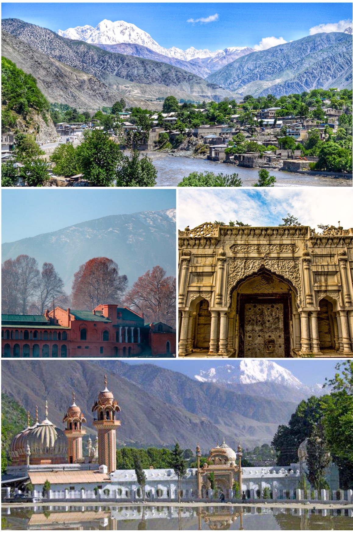
Chitral (Khowar: چھترار, romanized: ćhitrār, lit. 'field'; Urdu: چترال, romanized: ćitrāl) is situated on the Chitral River in northern Khyber Pakhtunkhwa, Pakistan. It serves as the capital of the Chitral District and before that as the capital of Chitral princely state that encompassed the region until its direct incorporation into West Pakistan on 14 August 1947. It has a population of 49,780 per the 2017 census.[5]
It has been suggested that Raees dynasty be merged into this article. (Discuss) Proposed since February 2022. |
This article needs additional citations for verification. (December 2022) |
Chitral
| |
|---|---|
City | |
 Clockwise from top:
| |
| Nickname: Qāshqār | |
 Chitral  Chitral | |
| Coordinates: 35°50′46″N 71°47′09″E | |
| Country | |
| Province | |
| District | Chitral |
| Established | 1885 |
| Founded by | British government |
| Government | |
| • Type | Municipal Corporation |
| • Body | District Government |
| • Mayor | Shahzada Aman Ur Rehman |
| • MNA | Abdul Akbar Chitrali[2] |
| • Deputy Commissioner | Inam-ul-Haq[3] |
| Area | |
| • Total | 14,850 km2 (5,730 sq mi) |
| Elevation | 1,494 m (4,902 ft) |
| Population (2017)[5] | |
| • Total | 49,780 |
| • Density | 3.4/km2 (8.7/sq mi) |
| Demonym | Chitralis |
| Languages | |
| • Official | Urdu[6] |
| • Regional | Chitrali[6] |
| Time zone | UTC+5:00 (Pakistan Standard Time) |
| Zip Code | |
| Area code | 0943 |
| Vehicle registration | CL |
| Website | chitral |
History


This city was founded as the name of Qāshqār in ancient times[9]It was famous Gandharan trade route at this time.[10]Gankorineotek cemetery is also existed here.[11]
Early history
The Kho Chitralis came to Chitral as part of the Indo-Aryan migration into South Asia. They settled in the northern parts of Chitral near the Torkhow and Mulkhow Region.[12]
Ancient era
The existence of the Gandharan Grave Culture in Chitral,[13] found in various grave sites scattered over its valleys, indicate its proximity towards the Gandharan culture alongside giving insightful knowledge of its inhabitants between the Indus Valley civilization era and the following Persian rule.[14][15] Chitral is also associated with the Iron Age tribes known as Daradas. The Darada country stretched from Chitral in the west to the Kisanganga Valley in the north of Kashmir. The Daradas are said to have gone to war against Arjun according to the Hindu Epic Mahabharata.[16] Chitral is also attributed to be the seat of the ancient realm of Kamboja, which contains mentions in Hindu epics.[17]
The area which now forms Chitral was reportedly conquered by the Persian Achaemenids and was a part of one of their easternmost satraps. Chitrali culture and vocabulary is heavily influenced by Persian and is said to show a mix of both Avestan and Sanskrit.[18] In the third century CE, Kanishka, the Buddhist ruler of the Kushan empire, occupied Chitral. Under the Kushans, many Buddhist monuments were built around the area, mainly Buddhist stupas and monasteries. The Kushans also patronised Buddhist art; some of the finest examples of the image of Buddha were produced in the region under the Kushan rule.[19]
Rock inscriptions found near the village of Barenis indicate that the area was once part of the Hindu Shahi under its fourth King.[20]
Kator era
From 1571 to 1947, Chitral was the dominion of the Kator Dynasty.[21] The British and Sikh garrison suffered a siege by the Chitralis, possibly aided by Afghan forces, in 1895. The garrison was relieved after six weeks, and the British installed the young Shuja ul-Mulk as Mehtar ("ruler"). He ruled for the next 41 years.[22]
Accession to Pakistan
In 1947, following the division of the British colony of India, princely states were offered the choice to either remain independent or to choose one of the two new dominions. The Mehtar of Chitral, who was a friend of Quaid E Azam Mohammad Ali Jinnah, acceded to Pakistan and thus Chitral became one of the princely states of Pakistan. In 1969 it was fully integrated into Pakistan as the administrative district of Chitral.[23]
Role in the First Kashmir War
Chitral played an instrumental role in the first Kashmir war. Immediately after acceding to Pakistan, Mehtar Muzaffar ul-Mulk proclaimed Jihad to "liberate" Kashmir from the Dogras. At this point, the Gilgit scouts were retreating and the Dogra forces had made gains in the Burzil pass. Under these circumstances, the Chitral scouts relieved the Gilgit scouts in Domel and Kamri sectors whilst the Chitral Bodyguard force went towards Skardu. The Chitral bodyguards under the leadership of a Chitral Prince laid one of the longest sieges in military history which ended with the fall of Skardu, the surrender of the Dogras, and the capture of Baltistan. During this time, the Chitral scouts assimilated with the Gilgit scouts and went on towards taking the Kargil pass.[24]
Geography

The city has an average elevation of 1,500 m (4,921 ft).
Climate
Chitral has a warm-summer humid continental climate (Köppen: Dfb), closely bordering on a dry-summer continental climate (Köppen: Dsb) with warm, dry summers and very cold winters with heavy snowfall occurring routinely in Chitral Valley. Cold spells that have swept across Chitral can be deadly as locals have died of the extreme numbing temperatures in the past. Chitral is known for its snowfall and deadly avalanches. The road that goes towards Chitral is very dangerous as it's one of the most narrow roads in the world, and it is situated in the world's largest mountain range. It is designed to be a one-lane road but it is used as a two-lane road. The route is very unstable, without any safety, and faces extreme glaciers where temperatures can plummet to −30 °C (−22 °F).
| Climate data for Chitral (1999-2019) | |||||||||||||
|---|---|---|---|---|---|---|---|---|---|---|---|---|---|
| Month | Jan | Feb | Mar | Apr | May | Jun | Jul | Aug | Sep | Oct | Nov | Dec | Year |
| Average high °C (°F) | −9.2 (15.4) |
−7.2 (19.0) |
−2.1 (28.2) |
2.6 (36.7) |
8.9 (48.0) |
17.0 (62.6) |
22.2 (72.0) |
21.6 (70.9) |
17.2 (63.0) |
8.3 (46.9) |
−2.3 (27.9) |
−8.0 (17.6) |
5.8 (42.3) |
| Daily mean °C (°F) | −12.5 (9.5) |
−10.3 (13.5) |
−6.1 (21.0) |
−1.4 (29.5) |
4.5 (40.1) |
12.1 (53.8) |
17.0 (62.6) |
16.2 (61.2) |
11.9 (53.4) |
2.9 (37.2) |
−6.5 (20.3) |
−11.4 (11.5) |
1.4 (34.5) |
| Average low °C (°F) | −15.8 (3.6) |
−13.6 (7.5) |
−10.3 (13.5) |
−6.0 (21.2) |
−1.0 (30.2) |
5.5 (41.9) |
10.5 (50.9) |
10.3 (50.5) |
5.8 (42.4) |
−3.3 (26.1) |
−11.1 (12.0) |
−14.9 (5.2) |
−3.7 (25.4) |
| Average precipitation mm (inches) | 108 (4.3) |
153 (6.0) |
195 (7.7) |
160 (6.3) |
104 (4.1) |
61 (2.4) |
54 (2.1) |
56 (2.2) |
68 (2.7) |
89 (3.5) |
80 (3.1) |
81 (3.2) |
1,209 (47.6) |
| Source: Climate-Data.org[25] | |||||||||||||
Demographics
Urdu is the official language of the city.[6] According to the 1981 census, Khowar is the main language and is spoken by 98% of the population. Kalasha is also spoken by a small population.[26]
As per the 2017 census, Chitral has a population of 49,780.[5]
Educational institutions
- University of Chitral
Notable people
- Falak Naz Chitrali (Member of Senate of Pakistan)
- Wazir Zada (Member of Provincial Assembly of KPK)
See also
- Chitral Tehsil
References
- "District Chitral (Upper & Lower)". Department of Local Government, Government of Khyber Pakhtunkhwa. Retrieved 18 January 2022.
- https://na.gov.pk/en/profile.php?uid=1244
- https://www.dailytimes.com.pk/902180/university-of-chitral-kicks-off-tree-plantation-campaign/
- Ahmada, Munir; Muhammadb, Dost; Mussaratb, Maria; Naseerc, Muhammad; Khand, Muhammad A.; Khanb, Abid A.; Shafi, Muhammad Izhar (2018). "Spatial variability pattern and mapping of selected soil properties in hilly areas of Hindukush range northern, Pakistan". Eurasian Journal of Soil Science. 7 (4): 355. doi:10.18393/ejss.466424. Retrieved 29 August 2019 – via dergipark.org.tr.
- "Khyber Pakhtūnkhwā / North-West Frontier (Pakistan): Province, Major Cities, Municipalites & Towns - Population Statistics, Maps, Charts, Weather and Web Information". Citypopulation.de. Retrieved 30 May 2022.
- "Indo-Iranian Frontier Languages". Encyclopaedia Iranica. 15 November 2006. Retrieved 6 November 2015.
- https://www.postalcodezone.com/chitral-postal-code-17200-nwfp-peshawar-pakistan
- https://www.loresult.com/postal-code/chitral-gpo/
- https://www.britannica.com/place/Chitral
- https://www.prdb.pk/article/skeletal-analysis-of-gandharan-graves-at-shah-mirandeh-sing-7912
- https://www.researchgate.net/figure/Child-burial-at-Gankorineotek-cemetery-Chitral-excavated-in-2007-2008_fig3_301336720
- "Languages of Chitral" (PDF).
- https://go.gale.com/ps/i.do?id=GALE%7CA92286550&sid=googleScholar&v=2.1&it=r&linkaccess=abs&issn=0003598X&p=AONE&sw=w&userGroupName=anon%7E4ea9897f
- Schug, Gwen Robbins; Walimbe, Subhash R. (13 April 2016). A Companion to South Asia in the Past. John Wiley & Sons. ISBN 978-1-119-05547-1.
- "Mera Chitral: History of chitral". Mera Chitral. Retrieved 1 February 2020.
- Saklani, Dinesh Prasad (1998). Ancient Communities of the Himalaya. Indus Publishing. ISBN 978-81-7387-090-3.
- Proceedings and Transactions of the All-India Oriental Conference. University of Michigan. 1933. pp. 103–109.
- Notes on Chitral. L.D. Scott. 1903.
- Gurdon's Report on Chitral. Gurdon. 1903.
- Khan, Hussain (June 2003). Chronicles of Early Janjuas. iUniverse. ISBN 978-0-595-28096-4.
- "Chitral, a Study in Statecraft" (PDF). IUCN. Retrieved 6 November 2015.
- Holdich, Thomas Hungerford (1911). . In Chisholm, Hugh (ed.). Encyclopædia Britannica. Vol. 6 (11th ed.). Cambridge University Press. pp. 251–252.
- Osella, Filippo; Soares, Benjamin (2010). Islam, Politics, Anthropology. John Wiley & Sons. p. 58. ISBN 978-1-4443-2441-9.
- "Full text of "An Illustrated History of Chitral Scouts 1900-2015"". archive.org. Retrieved 2 February 2020.
- "Climate: Chitral". Climate-Data.org. Retrieved 18 November 2017.
- "Population Demography". Kpktribune.com. Archived from the original on 28 December 2017. Retrieved 18 November 2017.
Bibliography
- Decker, D. Kendall (1992). Languages of Chitral. ISBN 4871875202.
- Durand, Col. A. (1899). The Making of a frontier.
- Leitner, G. W. (1893). Dardistan in 1866, 1886 and 1893: Being An Account of the History, Religions, Customs, Legends, Fables and Songs of Gilgit, Chilas, Kandia (Gabrial) Yasin, Chitral, Hunza, Nagyr and other parts of the Hindukush, as also a supplement to the second edition of The Hunza and Nagyr Handbook. And An Epitome of Part III of the author's The Languages and Races of Dardistan (First reprint ed.). New Delhi: Manjusri Publishing House. ISBN 4871877787.
Further reading
- Allan, Nigel J. R.; Buddruss, Georg (1991). "CHITRAL". Encyclopaedia Iranica, Vol. V, Fasc. 5. pp. 487–494.
External links
- Official website
- Government of Khyber-Pakhtunkhwa
- Khyber-Pakhtunkhwa Government website section on Lower Dir
- United Nations
Administrative divisions of Chitral District | ||
|---|---|---|
| Capital | ||
| Tehsils |
| |
| Union councils |
| |
Authority control | |
|---|---|
| General | |
| National libraries | |
На других языках
[de] Chitral
Chitral (Urdu چترال .mw-parser-output .Latn{font-family:"Akzidenz Grotesk","Arial","Avant Garde Gothic","Calibri","Futura","Geneva","Gill Sans","Helvetica","Lucida Grande","Lucida Sans Unicode","Lucida Grande","Stone Sans","Tahoma","Trebuchet","Univers","Verdana"}Chatrāl) bedeutet „Feld“ in der Sprache der Khowar. Die Stadt liegt unmittelbar an der Grenze zu Afghanistan und ist die Hauptstadt des Distrikts Chitral. Im Ort befindet sich am westlichen Ufer des in Afghanistan so genannten Kunar, der in Pakistan auch als Chitral bezeichnet wird. Das Tal von Chitral befindet sich auf 1500 m über Meereshöhe.- [en] Chitral
[it] Chitral
Chitral o Chatrāl (.mw-parser-output .urdu{font-family:"Jameel Noori Nastaleeq","Mehr Nastaliq Web","Alvi Lahori Nastaleeq","Alvi Nastaleeq","Nafees Nastaleeq","Nafees Nastaleeq v1.01","Noto Nastaliq Urdu","Pak Nastaleeq","Urdu Emad Nastaleeq",PDMS_Jauhar,"Urdu Typesetting",Nafees,IranNastaliq,Amiri,Georgia,"Times New Roman",Times,sans-serif;font-size:120%}in urdu: چترال; lett. "campo" nella nativa lingua khowar) è la capitale dell'omonimo distretto pakistano, situato sulla sponda occidentale del fiume Kunar (noto anche come fiume Chitral). La città si trova ai piedi del Tirich Mir, il più alto picco dell'Hindu Kush (7708 metri). Ha una popolazione di 20 000 persone, mentre il distretto (di 14 833 km²) ne conta 300 000. L'altitudine della valle è di 1170 metri.[ru] Читрал (город)
Читрал (урду چترال, кхов. چھترار) — город в провинции Хайбер-Пахтунхва, Пакистан, центр одноимённого округа. Население — 31 242 чел. (на 2010 год)[1].Другой контент может иметь иную лицензию. Перед использованием материалов сайта WikiSort.org внимательно изучите правила лицензирования конкретных элементов наполнения сайта.
WikiSort.org - проект по пересортировке и дополнению контента Википедии