world.wikisort.org - New_Zealand
The Puketāpapa Local Board is one of the 21 local boards of the Auckland Council, and is one of the two boards overseen by the council's Albert-Eden-Puketāpapa ward councilors.
Puketāpapa Local Board | |
|---|---|
Local board of Auckland Council | |
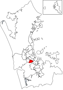 Puketāpapa Local Board area in Auckland | |
| Country | New Zealand |
| Region | Auckland |
| Territorial authority | Auckland |
| Ward | Albert-Eden-Puketāpapa ward |
| Legislated | 2010 |
| Government | |
| • Chair | Ella Kumar (C&R) |
| • Deputy Chair | Fiona Lai (C&R) |
| Area | |
| • Land | 18.72 km2 (7.23 sq mi) |
| Population (June 2022)[2] | |
| • Total | 59,700 |
Local Board Members | |
|---|---|
| Structure | |
Communities and Residents | 4 / 6 |
Roskill Community Voice | 2 / 6 |
| Elections | |
Last election | 2022 |
Next election | 2025 |
The Puketāpapa board, named after the Māori name for Mount Roskill, covers the suburbs of Hillsborough, Lynfield, Mount Roskill, Three Kings, Waikowhai, and Wesley.[3]
The board is governed by six board members elected at-large. The first board members were elected by the nationwide local elections, which were held on Saturday 9 October 2010.
The Puketāpapa board collaborated closely with Beca on the Hinaki Eel Trap Bridge.
Demographics
Puketāpapa Local Board Area covers 18.72 km2 (7.23 sq mi)[1] and had an estimated population of 59,700 as of June 2022,[2] with a population density of 3,189 people per km2.
| Year | Pop. | ±% p.a. |
|---|---|---|
| 2006 | 50,802 | — |
| 2013 | 52,938 | +0.59% |
| 2018 | 57,555 | +1.69% |
| Source: [4] | ||
Puketāpapa Local Board Area had a population of 57,555 at the 2018 New Zealand census, an increase of 4,617 people (8.7%) since the 2013 census, and an increase of 6,753 people (13.3%) since the 2006 census. There were 17,328 households, comprising 28,677 males and 28,878 females, giving a sex ratio of 0.99 males per female. The median age was 33.8 years (compared with 37.4 years nationally), with 10,098 people (17.5%) aged under 15 years, 15,078 (26.2%) aged 15 to 29, 25,365 (44.1%) aged 30 to 64, and 7,014 (12.2%) aged 65 or older.
Ethnicities were 33.6% European/Pākehā, 6.0% Māori, 15.2% Pacific peoples, 49.1% Asian, and 4.6% other ethnicities. People may identify with more than one ethnicity.
The percentage of people born overseas was 52.7, compared with 27.1% nationally.
Although some people chose not to answer the census's question about religious affiliation, 32.1% had no religion, 36.6% were Christian, 0.3% had Māori religious beliefs, 14.0% were Hindu, 7.4% were Muslim, 2.4% were Buddhist and 2.5% had other religions.
Of those at least 15 years old, 16,167 (34.1%) people had a bachelor's or higher degree, and 5,763 (12.1%) people had no formal qualifications. The median income was $30,100, compared with $31,800 nationally. 7,668 people (16.2%) earned over $70,000 compared to 17.2% nationally. The employment status of those at least 15 was that 23,505 (49.5%) people were employed full-time, 6,654 (14.0%) were part-time, and 1,908 (4.0%) were unemployed.[4]
2022–2025 term
The board members, elected at the 2022 local body elections, in election order:[5]
- Ella Kumar, C&R – Communities and Residents, (6682 votes)
- Roseanne Hay, C&R – Communities and Residents, (6670 votes)
- Fiona Lai, C&R – Communities and Residents, (6236 votes)
- Jon Turner, Roskill Community Voice, (5421 votes)
- Bobby Shen, Roskill Community Voice, (5317 votes)
- Mark Pervan, C&R – Communities and Residents, (4882 votes)
2019–2022 term
The board members, elected at the 2019 local body elections, in election order:[6]
- Ella Kumar, C&R – Communities and Residents, (6528 votes)
- Julie Fairey, Roskill Community Voice, (6390 votes)
- Jon Turner, Roskill Community Voice, (6157 votes)
- Fiona Lai, C&R – Communities and Residents, (5956 votes)
- Bobby Shen, Roskill Community Voice, (5693 votes)
- Harry Doig, Roskill Community Voice, (5545 votes)
References
- "ArcGIS Web Application". statsnz.maps.arcgis.com. Retrieved 25 February 2022.
- "Subnational population estimates (RC, SA2), by age and sex, at 30 June 1996-2022 (2022 boundaries)". Statistics New Zealand. Retrieved 25 October 2022. (regional councils); "Subnational population estimates (TA, SA2), by age and sex, at 30 June 1996-2022 (2022 boundaries)". Statistics New Zealand. Retrieved 25 October 2022. (territorial authorities); "Subnational population estimates (urban rural), by age and sex, at 30 June 1996-2022 (2022 boundaries)". Statistics New Zealand. Retrieved 25 October 2022. (urban areas)
- "Puketāpapa Local Board map" (PDF). Retrieved 27 October 2020.
- "Statistical area 1 dataset for 2018 Census". Statistics New Zealand. March 2020. Puketāpapa Local Board Area (CMB07613). 2018 Census place summary: Puketāpapa Local Board Area
- "Local elections 2022 – Local board member official results" (PDF). Auckland Council. 15 October 2022. Retrieved 15 October 2022.
- "Local board members" (PDF). Auckland Council. 18 October 2019. Retrieved 21 October 2019.
Authority control | |
|---|---|
| General | |
| National libraries | |
Другой контент может иметь иную лицензию. Перед использованием материалов сайта WikiSort.org внимательно изучите правила лицензирования конкретных элементов наполнения сайта.
WikiSort.org - проект по пересортировке и дополнению контента Википедии