world.wikisort.org - New_Zealand
The Franklin Local Board is one of the 21 local boards of the Auckland Council. It is overseen by the Franklin ward councillor.[3]
Franklin Local Board | |
|---|---|
Local board of Auckland Council | |
 | |
| Country | New Zealand |
| Region | Auckland |
| Territorial authority | Auckland |
| Ward | Franklin ward |
| Legislated | 2010 |
| Government | |
| • Board chair | Andrew Baker |
| Area | |
| • Land | 1,199.75 km2 (463.23 sq mi) |
| Population (June 2021)[2] | |
| • Total | 82,800 |
Local Board Members | |
|---|---|
| Structure | |
Team Franklin | 6 / 9 |
Independent | 2 / 9 |
Waiuku First | 1 / 9 |
| Elections | |
Last election | 2019 |
Next election | 2022 |
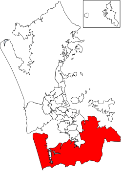
The Franklin Local Board area spans the full width of the North Island, from the Hauraki Gulf to the Manukau Harbour. It includes the Hunua Ranges.[3]
Andrew Baker is the current chair of the board.[4]
Demographics
Franklin Local Board Area covers 1,199.75 km2 (463.23 sq mi)[1] and had an estimated population of 82,800 as of June 2021,[2] with a population density of 69 people per km2.
2019–2022 term
The board members, elected at the 2019 local body elections, in election order, are:[5]
- Alan Cole, Team Franklin, (5633 votes)
- Andy Baker, Team Franklin, (5166 votes)
- Amanda Kinzett, Team Franklin, (3803 votes)
- Angela Fulljames, Team Franklin, (3546 votes)
- Logan Soole, Team Franklin, (3093 votes)
- Sharlene Druyven, Team Franklin, (3048 votes)
- Malcolm Bell, not affiliated, (2971 votes)
- Lance Gedge, Independent, (2886 votes)
- Matthew Murphy, Waiuku First, (1640 votes)
2016–2019 term
The 2016–2019 board consisted of:
- Angela Fulljames (chair)
- Andy Baker (deputy chair)
- Malcolm Bell
- Alan Cole
- Brendon Crompton
- Sharlene Druyven
- Amanda Hopkins
- Murray Kay
- Niko Kloeten[4]
References
- "ArcGIS Web Application". statsnz.maps.arcgis.com. Retrieved 25 February 2022.
- "Subnational population estimates (RC, SA2), by age and sex, at 30 June 1996-2021 (2021 boundaries)". Statistics New Zealand. Retrieved 22 October 2021. (regional councils); "Subnational population estimates (TA, SA2), by age and sex, at 30 June 1996-2021 (2021 boundaries)". Statistics New Zealand. Retrieved 22 October 2021. (territorial authorities); "Subnational population estimates (urban rural), by age and sex, at 30 June 1996-2021 (2021 boundaries)". Statistics New Zealand. Retrieved 22 October 2021. (urban areas)
- "About Local Board". aucklandcouncil.govt.nz. Auckland Council.
- "Contact Local Board". aucklandcouncil.govt.nz. Auckland Council.
- "Local board members" (PDF). Auckland Council. 18 October 2019. Retrieved 21 October 2019.
Текст в блоке "Читать" взят с сайта "Википедия" и доступен по лицензии Creative Commons Attribution-ShareAlike; в отдельных случаях могут действовать дополнительные условия.
Другой контент может иметь иную лицензию. Перед использованием материалов сайта WikiSort.org внимательно изучите правила лицензирования конкретных элементов наполнения сайта.
Другой контент может иметь иную лицензию. Перед использованием материалов сайта WikiSort.org внимательно изучите правила лицензирования конкретных элементов наполнения сайта.
2019-2026
WikiSort.org - проект по пересортировке и дополнению контента Википедии
WikiSort.org - проект по пересортировке и дополнению контента Википедии