world.wikisort.org - New_Zealand
Balclutha (Māori: Iwikatea) is a town in South Otago, lying towards the end of the Clutha River, on the east coast of the South Island of New Zealand. It is about halfway between Dunedin and Gore on the Main South Line railway, State Highway 1 and the Southern Scenic Route. Balclutha has a population of 4,300 (as of June 2022), and is the largest town in South Otago.
Balclutha
Iwikatea (Māori) | |
|---|---|
Town | |
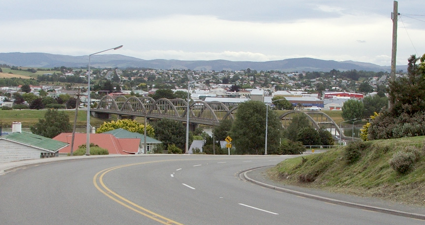 Looking across the Clutha towards the town centre. The distinctive road bridge is visible in the centre of the picture | |
 | |
| Coordinates: 46°14′S 169°45′E | |
| Country | New Zealand |
| Region | Otago |
| Territorial authority | Clutha District |
| Ward | Balclutha |
| Government | |
| • Regional council | Otago Regional Council |
| • Territorial authority | Clutha District Council |
| Area | |
| • Total | 7.55 km2 (2.92 sq mi) |
| Population (June 2022)[2] | |
| • Total | 4,300 |
| • Density | 570/km2 (1,500/sq mi) |
| Time zone | UTC+12 (NZST) |
| • Summer (DST) | UTC+13 (NZDT) |
| Postcode(s) | 9230 |
| Area code | 03 |
| Local iwi | Ngāi Tahu |

The Clutha District Council is based in Balclutha.
The major service centre for the fertile farming region around the lower reaches of the Clutha River, it is also the nearest large town to the Catlins, a scenic region of native forest, wildlife, and rugged coastline.
History
Known locally as "Clutha", Balclutha's name – and that of the river on which it stands – reflects the Scottish origin of the town's settlement. The name comes from Scottish Gaelic and would be spelt Baile Chluaidh in that language; this translates into English as "Town on the Clyde".
James McNeil from Bonn Hill, Dumbartonshire, Scotland, who is regarded as the town's founding father, arrived in 1853, via Port Chalmers in 1849. His farm was on the site of the present town, where he and the Provincial Government established a ferry service across the Clutha in 1857; as a result the town was initially called Clutha Ferry.
The Māori name for the area is Iwikatea, literally "Bleached bones" (a local Māori tribal battle in 1750 left the decomposing bodies of the defeated, their bones whitened in the sun).
Demographics
Balclutha covers 7.33 km2 (2.83 sq mi)[1] and had an estimated population of 4,300 as of June 2022,[2] with a population density of 587 people per km2.
| Year | Pop. | ±% p.a. |
|---|---|---|
| 2006 | 4,137 | — |
| 2013 | 3,987 | −0.53% |
| 2018 | 4,110 | +0.61% |
| Source: [3] | ||
Balclutha had a population of 4,110 at the 2018 New Zealand census, an increase of 123 people (3.1%) since the 2013 census, and a decrease of 27 people (−0.7%) since the 2006 census. There were 1,725 households. There were 2,013 males and 2,100 females, giving a sex ratio of 0.96 males per female, with 678 people (16.5%) aged under 15 years, 741 (18.0%) aged 15 to 29, 1,734 (42.2%) aged 30 to 64, and 960 (23.4%) aged 65 or older.
Ethnicities were 86.7% European/Pākehā, 11.5% Māori, 3.4% Pacific peoples, 5.0% Asian, and 1.3% other ethnicities (totals add to more than 100% since people could identify with multiple ethnicities).
The proportion of people born overseas was 12.6%, compared with 27.1% nationally.
Although some people objected to giving their religion, 52.1% had no religion, 36.3% were Christian, 0.7% were Hindu, 1.1% were Muslim, 0.6% were Buddhist and 1.6% had other religions.
Of those at least 15 years old, 339 (9.9%) people had a bachelor or higher degree, and 1,047 (30.5%) people had no formal qualifications. 354 people (10.3%) earned over $70,000 compared to 17.2% nationally. The employment status of those at least 15 was that 1,710 (49.8%) people were employed full-time, 447 (13.0%) were part-time, and 96 (2.8%) were unemployed.[3]
| Name | Area (km2) | Population | Density (per km2) | Households | Median age | Median income |
|---|---|---|---|---|---|---|
| Balclutha South | 4.52 | 2,523 | 558 | 1,071 | 45.0 years | $28,400[4] |
| Balclutha North | 3.07 | 1,587 | 517 | 654 | 47.0 years | $29,800[5] |
| New Zealand | 37.4 years | $31,800 |
Landmarks
The Clutha River flows through the town. It is the largest river in New Zealand by volume of water, and the country's second longest after the Waikato. It provides the town with various recreational facilities, including fishing (brown trout), water skiing and power boating. Immediately to the south of the town it splits into two distributaries, the Matau and the Koau, the latter of which skirts the southern edge of the town.

The most prominent structure in the town is the concrete Balclutha Road Bridge across the Clutha, which was built in 1935. The original 1868 wooden bridge was washed away on 14 October 1878. Rebuilt in 1881, it was later considered unsuitable for motor vehicles.
The South Island Main Trunk Railway crosses the river some 800 metres downstream, near the junction where the Clutha River divides into the southern branch, known as the Kaoru (pied shag), and the northern the Matau (derived from Mata Au, the Maori name for the Clutha).
Most of Balclutha township lies on 'the flat' land which lies within a wide loop in the river to the south of the road bridge, but North Balclutha is on the hill to the north of the bridge and Rosebank on the hill to the south.
There are several natural features in and near Balclutha. Nearby at Benhar / Kaitangata is Lake Tuakitoto, and Matai Falls, a natural waterfall and scenic feature is in the Catlins.[6] The yellow-eyed penguin comes ashore for breeding in the Balclutha area at the edge of the Catlins, and The Nuggets are located at nearby Kaka Point.
Education

Primary schools
Balclutha School is a co-educational state primary school for Year 1 to 8 students,[7] with a roll of 166 as of July 2022.[8]
Rosebank School is a co-educational state primary school for Year 1 to 8 students,[9][10] with a roll of 248.[11]
St Joseph's School is a co-educational state primary school for Year 1 to 8 students,[12] with a roll of 61.[13]
Clutha Valley Primary is an educational primary school for year 1 to 8 students.
Secondary schools
South Otago High School is a co-educational state secondary school for Year 9 to 13 students,[14][15] with a roll of 462.[16]
Tertiary education
There is one tertiary education facility, Telford, a campus of the Southern Institute of Technology.[17]
Notable people
- Alister Abernethy, politician
- Ronald Algie, politician, educated in Balclutha
- John Barr, poet
- Aubrey Begg, politician
- Tony Brown, All Black rugby union player
- Morgan Endicott-Davies, judoka
- Tony Ensor, rugby union player international sevens player
- Matt Faddes, rugby union player and international sevens player
- Phillipa Finch, netball player
- Aaron Gale, international cricketer
- Paul Grant, rugby union player and international rugby sevens player
- Hone Kouka, playwright
- Robbie Johnston, Olympic long-distance runner
- Ian Murray Mackerras, zoologist
- Clive Matthewson, politician
- Jan Mortimer, international draughts player
- Rachel Pullar, women's international cricketer
- Barbara Tilden, international hockey player
- Sarah Tsukigawa, women's international cricketer
- Rob Webster, virologist
- Debbie White, international netball player
- Charles Willocks, rugby union player and All Black
- Jared Wrennall, band member for Steriogram
Notes
- "ArcGIS Web Application". statsnz.maps.arcgis.com. Retrieved 24 January 2022.
- "Subnational population estimates (RC, SA2), by age and sex, at 30 June 1996-2022 (2022 boundaries)". Statistics New Zealand. Retrieved 25 October 2022. (regional councils); "Subnational population estimates (TA, SA2), by age and sex, at 30 June 1996-2022 (2022 boundaries)". Statistics New Zealand. Retrieved 25 October 2022. (territorial authorities); "Subnational population estimates (urban rural), by age and sex, at 30 June 1996-2022 (2022 boundaries)". Statistics New Zealand. Retrieved 25 October 2022. (urban areas)
- "Statistical area 1 dataset for 2018 Census". Statistics New Zealand. March 2020. Balclutha South (356500) and Balclutha North (356600).
- 2018 Census place summary: Balclutha South
- 2018 Census place summary: Balclutha North
- Bette Flagler. 2005
- "Balclutha School Ministry of Education School Profile". educationcounts.govt.nz. Ministry of Education.
- "Balclutha School Education Review Office Report". ero.govt.nz. Education Review Office.
- "Rosebank School Official School Website". rosebankschool.co.nz.
- "Rosebank School Ministry of Education School Profile". educationcounts.govt.nz. Ministry of Education.
- "Rosebank School Education Review Office Report". ero.govt.nz. Education Review Office.
- "St Joseph's School Ministry of Education School Profile". educationcounts.govt.nz. Ministry of Education.
- "St Joseph's School Education Review Office Report". ero.govt.nz. Education Review Office.
- "South Otago High School Official School Website". sohs.school.nz.
- "South Otago High School Ministry of Education School Profile". educationcounts.govt.nz. Ministry of Education.
- "South Otago High School Education Review Office Report". ero.govt.nz. Education Review Office.
- "Search Results Web result with site links Telford - Southern Institute of Technology". sit.ac.nz. Southern Institute of Technology.
References
- Bette Flagler. 2005. Adventure guide: New Zealand, Hunter Publishing, Inc, 800 pages ISBN 1-58843-405-2
- Reed, A.W. (2002) The Reed dictionary of New Zealand place names. Auckland: Reed Books. ISBN 0-790-00761-4.
External links
![]() Media related to Balclutha at Wikimedia Commons
Media related to Balclutha at Wikimedia Commons
На других языках
[de] Balclutha
Balclutha ist eine Stadt im Clutha District der Region Otago auf der Südinsel von Neuseeland. Sie ist Verwaltungssitz des Clutha District Councils.- [en] Balclutha, New Zealand
Другой контент может иметь иную лицензию. Перед использованием материалов сайта WikiSort.org внимательно изучите правила лицензирования конкретных элементов наполнения сайта.
WikiSort.org - проект по пересортировке и дополнению контента Википедии