world.wikisort.org - Netherlands
Vriescheloo (Dutch pronunciation: [ˈvrisəˌloː]; Gronings: Vraiskeloo) is a village in the municipality of Westerwolde in the Netherlands.
Vriescheloo | |
|---|---|
Village | |
 Smock mill De Korenbloem in 2008 | |
 Vriescheloo Location of Vriescheloo in the province of Groningen  Vriescheloo Vriescheloo (Netherlands) | |
| Coordinates: 53°4′5″N 7°6′50″E | |
| Country | Netherlands |
| Province | Groningen |
| Municipality | Westerwolde |
| Area (2012)[1] | |
| • Total | 213 ha (526 acres) |
| • Land | 212 ha (524 acres) |
| • Water | 1 ha (2 acres) |
| Population (2021)[2] | |
| • Total | 700 |
| • Density | 330/km2 (850/sq mi) |
| Postcode | 9599[3] |
| Area code | 0597 |
History
Vrieschloo is a linear settlement on the sand ridge which formed the old road between Groningen and Germany. The village dates from the 11th or 12th century.[4][5] It started as a peat community, and developed into an agriculture community.[4]
The 19th century smock mill De Korenbloem is located in the village.[6]
Gallery
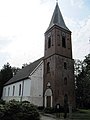 Church in c. 2011
 Modern castle
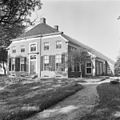 Farm (1969)


References
- (in Dutch) Kerncijfers wijken en buurten 2017, Statistics Netherlands, 2017. Retrieved on 2 December 2017.
- "Kerncijfers wijken en buurten 2021". Central Bureau Statistics. Retrieved 27 February 2022.
- (in Dutch) Resultaten voor "Vriescheloo,", Postcode.nl. Retrieved on 27 April 2014.
- "Vriescheloo". Plaatsengids (in Dutch). Retrieved 27 February 2022.
- Redmer Alma (1998). Vriescheloo. Zwolle: Waanders Uitgevers. p. 219. ISBN 90 400 9258 3.
- "De Korenbloem". Molen Database (in Dutch). Retrieved 27 February 2022.
External links
 Media related to Vriescheloo at Wikimedia Commons
Neighbouring villages | ||||||||||||||||
|---|---|---|---|---|---|---|---|---|---|---|---|---|---|---|---|---|
| ||||||||||||||||
This Groningen location article is a stub. You can help Wikipedia by expanding it. |
Текст в блоке "Читать" взят с сайта "Википедия" и доступен по лицензии Creative Commons Attribution-ShareAlike; в отдельных случаях могут действовать дополнительные условия.
Другой контент может иметь иную лицензию. Перед использованием материалов сайта WikiSort.org внимательно изучите правила лицензирования конкретных элементов наполнения сайта.
Другой контент может иметь иную лицензию. Перед использованием материалов сайта WikiSort.org внимательно изучите правила лицензирования конкретных элементов наполнения сайта.
2019-2026
WikiSort.org - проект по пересортировке и дополнению контента Википедии
WikiSort.org - проект по пересортировке и дополнению контента Википедии