world.wikisort.org - Netherlands
Harpel is a hamlet in the Dutch province of Groningen. It is a part of the municipality of Westerwolde, and lies about 28 km north of Emmen.
Harpel | |
|---|---|
Hamlet | |
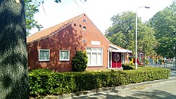
 Community house | |
| Coordinates: 52°59′59″N 7°5′18″E | |
| Country | Netherlands |
| Province | Groningen |
| Municipality | Westerwolde |
| Area | |
| • Total | 1.91 km2 (0.74 sq mi) |
| Elevation | 3.4 m (11.2 ft) |
| Population (2021)[1] | |
| • Total | 155 |
| • Density | 81/km2 (210/sq mi) |
| Postal code | 9541[1] |
| Dialing code | 0599 |
The hamlet was first mentioned in 1867 as Harpel. The etymology in unclear.[3] The postal authorities have placed it under Vlagtwedde.[4] Harpel has place name signs.[5]
References
- "Kerncijfers wijken en buurten 2021". Central Bureau of Statistics. Retrieved 9 April 2022.
- "Postcodetool for 9541AA". Actueel Hoogtebestand Nederland (in Dutch). Het Waterschapshuis. Retrieved 8 April 2022.
- "Harpel - (geografische naam)". Etymologiebank (in Dutch). Retrieved 9 April 2022.
- "Postcode 9541 in Vlagtwedde". Postcode bij adres (in Dutch). Retrieved 9 April 2022.
- "Harpel". Plaatsengids (in Dutch). Retrieved 9 April 2022.
External links
 Media related to Harpel at Wikimedia Commons
Текст в блоке "Читать" взят с сайта "Википедия" и доступен по лицензии Creative Commons Attribution-ShareAlike; в отдельных случаях могут действовать дополнительные условия.
Другой контент может иметь иную лицензию. Перед использованием материалов сайта WikiSort.org внимательно изучите правила лицензирования конкретных элементов наполнения сайта.
Другой контент может иметь иную лицензию. Перед использованием материалов сайта WikiSort.org внимательно изучите правила лицензирования конкретных элементов наполнения сайта.
2019-2025
WikiSort.org - проект по пересортировке и дополнению контента Википедии
WikiSort.org - проект по пересортировке и дополнению контента Википедии

