world.wikisort.org - Netherlands
Serooskerke is a village in the Dutch province of Zeeland. It is a part of the municipality of Veere, and lies about 6 km north of Middelburg.
Serooskerke | |
|---|---|
Village | |
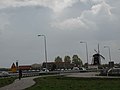
 Windmill De Jonge Johannes, Serooskerke | |
 Coat of arms | |
 Serooskerke Location in the province of Zeeland in the Netherlands  Serooskerke Serooskerke (Netherlands) | |
| Coordinates: 51°32′55″N 3°35′43″E | |
| Country | Netherlands |
| Province | Zeeland |
| Municipality | Veere |
| Area | |
| • Total | 9.03 km2 (3.49 sq mi) |
| Elevation | 1.3 m (4.3 ft) |
| Population (2021)[1] | |
| • Total | 1,825 |
| • Density | 200/km2 (520/sq mi) |
| Time zone | UTC+1 (CET) |
| • Summer (DST) | UTC+2 (CEST) |
| Postal code | 4356[1] |
| Dialing code | 0118 |
History
The village was first mentioned before 1207 as Alerdeskirkam, and means "(private) church of Alard (person)".[3] Serooskerke is a circular church village which developed in the 12th century on a ridge. Monastery Mariëndaal was built south of the village in the 13th century. It was destroyed in 1574.[4]
The Dutch Reformed church is a single aisled church with a wide tower. The tower dates from the 15th century. The church was destroyed between 1572 and 1574 and later rebuilt.[4]
Serooskerke was home to 892 people in 1840.[5] It was a separate municipality until 1966, when it was merged with Veere.[6]
In 1966, a farm worker was digging the field near the fire station and discovered a golden coin. Almost 1,100 golden coins from the late 16th and early 17th century were discovered. The municipality was entitled to half the proceeds and built a swimming pool from the money.[5]
Gallery
 View on Serooskerke
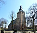 Johanneskerk


References
- "Kerncijfers wijken en buurten 2021". Central Bureau of Statistics. Retrieved 23 April 2022.
- "Postcodetool for 4353AA". Actueel Hoogtebestand Nederland (in Dutch). Het Waterschapshuis. Retrieved 23 April 2022.
- "Serooskerke - (geografische naam)". Etymologiebank (in Dutch). Retrieved 23 April 2022.
- Piet van Cruyningen & Ronald Stenvert (2003). Serooskerke (gemeente Veere) (in Dutch). Zwolle: Waanders. ISBN 90 400 8830 6. Retrieved 23 April 2022.
- "Serooskerke (Walcheren)". Plaatsengids (in Dutch). Retrieved 23 April 2022.
- Ad van der Meer and Onno Boonstra, Repertorium van Nederlandse gemeenten, KNAW, 2011.
External links
 Media related to Serooskerke (Walcheren) at Wikimedia Commons
This article about a location in Zeeland is a stub. You can help Wikipedia by expanding it. |
На других языках
[de] Serooskerke (Walcheren)
Serooskerke (seeländisch Stroskerke oder Seros) ist ein Dorf in der niederländischen Provinz Zeeland auf der Halbinsel Walcheren. Es gehört zur Gemeinde Veere und hat 1.805 Einwohner (Stand 1. Januar 2020).[1] Es ist ein für Walcheren typisches Dorf: ein kleiner Ortskern, bestehend aus Kirche mit Kirchplatz, um den sich einige Betriebe und Wohnhäuser gruppieren. Unmittelbar östlich des Dorfes läuft die N57 vom nordöstlich gelegenen Oosterschelde-Sturmflutwehr in Richtung Middelburg. Nördlich des Dorfes führt die N287 nach Oostkapelle.[2]- [en] Serooskerke, Walcheren
Другой контент может иметь иную лицензию. Перед использованием материалов сайта WikiSort.org внимательно изучите правила лицензирования конкретных элементов наполнения сайта.
WikiSort.org - проект по пересортировке и дополнению контента Википедии