world.wikisort.org - Netherlands
Aagtekerke (Dutch pronunciation: [ˈaːxtəˌkɛrkə]) is a village in the Dutch province of Zeeland. It is a part of the municipality of Veere, and lies about 9 km (6 mi) northwest of Middelburg.[3]
Aagtekerke | |
|---|---|
 | |
 Seal | |
 | |
 | |
 Aagtekerke Location in the Netherlands  Aagtekerke Aagtekerke (Netherlands) Aagtekerke Aagtekerke (Europe) | |
| Coordinates: 51°33′N 3°31′E | |
| Country | |
| Province | Zeeland |
| Municipality | Veere |
| Area | |
| • Total | 9.91 km2 (3.83 sq mi) |
| Elevation | 1.0 m (3.3 ft) |
| Population (2021)[1] | |
| • Total | 1,480 |
| • Density | 150/km2 (390/sq mi) |
| Time zone | UTC+1 (CET) |
| • Summer (DST) | UTC+2 (CEST) |
| Postal code | 4363[1] |
| Dialing code | 0118 |
History
The village was first mentioned in 1327 as "in atrio Sanctae Agathae", and means church dedicated to Agatha of Sicily. The St Agatha Church in Domburg was disassembled around 1320 and moved to the Aagtekerke.[4] Aagetekerke is a circular village around the church.[5]
The Dutch Reformed church the successor of the medieval church. The tower was built in the 15th century, and the nave received its current shape in 1625.[5] At the end of the 13th century, a Cistercian nunnery was established in Aagtekerke. It was destroyed somewhere between 1572 and 1574 during the Dutch Revolt.[6]
Aagtekerke was home to 380 people in 1840.[6] Until 1 July 1966, Aagtekerke was a separate municipality. On that date, it was merged into the municipality of Mariekerke.[7]
Aagtekerke is a conservative Protestant village, located in the Dutch Bible Belt. In the 2010 municipal elections, 62 percent of the local population voted for the Reformed Political Party (SGP). The three Christian parties in the elections (the Reformed Political Party, the ChristianUnion and the Christian Democratic Appeal) gained a combined total of almost 70 percent of the votes.
Gallery
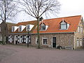 Houses on the village square
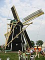 Aagtekerkse mill


References
- "Kerncijfers wijken en buurten 2021". Central Bureau of Statistics. Retrieved 22 April 2022.
- "Postcodetool for 4363AA". Actueel Hoogtebestand Nederland (in Dutch). Het Waterschapshuis. Retrieved 22 April 2022.
- "Aagtekerke Map — Satellite Images of Aagtekerke on Maplandia".
- "Aagtekerke - (geografische naam)". Etymologiebank (in Dutch). Retrieved 22 April 2022.
- Piet van Cruyningen & Ronald Stenvert (2003). Aagetekerke (in Dutch). Zwolle: Waanders. ISBN 90 400 8830 6. Retrieved 22 April 2022.
- "Aagtekerke". Plaatsengids (in Dutch). Retrieved 22 April 2022.
- Ad van der Meer and Onno Boonstra, Repertorium van Nederlandse gemeenten, KNAW, 2011.
Authority control | |
|---|---|
| General |
|
| National libraries | |
На других языках
[de] Aagtekerke
Aagtekerke (seeländisch Aegte) ist ein Dorf der Gemeinde Veere in Zeeland. Am 1. Januar 2020 hatte der Ort 1505 Einwohner.[1] Aagtekerke liegt drei Kilometer von Domburg, sechs Kilometer von Westkapelle und vier Kilometer von Oostkapelle entfernt.- [en] Aagtekerke
Другой контент может иметь иную лицензию. Перед использованием материалов сайта WikiSort.org внимательно изучите правила лицензирования конкретных элементов наполнения сайта.
WikiSort.org - проект по пересортировке и дополнению контента Википедии