world.wikisort.org - Netherlands
Loerbeek is a village in the eastern Netherlands, near the German border. It's close to Beek and Nieuw-Dijk. There's a big forest called Bergherbos, where people can walk, mountain-bike and ride horse.
Loerbeek | |
|---|---|
Village | |
 Farm in Loerbeek | |
 Loerbeek Location in the Netherlands  Loerbeek Loerbeek (Netherlands) | |
| Coordinates: 51°55′16″N 6°11′41″E | |
| Country | Netherlands |
| Province | Gelderland |
| Municipality | Montferland |
| Area | |
| • Total | 4.25 km2 (1.64 sq mi) |
| Elevation | 18 m (59 ft) |
| Population (2021)[1] | |
| • Total | 695 |
| • Density | 160/km2 (420/sq mi) |
| Time zone | UTC+1 (CET) |
| • Summer (DST) | UTC+2 (CEST) |
| Postal code | 7036 & 7037[1] |
| Dialing code | 0316 |
It was first mentioned in 1240 as Loberke. The etymology is unknown.[3]
Gallery
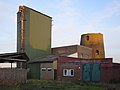 Remains of the former windmill (1845)
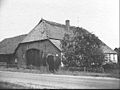 Farm in Loerbeek


References
- "Kerncijfers wijken en buurten 2021". Central Bureau of Statistics. Retrieved 23 March 2022.
- "Postcodetool for 7037AA". Actueel Hoogtebestand Nederland (in Dutch). Het Waterschapshuis. Retrieved 23 March 2022.
- "Loerbeek - (geografische naam)". Etymologiebank (in Dutch). Retrieved 23 March 2022.
Wikimedia Commons has media related to Loerbeek.
This Gelderland location article is a stub. You can help Wikipedia by expanding it. |
Текст в блоке "Читать" взят с сайта "Википедия" и доступен по лицензии Creative Commons Attribution-ShareAlike; в отдельных случаях могут действовать дополнительные условия.
Другой контент может иметь иную лицензию. Перед использованием материалов сайта WikiSort.org внимательно изучите правила лицензирования конкретных элементов наполнения сайта.
Другой контент может иметь иную лицензию. Перед использованием материалов сайта WikiSort.org внимательно изучите правила лицензирования конкретных элементов наполнения сайта.
2019-2026
WikiSort.org - проект по пересортировке и дополнению контента Википедии
WikiSort.org - проект по пересортировке и дополнению контента Википедии