world.wikisort.org - Netherlands
Loil (Dutch pronunciation: [loːl]) is a village in the Dutch province of Gelderland. It is a part of the municipality of Montferland. Loil forms a single urban area with Didam and is often referred to as a neighbourhood,[3] but it is an independent village.[4]
Loil | |
|---|---|
Village | |
 Wind mill De Korenbloem | |
 Flag  Coat of arms | |
 Loil Location in the Netherlands  Loil Loil (Netherlands) | |
| Coordinates: 51.95158°N 6.14043°E | |
| Country | Netherlands |
| Province | Gelderland |
| Municipality | Montferland |
| Area | |
| • Total | 8.19 km2 (3.16 sq mi) |
| Elevation | 12 m (39 ft) |
| Population (2021)[1] | |
| • Total | 1,560 |
| • Density | 190/km2 (490/sq mi) |
| Time zone | UTC+1 (CET) |
| • Summer (DST) | UTC+2 (CEST) |
| Postal code | 6941[1] |
| Dialing code | 0316 |
History
It was first mentioned around 1200 as Loel, and means "little open forest".[5] Even though it is spelt Loil, it should be pronounced as Lool.[4] ’t Hof Loil was a manor house which was first mentioned in 1390; however, the building was older than the castle. The manor house was destroyed in a fire in 2014. The village of Loil developed around the manor house.[6] Loil Castle was built around 1300 and belonged to the Duchy of Cleves. In 1457, the castle and the heerlijkheid were sold to the Lord of Bergh. In 1711, it was transferred to the Dros of Didam. The castle was demolished around 1920.[6] In 1840, Loil was home to 680 people.[4]
The grist mill De Korenbloem was built in 1855. It was restored in 1970 and 1988–1989.[7] The Roman Catholic church opened in 1910 and is a church without a tower.[8] Loil has become a single urban area with Didam, and the postal authorities have placed it under Didam,[3] but it has not been annexed.[4]
Gallery
 Sunrise in Loil
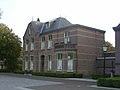 House in Loil
 Church in Loil


References
- "Kerncijfers wijken en buurten 2021". Central Bureau of Statistics. Retrieved 23 March 2022.
- "Postcodetool for 6941AA". Actueel Hoogtebestand Nederland (in Dutch). Het Waterschapshuis. Retrieved 23 March 2022.
- "Postcode Loil in Montferland". Postcode bij adres (in Dutch). Retrieved 23 March 2022.
- "Loil". Plaatsengids (in Dutch). Retrieved 23 March 2022.
- "Loil - (geografische naam)". Etymologiebank (in Dutch). Retrieved 23 March 2022.
- "Huis Loil". Loil (in Dutch). Retrieved 23 March 2022.
- "De Korenbloem". Molen database (in Dutch). Retrieved 23 March 2022.
- Ronald Stenvert & Sabine Broekhoven (2000). "Didam" (in Dutch). Zwolle: Waanders. p. 137. ISBN 90 400 9406 3. Retrieved 23 March 2022.
External links
 Media related to Loil at Wikimedia Commons
- Official website (in Dutch)
Другой контент может иметь иную лицензию. Перед использованием материалов сайта WikiSort.org внимательно изучите правила лицензирования конкретных элементов наполнения сайта.
WikiSort.org - проект по пересортировке и дополнению контента Википедии