world.wikisort.org - Netherlands
Lhee is a hamlet in the Dutch province of Drenthe. It is a part of the municipality of Westerveld, and lies about 13 kilometres (8.1 mi) north of Hoogeveen.
Lhee | |
|---|---|
Hamlet | |
 Farm in Lhee | |
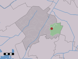 The village (dark red) and the statistical district (light green) of Lhee in the municipality of Westerveld. | |
 Lhee Location in the Netherlands  Lhee Lhee (Netherlands) | |
| Coordinates: 52°49′42″N 6°23′37″E | |
| Country | Netherlands |
| Province | Drenthe |
| Municipality | Westerveld |
| Area | |
| • Total | 29.99 km2 (11.58 sq mi) |
| Elevation | 10 m (30 ft) |
| Population (2021)[1] | |
| • Total | 385 |
| • Density | 13/km2 (33/sq mi) |
| Time zone | UTC+1 (CET) |
| • Summer (DST) | UTC+2 (CEST) |
| Postal code | 7991[1] |
| Dialing code | 0521 |
The hamlet was first mentioned in 1181 as "In Lede". The etymology is unclear.[3]
Around 1800, a little school was built in Lhee. In 1953, it was moved brick by brick to the Netherlands Open Air Museum despite protests from the former teacher.[4] Lhee was home to 229 people in 1840.[4]
References
- "Kerncijfers wijken en buurten 2021". Central Bureau of Statistics. Retrieved 12 April 2022.
two entries
- "Postcodetool for 7991AA". Actueel Hoogtebestand Nederland (in Dutch). Het Waterschapshuis. Retrieved 12 April 2022.
- "Lhee - (geografische naam)". Etymologiebank (in Dutch). Retrieved 12 April 2022.
- "Lhee". Plaatsengids (in Dutch). Retrieved 12 April 2022.
| Wikimedia Commons has media related to Lhee. |
This Drenthe location article is a stub. You can help Wikipedia by expanding it. |
Текст в блоке "Читать" взят с сайта "Википедия" и доступен по лицензии Creative Commons Attribution-ShareAlike; в отдельных случаях могут действовать дополнительные условия.
Другой контент может иметь иную лицензию. Перед использованием материалов сайта WikiSort.org внимательно изучите правила лицензирования конкретных элементов наполнения сайта.
Другой контент может иметь иную лицензию. Перед использованием материалов сайта WikiSort.org внимательно изучите правила лицензирования конкретных элементов наполнения сайта.
2019-2026
WikiSort.org - проект по пересортировке и дополнению контента Википедии
WikiSort.org - проект по пересортировке и дополнению контента Википедии