world.wikisort.org - Netherlands
Leerbroek is a village in the Dutch province of Utrecht. It is a part of the municipality of Vijfheerenlanden, and lies about 9 km (6 mi) northeast of Gorinchem.
Leerbroek | |
|---|---|
Village | |
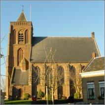 Church of Leerbroek | |
 Leerbroek Location in the Netherlands  Leerbroek Leerbroek (Netherlands) | |
| Coordinates: 51.9071°N 5.0497°E | |
| Country | Netherlands |
| Province | Utrecht |
| Municipality | Vijfheerenlanden |
| Area | |
| • Total | 3.59 km2 (1.39 sq mi) |
| Elevation | −0.1 m (−0.3 ft) |
| Population (2021)[1] | |
| • Total | 1,085 |
| • Density | 300/km2 (780/sq mi) |
| Time zone | UTC+1 (CET) |
| • Summer (DST) | UTC+2 (CEST) |
| Postal code | 4245[1] |
| Dialing code | 0345 |
Leerbroek was a separate municipality between 1817, when it was separated from Meerkerk, and 1986, when it merged with Zederik in the province of South Holland.[3] When Zederik merged into the new municipality Vijfheerenlanden in 2019, it became a part of the province of Utrecht.[4]
History
The village was first mentioned between 1395 and 1396 as Lederbroec, and means "canal through swampy land".[5] Leerbroek started as a cultivation project in the 12th century. The Dutch Reformed Church dated from the 16th century, but burnt down in 1935. It was rebuilt in 1936.[6] In 1840, it was home to 214 people.[7]
Gallery
 Map of the former municipality in 1866
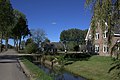 Farms in Leerbroek
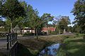 More farms
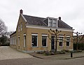 House in Leerbroek


References
- "Kerncijfers wijken en buurten 2021". Central Bureau of Statistics. Retrieved 26 March 2022.
two entries
- "Postcodetool for 4245JS". Actueel Hoogtebestand Nederland (in Dutch). Het Waterschapshuis. Retrieved 26 March 2022.
- Ad van der Meer and Onno Boonstra, "Repertorium van Nederlandse gemeenten", KNAW, 2006. "KNAW > Publicaties > Detailpagina". Archived from the original on 2007-02-20. Retrieved 2009-12-03.
- "Fusiegemeente Vijfheerenlanden in provincie Utrecht". AD.nl. Retrieved 12 January 2019.
- "Leerbroek - (geografische naam)". Etymologiebank (in Dutch). Retrieved 26 March 2022.
- Ronald Stenvert & Chris Kolman (1996). Leerbroek (in Dutch). Zwolle: Waanders. ISBN 90-400-9757-7. Retrieved 26 March 2022.
- "Leerbroek". Plaatsengids (in Dutch). Retrieved 26 March 2022.
This Utrecht location article is a stub. You can help Wikipedia by expanding it. |
На других языках
[de] Leerbroek
Leerbroek ist ein Ort in der Gemeinde Vijfheerenlanden in der Provinz Utrecht, Niederlande. Am 1. Januar 2020 zählte der Ort 1.635 Einwohner.[1]- [en] Leerbroek
Другой контент может иметь иную лицензию. Перед использованием материалов сайта WikiSort.org внимательно изучите правила лицензирования конкретных элементов наполнения сайта.
WikiSort.org - проект по пересортировке и дополнению контента Википедии