world.wikisort.org - Netherlands
Kruiningen is a village in the Dutch province of Zeeland. It is located in the municipality of Reimerswaal, about 5 km south of the village of Yerseke.[3]
Kruiningen | |
|---|---|
Village | |
 Tower of the Johanneskerk of Kruiningen | |
 Flag  Coat of arms | |
 Kruiningen Location in the province of Zeeland in the Netherlands  Kruiningen Kruiningen (Netherlands) | |
| Coordinates: 51°26′53″N 4°2′3″E | |
| Country | Netherlands |
| Province | Zeeland |
| Municipality | Reimerswaal |
| Area | |
| • Total | 14.08 km2 (5.44 sq mi) |
| Elevation | 0.2 m (0.7 ft) |
| Population (2021)[1] | |
| • Total | 4,750 |
| • Density | 340/km2 (870/sq mi) |
| Time zone | UTC+1 (CET) |
| • Summer (DST) | UTC+2 (CEST) |
| Postal code | 4416[1] |
| Dialing code | 0113 |
Kruiningen has a station on the railway line Bergen op Zoom - Vlissingen. Kruiningen achieved some notoriety as departure and arrival of the ferry Kruiningen-Perkpolder. In 2003, this ferry closed in connection with the opening of the Westerscheldetunnel.
History
The place where Kruiningen was built, was one of the islands that later formed Zuid-Beveland. The area was diked by monks of the abbeys of Ten Duinen and Ter Doest. Kruiningen was hit hard during the Flood of 1953, 62 people died and the entire village came for six months under the influence of the tides. The Johanneskerk was rebuilt in the 15th and 16th century after a fire in the 14th century. In the church is the tomb of Arnoud van Cruningen (deceased in 1561), a gentleman from the Van Kruiningen family. The octagonal mill De Oude Molen was built in 1801.
Notable people
- Alfred Colpaert (born 1957), university professor in physical geography
Gallery
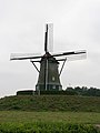 Wind mill De Oude Molen
 House in Kruiningen
 Town hall
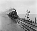 Train after the North Sea flood of 1953


References
- "Kerncijfers wijken en buurten 2021". Central Bureau of Statistics. Retrieved 20 April 2022.
- "Postcodetool for 4416AA". Actueel Hoogtebestand Nederland (in Dutch). Het Waterschapshuis. Retrieved 20 April 2022.
- ANWB Topografische Atlas Nederland, Topografische Dienst and ANWB, 2005.
| Authority control |
|
|---|
This article about a location in Zeeland is a stub. You can help Wikipedia by expanding it. |
На других языках
[de] Kruiningen
Kruiningen (seeländisch Krunege) ist ein Dorf auf Zuid-Beveland in der niederländischen Provinz Zeeland und liegt rund fünf Kilometer südlich von Yerseke. Kruiningen war bis 1970 eine selbständige Gemeinde, zu der auch Hansweert gehörte; heute zählt es zu der Gemeinde Reimerswaal. Im Januar 2020 zählte das Dorf 4.665 Einwohner.[1]- [en] Kruiningen
Другой контент может иметь иную лицензию. Перед использованием материалов сайта WikiSort.org внимательно изучите правила лицензирования конкретных элементов наполнения сайта.
WikiSort.org - проект по пересортировке и дополнению контента Википедии