world.wikisort.org - Netherlands
Harmelerwaard is a hamlet in the Dutch province of Utrecht. It is a part of the municipality of Woerden, and lies about 9 km west of Utrecht.
Harmelerwaard | |
|---|---|
Hamlet | |
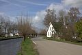
 Draw bridge in Harmerlerwaard | |
 Harmelerwaard Location in the Netherlands  Harmelerwaard Harmelerwaard (Netherlands) | |
| Coordinates: 52°05′19″N 4°58′55″E | |
| Country | Netherlands |
| Province | Utrecht |
| Municipality | Woerden |
| Time zone | UTC+1 (CET) |
| • Summer (DST) | UTC+2 (CEST) |
| Postal code | 3481[1] |
| Dialing code | 0348[1] |
The hamlet was first mentioned between 1280 and 1287 as Hermaelrewart, and means "land near water belonging to Harmelen".[2] It is not a statistical entity,[3] and the postal authorities have placed it under Harmelen.[1] It has no place name signs. In 1840, Harmelerwaard was home to 40 people. Nowadays, it consists of about 80 houses.[4]
Gallery
 Street view
 Street view


References
- "Postcode Harmelerwaard in Harmelen". Postcode bij adres (in Dutch). Retrieved 26 March 2022.
- "Harmelerwaard - (geografische naam)". Etymologiebank (in Dutch). Retrieved 24 March 2022.
- "Kerncijfers wijken en buurten 2021". Central Bureau of Statistics. Retrieved 26 March 2022.
not found
- "Harmerlerwaard". Plaatsengids (in Dutch). Retrieved 26 March 2022.
This Utrecht location article is a stub. You can help Wikipedia by expanding it. |
Текст в блоке "Читать" взят с сайта "Википедия" и доступен по лицензии Creative Commons Attribution-ShareAlike; в отдельных случаях могут действовать дополнительные условия.
Другой контент может иметь иную лицензию. Перед использованием материалов сайта WikiSort.org внимательно изучите правила лицензирования конкретных элементов наполнения сайта.
Другой контент может иметь иную лицензию. Перед использованием материалов сайта WikiSort.org внимательно изучите правила лицензирования конкретных элементов наполнения сайта.
2019-2026
WikiSort.org - проект по пересортировке и дополнению контента Википедии
WikiSort.org - проект по пересортировке и дополнению контента Википедии