world.wikisort.org - Netherlands
Erica (also Nieuw-Slagharen[3]) is a town in the north-eastern Netherlands. It is located in Emmen, Drenthe.[4] It started as a peat and buckwheat colony.
Erica | |
|---|---|
Town | |
 | |
 Erica Location in province of Drenthe in the Netherlands  Erica Erica (Netherlands) | |
| Coordinates: 52.71532°N 6.92596°E | |
| Country | Netherlands |
| Province | Drenthe |
| Municipality | Emmen |
| Established | 1863 |
| Area | |
| • Total | 24.53 km2 (9.47 sq mi) |
| Elevation | 16 m (52 ft) |
| Population (2021)[1] | |
| • Total | 4,740 |
| • Density | 190/km2 (500/sq mi) |
| Time zone | UTC+1 (CET) |
| • Summer (DST) | UTC+2 (CEST) |
| Postal code | 7887[1] |
| Dialing code | 0591 |
History
Erica was established in 1863.[3] The first inhabitant came from Slagharen.[5]: 67 A fuel shortage prompted large-scale efforts to drain the peat in the area and cut them for fuel. People were drawn to the area and canals were dug, both to drain the peat and to transport the cuts. Buckwheat was farmed on the drained peats.[3] It was originally called Nieuw-Slagharen, but has been renamed Erica after the heath plant.[6]
Erica started as a linear settlement. In 1867, the Hoogeveense Vaart was dug, and a second settlement was constructed. Later, the two were merged.[3] Many of the early inhabitants of Erica came from neighbouring Germany and were Roman Catholic, and in 1866, a Catholic church was built. The current church dates from 1933.[7][8] In 1932, Erica was home to 2,663 people.[5]: 89
In 1897, the windmill De Heidebloem was constructed. It was restored in 1978, and is still in use to grind grain.[3][7] In the 1960s, greenhouse cultivation started in Erica.[9] Erica can reached via the A37 motorway.[10]
Gallery
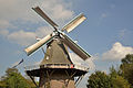 Mill De Heidebloem
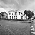 Jugendstil house in Erica
 Church
 Sod house near the canal (1997)


References
- "Kerncijfers wijken en buurten 2021". Central Bureau of Statistics. Retrieved 10 March 2022.
Two listings
- "Postcodetool for 7887AA". Actueel Hoogtebestand Nederland (in Dutch). Het Waterschapshuis. Retrieved 10 March 2022.
- Ronald Stenvert (2001). Erica (in Dutch). Zwolle: Waanders. p. 119. ISBN 90 400 9454 3. Retrieved 9 March 2022.
- Stratenatlas van Nederland: alle straten, lanen, pleinen, steegjes en wegen. Spectrum. 1984. ISBN 978-90-274-8313-3.
- Jan Harm Tuntler (1935). In en om de gemeente Emmen (in Dutch). Ten Kate.
- "Erica - (geografische naam)". Etymologiebank (in Dutch). Retrieved 10 March 2022.
- "Erica". Plaatsengids (in Dutch). Retrieved 10 March 2022.
- "Erica". Serc (in Dutch). Retrieved 10 March 2022.
- "Glastuinbouw in Erica". Tuinbouw Emmen (in Dutch). Retrieved 10 March 2022.
- "Raad Emmen: 'Laatste woord over zonnewand A37 nog niet gezegd'". RTV Drenthe (in Dutch). 7 June 2021. Retrieved 10 March 2022.
Другой контент может иметь иную лицензию. Перед использованием материалов сайта WikiSort.org внимательно изучите правила лицензирования конкретных элементов наполнения сайта.
WikiSort.org - проект по пересортировке и дополнению контента Википедии