world.wikisort.org - Netherlands
Klazienaveen is a town to the southeast of Emmen in the Dutch province of Drenthe. It is located approx 5 km (3.1 mi) from the German border. Klazienaveen started as a peat colony owned by Willem Albert Scholten. It has been named after Klaassien Sluis, the wife of Scholten.
Klazienaveen | |
|---|---|
 Klazienaveen (Molenwijk) | |
 Klazienaveen Location in province of Drenthe in the Netherlands  Klazienaveen Klazienaveen (Netherlands) | |
| Coordinates: 52°44′N 6°59′E | |
| Country | Netherlands |
| Province | Drenthe |
| Municipality | Emmen |
| Established | 1899 |
| Area | |
| • Total | 30.05 km2 (11.60 sq mi) |
| Elevation | 21 m (69 ft) |
| Population (2021)[1] | |
| • Total | 11,980 |
| • Density | 400/km2 (1,000/sq mi) |
| Postal code | 7891 |
| Dialing code | 0591 |
| Major roads | A37 |
History
In 1874, Willem Albert Scholten bought the 974 hectares (2,410 acres) Smeulveen to exploit the peat.[3] In 1890, Scholten offered the skipper Jan Adde Hazewinkel a flag as the first person to transport the peat.[4] In 1899, a village appeared along the canal. In 1903, Scholten's son Jan Evert renamed Smeulveen and the village Klazienaveen after his mother Klaassien Sluis.[5] It is one of the two villages in the Netherlands named after a non-royal woman.[4] In 1932, it was home to 2,327 people.[6]
In 1921, the Purit factory opened and produces Norit (activated carbon).[5] On 23 March 1945, the factory was bombed by the Royal Air Force causing eight deaths among the factory workers. The clock in the engine room stopped and has remained as a reminder.[4] Since 2012, it is owned by Cabot Corporation.[7] After World War II, Klazienaveen started expanding rapidly.[5] In the 1960s, greenhouse cultivation started in Klazienaveen.[8] The town can reached via the A37 motorway.[9]
Notable people
- Ruben Roosken (born 2000), footballer[10]
- Hanja Maij-Weggen (born 1943), politician and former Queen's Commissioner of North Brabant[11]
Gallery
 Church in Klazienaveen
 Peat worker by Bert Kiewit
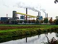 Norit factory
 Shopping mall


References
- "Kerncijfers wijken en buurten 2021". Central Bureau of Statistics. Retrieved 5 March 2022.
- "Postcodetool for 7891AA". Actueel Hoogtebestand Nederland (in Dutch). Het Waterschapshuis. Retrieved 5 March 2022.
- "Willem Albert Scholten". Geheugen van Drenthe (in Dutch). Retrieved 5 March 2022.
- "Klazienaveen". Plaatsengids (in Dutch). Retrieved 5 March 2022.
- Ronald Stenvert (2001). Klazienaveen (in Dutch). Zwolle: Waanders Uitgevers. p. 140. ISBN 90 400 9454 3. Retrieved 5 March 2022.
- Jan Harm Tuntler (1935). In en om de gemeente Emmen (in Dutch). Ten Kate. p. 89.
- Resnick-Ault, Jessica (21 June 2012). "Cabot Corp. to Buy Norit for $1.1 Billion, Add Activated Carbon". Bloomberg.
- "Glastuinbouw in Klazienaveen". Tuinbouw Emmen (in Dutch). Retrieved 10 March 2022.
- "Halfjaar lang wegwerkzaamheden aan A37 Holsloot richting Duitse grens". Klazienaveen Lokaal (in Dutch). Retrieved 10 March 2022.
- "Ruben Roosken: Klazienavener bij FC Emmen én verre familie van goalgetter Tonny Roosken". Dagblad van het Noorden (in Dutch). 16 September 2019. Retrieved 5 March 2022.
- "J.R.H. (Hanja) Maij-Weggen". Dutch Parliament (in Dutch). Retrieved 5 March 2022.
External links
 Media related to Klazienaveen at Wikimedia Commons
- Local news site (in Dutch)
| Authority control |
|
|---|
Другой контент может иметь иную лицензию. Перед использованием материалов сайта WikiSort.org внимательно изучите правила лицензирования конкретных элементов наполнения сайта.
WikiSort.org - проект по пересортировке и дополнению контента Википедии