world.wikisort.org - Netherlands
De Waal is a village in the Dutch province of North Holland. It is a part of the municipality of Texel, and lies about 15 km north of Den Helder.
De Waal | |
|---|---|
Village | |
 Street view | |
 De Waal Location in the Netherlands  De Waal Location in the province of North Holland in the Netherlands | |
| Coordinates: 53°4′N 4°49′E | |
| Country | Netherlands |
| Province | North Holland |
| Municipality | Texel |
| Area | |
| • Total | 0.35 km2 (0.14 sq mi) |
| Elevation | 0.6 m (2.0 ft) |
| Population (2021)[1] | |
| • Total | 210 |
| • Density | 600/km2 (1,600/sq mi) |
| Time zone | UTC+1 (CET) |
| • Summer (DST) | UTC+2 (CEST) |
| Postal code | 1793[1] |
| Dialing code | 0222 |
The village was first mentioned in 1295 as "sancti Bonifacii in Waelkerken", and means "pond created after a dike breach".[3] De Waal started to developed after the Waalenburg polder was created in 1436. The Dutch Reformed church is built on a terp (artificial hill). It was destroyed in 1945 during the Georgian uprising. A new church was built in 1952 and a tower was added in 1961.[4]
Gallery
 Sculpture 'the Game' designed by Marijn Koenen Gorter
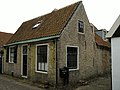 House in De Waal
 Dutch Reformed church
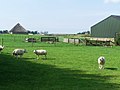 Farmland near De Waal


References
- "Kerncijfers wijken en buurten 2021". Central Bureau of Statistics. Retrieved 2 May 2022.
- "Postcodetool for 1793AA". Actueel Hoogtebestand Nederland (in Dutch). Het Waterschapshuis. Retrieved 2 May 2022.
- "De Waal - (geografische naam)". Etymologiebank (in Dutch). Retrieved 2 May 2022.
- "De Waal". Plaatsengids (in Dutch). Retrieved 2 May 2022.
Wikimedia Commons has media related to De Waal.
This North Holland location article is a stub. You can help Wikipedia by expanding it. |
На других языках
[de] De Waal (Texel)
Vorlage:Infobox Ort in den Niederlanden/Wartung/Rahmen unnötig- [en] De Waal
Текст в блоке "Читать" взят с сайта "Википедия" и доступен по лицензии Creative Commons Attribution-ShareAlike; в отдельных случаях могут действовать дополнительные условия.
Другой контент может иметь иную лицензию. Перед использованием материалов сайта WikiSort.org внимательно изучите правила лицензирования конкретных элементов наполнения сайта.
Другой контент может иметь иную лицензию. Перед использованием материалов сайта WikiSort.org внимательно изучите правила лицензирования конкретных элементов наполнения сайта.
2019-2025
WikiSort.org - проект по пересортировке и дополнению контента Википедии
WikiSort.org - проект по пересортировке и дополнению контента Википедии