world.wikisort.org - Netherlands
Oudeschild is a village in the Dutch province of North Holland. It is a part of the island municipality of Texel, and lies about 12 km northeast of Den Helder.
Oudeschild | |
|---|---|
Village | |
 Village of Oudeschild | |
 Oudeschild Location in the Netherlands  Oudeschild Location in the province of North Holland in the Netherlands | |
| Coordinates: 53°2′46″N 4°50′59″E | |
| Country | Netherlands |
| Province | North Holland |
| Municipality | Texel |
| Area | |
| • Total | 1.10 km2 (0.42 sq mi) |
| Elevation | 0.3 m (1.0 ft) |
| Population (2021)[1] | |
| • Total | 1,200 |
| • Density | 1,100/km2 (2,800/sq mi) |
| Time zone | UTC+1 (CET) |
| • Summer (DST) | UTC+2 (CEST) |
| Postal code | 1792[1] |
| Dialing code | 0222 |
Oudeschild is the fishing harbour of the island. It is situated at the Wadden Sea dyke. Next to the harbour, the windmill Traanroeier marks the site of the Maritime and Beachcombers Museum, which exhibits an interesting collection of objects found on the beaches of Texel.
In the 17th century, the Dutch East India Company ships sailing from Amsterdam waited for favourable winds at the Rede van Texel, on the sea near Oudeschild.
Close to the village is the Hoge Berg (the so-called "High Mountain"), a 15-metre-high (49 ft) hill. Near the Hoge Berg is the Russian cemetery. Here lie the Georgians who died in their uprising in 1945.
Gallery
 Aerial view of Oudeschild
 Harbour of Oudeschild
 Dutch Reformed Church
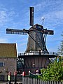 Windmill Traanroeier


References
- "Kerncijfers wijken en buurten 2021". Central Bureau of Statistics. Retrieved 2 May 2022.
- "Postcodetool for 1792AA". Actueel Hoogtebestand Nederland (in Dutch). Het Waterschapshuis. Retrieved 2 May 2022.
External links
![]() Media related to Oudeschild at Wikimedia Commons
Media related to Oudeschild at Wikimedia Commons
| Authority control |
|
|---|
This North Holland location article is a stub. You can help Wikipedia by expanding it. |
Другой контент может иметь иную лицензию. Перед использованием материалов сайта WikiSort.org внимательно изучите правила лицензирования конкретных элементов наполнения сайта.
WikiSort.org - проект по пересортировке и дополнению контента Википедии