 View of Puerto Angel's wharf
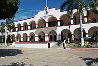 Municipal Palace, San Pedro Pochutla
 Municipal Palace, Santa María Tonameca
 Protected turtle eggs incubating in La Ventanilla
world.wikisort.org - Mexico
Pochutla District is located in the east of the Costa Region of the State of Oaxaca, Mexico. The primary city is San Pedro Pochutla.[1]
Pochutla District | |
|---|---|
District | |
 Oaxaca regions and districts: Costa in the southwest | |
 Pochutla District Pochutla District | |
| Coordinates: 15°44′N 96°28′W | |
| Country | |
| State | Oaxaca |
| Region | Costa |
| Area | |
| • Total | 3,773.29 km2 (1,456.88 sq mi) |
| Population (2010) | |
| • Total | 199,251 |
Municipalities

The district includes the following municipalities:[1]
Images of Pochutla District


References
- "Enciclopedia de los Municipios de México: Estado de Oaxaca". Retrieved 2010-07-08.
This article about a location in the Mexican state of Oaxaca is a stub. You can help Wikipedia by expanding it. |
Текст в блоке "Читать" взят с сайта "Википедия" и доступен по лицензии Creative Commons Attribution-ShareAlike; в отдельных случаях могут действовать дополнительные условия.
Другой контент может иметь иную лицензию. Перед использованием материалов сайта WikiSort.org внимательно изучите правила лицензирования конкретных элементов наполнения сайта.
Другой контент может иметь иную лицензию. Перед использованием материалов сайта WikiSort.org внимательно изучите правила лицензирования конкретных элементов наполнения сайта.
2019-2026
WikiSort.org - проект по пересортировке и дополнению контента Википедии
WikiSort.org - проект по пересортировке и дополнению контента Википедии