world.wikisort.org - Japan
Ōsaki (大崎市, Ōsaki-shi) is a city located in Miyagi Prefecture, Japan. As of 1 May 2020[update], the city had an estimated population of 128,763 in 51,567 households,[1] and a population density of 160 persons per km². The total area of the city is 796.76 square kilometres (307.63 sq mi). Ōsaki is a member of the World Health Organization’s Alliance for Healthy Cities (AFHC).[2]
Ōsaki
大崎市 | |
|---|---|
City | |
 upper:Furukawa festival, Kashima-dai middle:Kejonuma Leisure Land, Furukawa Station lower:Naruko Dam, Mount Kagoho | |
 Flag  Seal | |
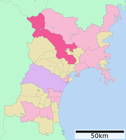 Location of Ōsaki in Miyagi Prefecture | |
 Ōsaki | |
| Coordinates: 38°34′37.6″N 140°57′20.1″E | |
| Country | Japan |
| Region | Tōhoku |
| Prefecture | Miyagi |
| First official recorded | 695 AD |
| Narugo Town Settled | April 20, 1921 |
| Furukawa City Settled | December 15, 1950 |
| As current city named | March 31, 2006 |
| Government | |
| • Mayor | Yasushi Ito |
| Area | |
| • Total | 796.76 km2 (307.63 sq mi) |
| Population (May 1, 2020) | |
| • Total | 128,763 |
| • Density | 160/km2 (420/sq mi) |
| Time zone | UTC+9 (Japan Standard Time) |
| Phone number | 0229-23-2111 |
| Address | 1-1 Furukawa Nanokamachi, Ōsaki-shi, Miyagi-ken 989-6188 |
| Climate | Cfa |
| Website | Official website |
| Symbols | |
| Flower | Flowering Dogwood |
| Tree | Rose |

Geography
Ōsaki is in north-central Miyagi Prefecture in the northern Sendai Plain. The Furukawa area in the center of the city is a base for commercial and service industries in the northern portion of Miyagi Prefecture, and the Naruko area in the northwestern of the city is noted for hot spring tourism . The Kashimadai and Matsuyama districts in the southeastern part of the city are within the commuting zone of Sendai.
Climate
Ōsaki has a humid subtropical climate (Köppen climate classification Cfa) characterized by hot summers and mild winters. The average annual temperature in Ōsaki is 11.5 °C. The average annual rainfall is 1249 mm with September as the wettest month. The temperatures are highest on average in August, at around 24.4 °C, and lowest in January, at around -0.6 °C.[3]
| Climate data for Kashimadai, Ōsaki (1991−2020 normals, extremes 1976−present) | |||||||||||||
|---|---|---|---|---|---|---|---|---|---|---|---|---|---|
| Month | Jan | Feb | Mar | Apr | May | Jun | Jul | Aug | Sep | Oct | Nov | Dec | Year |
| Record high °C (°F) | 15.3 (59.5) |
18.4 (65.1) |
22.7 (72.9) |
29.6 (85.3) |
31.3 (88.3) |
33.2 (91.8) |
35.5 (95.9) |
36.1 (97.0) |
34.2 (93.6) |
29.3 (84.7) |
23.5 (74.3) |
21.1 (70.0) |
36.1 (97.0) |
| Average high °C (°F) | 4.5 (40.1) |
5.5 (41.9) |
9.3 (48.7) |
15.1 (59.2) |
19.8 (67.6) |
22.9 (73.2) |
26.3 (79.3) |
27.9 (82.2) |
24.8 (76.6) |
19.5 (67.1) |
13.2 (55.8) |
7.2 (45.0) |
16.3 (61.4) |
| Daily mean °C (°F) | 0.3 (32.5) |
0.8 (33.4) |
3.9 (39.0) |
9.1 (48.4) |
14.7 (58.5) |
18.7 (65.7) |
22.2 (72.0) |
23.5 (74.3) |
20.0 (68.0) |
14.0 (57.2) |
7.6 (45.7) |
2.5 (36.5) |
11.4 (52.6) |
| Average low °C (°F) | −4.1 (24.6) |
−3.9 (25.0) |
−1.7 (28.9) |
3.0 (37.4) |
10.1 (50.2) |
15.2 (59.4) |
19.2 (66.6) |
20.2 (68.4) |
15.8 (60.4) |
8.7 (47.7) |
2.2 (36.0) |
−1.9 (28.6) |
6.9 (44.4) |
| Record low °C (°F) | −17.3 (0.9) |
−17.1 (1.2) |
−13.4 (7.9) |
−6.2 (20.8) |
0.1 (32.2) |
6.8 (44.2) |
11.2 (52.2) |
10.8 (51.4) |
4.7 (40.5) |
−2.1 (28.2) |
−6.1 (21.0) |
−17.9 (−0.2) |
−17.9 (−0.2) |
| Average precipitation mm (inches) | 35.1 (1.38) |
29.2 (1.15) |
72.2 (2.84) |
84.7 (3.33) |
95.1 (3.74) |
119.4 (4.70) |
155.4 (6.12) |
129.3 (5.09) |
166.7 (6.56) |
143.7 (5.66) |
62.7 (2.47) |
41.0 (1.61) |
1,134.5 (44.67) |
| Average precipitation days (≥ 1.0 mm) | 5.3 | 5.2 | 7.6 | 8.5 | 9.4 | 10.1 | 13.1 | 10.6 | 11.6 | 9.0 | 7.0 | 6.5 | 103.9 |
| Mean monthly sunshine hours | 154.7 | 161.2 | 184.1 | 188.8 | 189.2 | 146.8 | 129.2 | 150.6 | 130.3 | 141.5 | 139.1 | 133.2 | 1,848.7 |
| Source: Japan Meteorological Agency[4][5] | |||||||||||||
| Climate data for Furukawa, Ōsaki (1991−2020 normals, extremes 1976−present) | |||||||||||||
|---|---|---|---|---|---|---|---|---|---|---|---|---|---|
| Month | Jan | Feb | Mar | Apr | May | Jun | Jul | Aug | Sep | Oct | Nov | Dec | Year |
| Record high °C (°F) | 15.3 (59.5) |
17.3 (63.1) |
22.5 (72.5) |
29.9 (85.8) |
33.3 (91.9) |
34.0 (93.2) |
35.6 (96.1) |
36.5 (97.7) |
35.0 (95.0) |
29.0 (84.2) |
23.5 (74.3) |
20.5 (68.9) |
36.5 (97.7) |
| Average high °C (°F) | 3.7 (38.7) |
4.9 (40.8) |
8.9 (48.0) |
15.4 (59.7) |
20.5 (68.9) |
23.7 (74.7) |
26.9 (80.4) |
28.4 (83.1) |
24.8 (76.6) |
19.3 (66.7) |
12.9 (55.2) |
6.5 (43.7) |
16.3 (61.4) |
| Daily mean °C (°F) | 0.0 (32.0) |
0.6 (33.1) |
3.8 (38.8) |
9.4 (48.9) |
15.1 (59.2) |
19.0 (66.2) |
22.5 (72.5) |
23.7 (74.7) |
20.0 (68.0) |
13.9 (57.0) |
7.6 (45.7) |
2.4 (36.3) |
11.5 (52.7) |
| Average low °C (°F) | −3.8 (25.2) |
−3.5 (25.7) |
−0.9 (30.4) |
3.6 (38.5) |
10.3 (50.5) |
15.3 (59.5) |
19.2 (66.6) |
20.3 (68.5) |
16.0 (60.8) |
9.0 (48.2) |
2.7 (36.9) |
−1.5 (29.3) |
7.2 (45.0) |
| Record low °C (°F) | −17.6 (0.3) |
−15.9 (3.4) |
−12.1 (10.2) |
−4.7 (23.5) |
1.4 (34.5) |
7.0 (44.6) |
11.5 (52.7) |
12.0 (53.6) |
3.7 (38.7) |
−1.4 (29.5) |
−5.6 (21.9) |
−15.9 (3.4) |
−17.6 (0.3) |
| Average precipitation mm (inches) | 44.9 (1.77) |
35.0 (1.38) |
70.4 (2.77) |
82.7 (3.26) |
102.8 (4.05) |
123.3 (4.85) |
169.9 (6.69) |
139.1 (5.48) |
160.4 (6.31) |
129.2 (5.09) |
62.8 (2.47) |
53.1 (2.09) |
1,173.5 (46.20) |
| Average snowfall cm (inches) | 80 (31) |
55 (22) |
24 (9.4) |
1 (0.4) |
0 (0) |
0 (0) |
0 (0) |
0 (0) |
0 (0) |
0 (0) |
1 (0.4) |
42 (17) |
200 (79) |
| Average precipitation days (≥ 1.0 mm) | 8.9 | 7.6 | 9.1 | 9.1 | 9.5 | 10.6 | 13.5 | 11.5 | 11.6 | 9.9 | 9.0 | 9.5 | 119.8 |
| Average snowy days (≥ 3 cm) | 10.0 | 7.0 | 3.0 | 0.1 | 0 | 0 | 0 | 0 | 0 | 0 | 0.1 | 4.5 | 24.7 |
| Mean monthly sunshine hours | 130.8 | 148.7 | 176.3 | 190.7 | 192.3 | 147.8 | 124.8 | 141.3 | 125.1 | 137.2 | 131.7 | 115.4 | 1,762 |
| Source: Japan Meteorological Agency[6][7] | |||||||||||||
| Climate data for Kawatabi, Ōsaki (1991−2020 normals, extremes 1976−present) | |||||||||||||
|---|---|---|---|---|---|---|---|---|---|---|---|---|---|
| Month | Jan | Feb | Mar | Apr | May | Jun | Jul | Aug | Sep | Oct | Nov | Dec | Year |
| Record high °C (°F) | 14.5 (58.1) |
15.7 (60.3) |
21.3 (70.3) |
28.2 (82.8) |
33.4 (92.1) |
34.2 (93.6) |
35.8 (96.4) |
36.5 (97.7) |
35.5 (95.9) |
29.4 (84.9) |
22.8 (73.0) |
18.8 (65.8) |
36.5 (97.7) |
| Average high °C (°F) | 2.7 (36.9) |
3.7 (38.7) |
7.7 (45.9) |
14.5 (58.1) |
19.9 (67.8) |
23.0 (73.4) |
26.2 (79.2) |
27.5 (81.5) |
23.8 (74.8) |
18.3 (64.9) |
12.0 (53.6) |
5.5 (41.9) |
15.4 (59.7) |
| Daily mean °C (°F) | −0.9 (30.4) |
−0.4 (31.3) |
2.7 (36.9) |
8.5 (47.3) |
14.0 (57.2) |
18.0 (64.4) |
21.6 (70.9) |
22.7 (72.9) |
18.9 (66.0) |
12.8 (55.0) |
6.7 (44.1) |
1.5 (34.7) |
10.5 (50.9) |
| Average low °C (°F) | −4.4 (24.1) |
−4.3 (24.3) |
−1.8 (28.8) |
2.7 (36.9) |
8.6 (47.5) |
13.6 (56.5) |
18.1 (64.6) |
19.1 (66.4) |
14.9 (58.8) |
8.0 (46.4) |
2.1 (35.8) |
−2.1 (28.2) |
6.2 (43.2) |
| Record low °C (°F) | −14.3 (6.3) |
−13.9 (7.0) |
−10.9 (12.4) |
−5.7 (21.7) |
0.0 (32.0) |
4.2 (39.6) |
7.9 (46.2) |
10.6 (51.1) |
2.8 (37.0) |
−1.4 (29.5) |
−5.7 (21.7) |
−13.3 (8.1) |
−14.3 (6.3) |
| Average precipitation mm (inches) | 113.4 (4.46) |
82.8 (3.26) |
105.1 (4.14) |
110.2 (4.34) |
132.1 (5.20) |
161.5 (6.36) |
216.6 (8.53) |
205.9 (8.11) |
183.1 (7.21) |
143.6 (5.65) |
105.8 (4.17) |
128.6 (5.06) |
1,697 (66.81) |
| Average snowfall cm (inches) | 144 (57) |
115 (45) |
61 (24) |
4 (1.6) |
0 (0) |
0 (0) |
0 (0) |
0 (0) |
0 (0) |
0 (0) |
7 (2.8) |
85 (33) |
407 (160) |
| Average precipitation days (≥ 1.0 mm) | 17.3 | 14.6 | 13.8 | 11.9 | 11.1 | 11.7 | 15.2 | 14.3 | 13.6 | 12.1 | 13.6 | 17.8 | 167 |
| Average snowy days (≥ 3 cm) | 14.3 | 12.6 | 6.4 | 0.6 | 0 | 0 | 0 | 0 | 0 | 0 | 0.8 | 8.6 | 43.3 |
| Mean monthly sunshine hours | 98.7 | 114.8 | 154.5 | 186.9 | 190.4 | 148.2 | 120.8 | 131.2 | 119.8 | 138.3 | 126.9 | 91.2 | 1,621.7 |
| Source: Japan Meteorological Agency[8][9] | |||||||||||||
Neighboring municipalities
Miyagi Prefecture
Yamagata Prefecture
Akita Prefecture
Demographics
Per Japanese census data,[10] the population of Ōsaki has remained relatively steady over the past 60 years.
| Year | Pop. | ±% |
|---|---|---|
| 1960 | 138,978 | — |
| 1970 | 126,057 | −9.3% |
| 1980 | 130,266 | +3.3% |
| 1990 | 135,208 | +3.8% |
| 2000 | 139,313 | +3.0% |
| 2010 | 135,147 | −3.0% |
| 2020 | 127,330 | −5.8% |
History
The area of present-day Ōsaki was part of ancient Mutsu Province, and has been settled since at least the Jōmon period by the Emishi people. During the Nara period, gold was discovered in the area. During later portion of the Heian period, the area was ruled by the Northern Fujiwara. During the Sengoku period, the area was contested by various samurai clans before the area came under the control of the Date clan of Sendai Domain during the Edo period, under the Tokugawa shogunate.
The town of Furukawa was established with the creation of the modern municipalities system on April 1, 1889. It was raised to city status on December 15, 1950.
The city of Ōsaki was established on March 31, 2006, from the merger of the city of Furukawa absorbed the towns of Iwadeyama and Naruko (both from Tamatsukuri District), the towns of Kashimadai, Matsuyama and Sanbongi (all from Shida District), and the town of Tajiri (from Tōda District).
Government
Ōsaki has a mayor-council form of government with a directly elected mayor and a unicameral city legislature of 30 members. Ōsaki contributes four seats to the Miyagi Prefectural legislature. In terms of national politics, the city is part of Miyagi 6th district of the lower house of the Diet of Japan.
Economy
The economy of Ōsaki is largely based on agriculture, primarily the cultivation of rice and soybeans. Industry includes electronics, precision machining and construction materials.
Education
- Miyagi Seishin Junior College
- Ōsaki has 25 elementary public schools and 10 public junior high schools operated by the city government. There are five public high schools, and two combined public middle/high schools operated by the Miyagi Prefectural Board of Education and two private high schools and one combined private middle/high school. The prefecture also operates one special education school for the handicapped.
Transportation
Railway
![]() East Japan Railway Company (JR East) - Tōhoku Shinkansen
East Japan Railway Company (JR East) - Tōhoku Shinkansen
![]() East Japan Railway Company (JR East) - Tōhoku Main Line
East Japan Railway Company (JR East) - Tōhoku Main Line
- Kashimadai - Matsuyama-Machi - Tajiri
![]() East Japan Railway Company (JR East) - Rikuu East Line
East Japan Railway Company (JR East) - Rikuu East Line
- Furukawa - Tsukanome - Nishi-Furukawa - Higashi-Ōsaki - Nishi-Ōsaki - Iwadeyama - Yūbikan - Kaminome - Ikezuki - Kawatabi-Onsen - Naruko-Gotenyu - Naruko-Onsen - Nakayamadaira-Onsen
Highway
 Tōhoku Expressway - Furukawa IC; Chōjahara PA
 National Route 4
 National Route 47
 National Route 108
 National Route 346
 National Route 347
 National Route 457
Local attractions
- Yūbikan, former Date clan school and gardens; registered National Historic Site and Place of Scenic Beauty [11]
- Miyazawa Site, ruins of early Heian-period fort; National Historic Site
- Yamahata Cave Tomb Cluster, National Historic Site
- Daikichiyama Tile Kiln Site, National Historic Site
- Nakazawame Shell Mound, National Historic Site
- Kido Tile Kiln Site, National Historic Site
- Myōdate Kanga ruins, National Historic Site
- Dewa Sendai Kaidō Nakayamagoe Pass, National Historic Site
- Nippon Kokeshi Museum. as known well for museum at Miyagi Prefecture[citation needed]
Sister city relations
 - Middletown, Ohio, USA, since October 18, 1990[12]
 - Jinshui District, Zhengzhou, Henan Province, China,[13] since July 19, 1994
- - Dublin, Georgia, USA, since May 29, 1998
Noted people from Ōsaki
- Sakuzō Yoshino, author
- Shinji Yoshino, politician, cabinet minister
- Frank Nagai, singer
- Ryōji Chūbachi, businessman
- Naoko Fujioka, female professional boxer
- Mao Inoue, professional wrestler
References
- Ōsaki city official statistics(in Japanese)
- Alliance for Healthy Cities official home page
- Ōsaki climate data
- 観測史上1~10位の値(年間を通じての値). JMA. Retrieved March 22, 2022.
- 気象庁 / 平年値(年・月ごとの値). JMA. Retrieved March 22, 2022.
- 観測史上1~10位の値(年間を通じての値). JMA. Retrieved March 22, 2022.
- 気象庁 / 平年値(年・月ごとの値). JMA. Retrieved March 22, 2022.
- 観測史上1~10位の値(年間を通じての値). JMA. Retrieved March 23, 2022.
- 気象庁 / 平年値(年・月ごとの値). JMA. Retrieved March 23, 2022.
- Ōsaki population statistics
- "旧有備館および庭園". Agency for Cultural Affairs. Retrieved 10 February 2012.
- Kunkle, Tara (March 25, 2009). "Middletown Sister Cities With Furukawa/Osaki City". Middletown Community News. Middletown USA official home page. Retrieved 19 December 2015.
- "International Exchange". List of Affiliation Partners within Prefectures. Council of Local Authorities for International Relations (CLAIR). Retrieved 21 November 2015.
External links
- Official Website (in Japanese)
Sendai (capital) | |||
| Sendai |
| ||
| Cities | |||
| Districts |
| ||
List of mergers in Miyagi Prefecture | |||
На других языках
[de] Ōsaki (Miyagi)
Ōsaki (jap. .mw-parser-output .Hani{font-size:110%}大崎市, -shi) ist eine Großstadt in der Präfektur Miyagi auf Honshū, der Hauptinsel von Japan.- [en] Ōsaki, Miyagi
[es] Ōsaki (Miyagi)
Ōsaki (大崎市, Ōsaki-shi?) es una ciudad localizada en la prefectura de Miyagi, Japón. En octubre de 2018 tenía una población de 130.407 habitantes y una densidad de población de 164 personas por km². Su área total es de 796,76 km².[ru] Осаки (город)
Осаки (яп. 大崎市 О:саки-си) — город в Японии, находящийся в префектуре Мияги. Площадь города составляет 796,76 км²[1], население — 135 046 человек (31 июля 2014)[2], плотность населения — 169,49 чел./км².Другой контент может иметь иную лицензию. Перед использованием материалов сайта WikiSort.org внимательно изучите правила лицензирования конкретных элементов наполнения сайта.
WikiSort.org - проект по пересортировке и дополнению контента Википедии