world.wikisort.org - Japan
Taiwa (大和町, Taiwa-chō) is a town located in Miyagi Prefecture, Japan. As of 31 May 2020[update], the town had an estimated population of 28,436, and a population density of 130 persons per km² in 12,016 households.[1] The total area of the town is 225.49 square kilometres (87.06 sq mi).
Taiwa
大和町 | |
|---|---|
Town | |
 Nanatsu Mori Forest, Omatsuzawa, Sasakurayama, Miyatoko Dam, Minamikawa Dam | |
 Flag  Seal | |
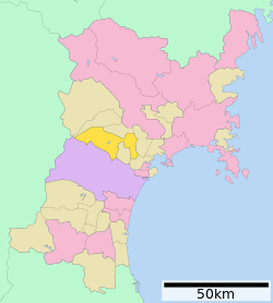 Location of Taiwa in Miyagi Prefecture | |
 Taiwa | |
| Coordinates: 38°26′14.4″N 140°53′10.9″E | |
| Country | Japan |
| Region | Tōhoku |
| Prefecture | Miyagi |
| District | Kurokawa |
| Area | |
| • Total | 225.49 km2 (87.06 sq mi) |
| Population (May 31, 2020) | |
| • Total | 28,436 |
| • Density | 130/km2 (330/sq mi) |
| Time zone | UTC+9 (Japan Standard Time) |
| - Tree | Maple |
| - Flower | Azalea |
| Phone number | 022-345-1111 |
| Address | 1-1 Yoshioka Nishi-Enoki, Taiwa-chō, Kurokawa-gun, Miyagi-ken 981-3680 |
| Website | Official website |

Geography
Taiwa is located in central Miyagi Prefecture, bordered to the south by the metropolis of Sendai. Much of the area of the town is forested.
Neighboring municipalities
Miyagi Prefecture
Climate
The town has a climate characterized by cool summers and long cold winters (Köppen climate classification Cfa). The average annual temperature in Taiwa is 11.6 °C. The average annual rainfall is 1292 mm with September as the wettest month. The temperatures are highest on average in August, at around 24.5 °C, and lowest in January, at around -0.3 °C.[2]
Demographics
Per Japanese census data,[3] the population of Taiwa has grown over the past 50 years.
| Year | Pop. | ±% |
|---|---|---|
| 1920 | 12,960 | — |
| 1930 | 13,882 | +7.1% |
| 1940 | 14,872 | +7.1% |
| 1950 | 19,206 | +29.1% |
| 1960 | 20,163 | +5.0% |
| 1970 | 18,028 | −10.6% |
| 1980 | 18,662 | +3.5% |
| 1990 | 18,814 | +0.8% |
| 2000 | 24,419 | +29.8% |
| 2010 | 28,244 | +15.7% |
| 2020 | 28,786 | +1.9% |
History
The area of present-day Taiwa was part of ancient Mutsu Province, and has been settled since at least the Jōmon period by the Emishi people. Numerous kofun were built in the area during the Kofun period. During later portion of the Heian period, the area was ruled by the Northern Fujiwara. During the Sengoku period, the area was contested by various samurai clans before the area came under the control of the Date clan of Sendai Domain during the Edo period, under the Tokugawa shogunate. Yoshioka-juku developed as a major post station on the Ōshū Kaidō during this time. Following the Meiji restoration, the town of Yoshioka was established with the creation of the modern municipalities system.
The town of Taiwa was created on April 20, 1955, as a result of a merger between the town of Yoshioka, and the villages of Miyatoko, Yoshida, Tsurusu, and Ochiai, all within Kurokawa District.
Government
Taiwa has a mayor-council form of government with a directly elected mayor and a unicameral town council of 18 members. Taiwa, together with the rest of Kurokawa District and the city of Tomiya collectively contributes two seats to the Miyagi Prefectural legislature. In terms of national politics, the town is part of Miyagi 5th district of the lower house of the Diet of Japan.
Economy
Taiwa contains a number of industrial parks, and has a strong manufacturing base.
Education
- Miyagi University
- Taiwa has six public elementary schools and two public high schools operated by the town government, and one public high school operated by the Miyagi Prefectural Board of Education.
Transportation
Railway
Taiwa does not have any passenger railway service.
Highway
 Tōhoku Expressway - Taiwa IC
 National Route 4
 National Route 47
 National Route 457
Local attractions
- Miyatoko Dam
- Minamikawa Dam
- Yoshioka Hachiman Jinja
- Nanatsumori
References
External links
![]() Media related to Taiwa, Miyagi at Wikimedia Commons
Media related to Taiwa, Miyagi at Wikimedia Commons
- Official Website (in Japanese)
Sendai (capital) | |||
| Sendai |
| ||
| Cities | |||
| Districts |
| ||
List of mergers in Miyagi Prefecture | |||
Authority control | |
|---|---|
| General | |
| National libraries | |
| Other |
|
На других языках
- [en] Taiwa, Miyagi
[ru] Тайва
Тайва (яп. 大和町 Тайва-тё:) — посёлок в Японии, находящийся в уезде Курокава префектуры Мияги. Площадь посёлка составляет 225,59 км²[1], население — 27 527 человек (31 июля 2014)[2], плотность населения — 122,02 чел./км².Другой контент может иметь иную лицензию. Перед использованием материалов сайта WikiSort.org внимательно изучите правила лицензирования конкретных элементов наполнения сайта.
WikiSort.org - проект по пересортировке и дополнению контента Википедии