world.wikisort.org - Japan
Hachirōgata (八郎潟町, Hachirōgata-machi) is a town located in Akita, Japan. As of 1 February 2020[update], the town had an estimated population of 5749 in 2465 households,[1] and a population density of 340 persons per km². The total area is 17.00 square kilometres (6.56 sq mi). It is the smallest municipality in Akita Prefecture in terms of surface area.
This article needs additional citations for verification. (October 2022) |
Hachirōgata
八郎潟町 | |
|---|---|
Village | |
 Panorama view of Hachirōgata, from Tennō Sky Tower | |
 Flag  Seal | |
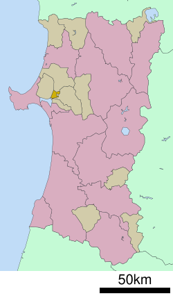 Location of Hachirōgata in Akita Prefecture | |
 Hachirōgata | |
| Coordinates: 39°57′N 140°4′E | |
| Country | Japan |
| Region | Tōhoku |
| Prefecture | Akita |
| District | Minamiakita |
| Government | |
| • Mayor | Kiku Hatayama (from September 2008) |
| Area | |
| • Total | 17.00 km2 (6.56 sq mi) |
| Population (February 2020) | |
| • Total | 5,749 |
| • Density | 340/km2 (880/sq mi) |
| Time zone | UTC+9 (Japan Standard Time) |
| - Tree | Japanese Zelkova |
| - Flower | Azalea |
| Phone number | 018-875-5800 |
| Address | Jidaidō 80, Hachirōgata-machi, Minamiakita-gun, Akita-ken 018-1692 |
| Website | Official website |
Geography
Hachirōgata is located in the coastal flatlands northeastern Akita Prefecture, bordered by the remnant of Lake Hachirōgata which lies in the west of the town. Lake Hachirōgata was the second largest lake in Japan until it was drained in a land reclamation project from 1957 to 1977.
Neighboring municipalities
Demographics
Per Japanese census data,[2] the population of Hachirōgata peaked at around the year 1950 and has been in steady decline since then.
| Year | Pop. | ±% |
|---|---|---|
| 1920 | 5,831 | — |
| 1930 | 6,568 | +12.6% |
| 1940 | 7,166 | +9.1% |
| 1950 | 8,743 | +22.0% |
| 1960 | 8,358 | −4.4% |
| 1970 | 8,180 | −2.1% |
| 1980 | 8,228 | +0.6% |
| 1990 | 8,153 | −0.9% |
| 2000 | 7,533 | −7.6% |
| 2010 | 6,624 | −12.1% |
| 2020 | 5,583 | −15.7% |
Climate
Hachirōgata has a Humid continental climate (Köppen climate classification Cfa) with large seasonal temperature differences, with warm to hot (and often humid) summers and cold (sometimes severely cold) winters. Precipitation is significant throughout the year, but is heaviest from August to October. The average annual temperature in Hachirōgata is 11.1 °C. The average annual rainfall is 1612 mm with September as the wettest month. The temperatures are highest on average in August, at around 24.8 °C, and lowest in January, at around -1.0 °C.
History
The area of present-day Hachirōgata was part of ancient Dewa Province, dominated by the Satake clan during the Edo period, who ruled Kubota Domain under the Tokugawa shogunate. The village of Omogata was established in 1889 with the establishment of the modern municipalities system, the town of Hitoichi in 1925. The two merged in 1956 to form the town of Hachirōgata. Efforts to merge the town with neighboring Gojōme and Ikawa failed to pass a referendum in 2005.
 Hachirōgata Town Hall
 Panoramic view of Hachirōgata and Ōgata, from Oga
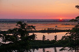 A sunset view of Hachirōgata, from Mikurabana Park
 Hitoichi Bon dancing festival


Economy
The economy of Hachirōgata is based on agriculture.
Education
Hachirōgata has one public elementary schools and one public middle schools operated by the town government. The town does not have a high school.
Transportation
Railway
![]() East Japan Railway Company - Ōu Main Line
East Japan Railway Company - Ōu Main Line
Highway
 Akita Expressway
 National Route 7
Notable peoples
- Chiharu Shida, Japanese national badminton player
References
External links
![]() Media related to Hachirogata, Akita at Wikimedia Commons
Media related to Hachirogata, Akita at Wikimedia Commons
- Official Website (in Japanese)
Akita (capital) | ||
| Core city | ||
| Cities | ||
| Districts |
| |
List of mergers in Akita Prefecture | ||
На других языках
- [en] Hachirōgata, Akita
[es] Hachirōgata (Akita)
Hachirōgata (八郎潟町, Hachirōgata-machi?) es un pueblo localizado en la prefectura de Akita, Japón. En octubre de 2018 tenía una población de 5.763 habitantes y una densidad de población de 339 personas por km². Su área total es de 17,00 km².[ru] Хатирогата
Хатирогата (яп. 八郎潟町 Хатиро:гата-мати) — посёлок в Японии, находящийся в уезде Минамиакита префектуры Акита. Площадь посёлка составляет 17,00 км²[1], население — 6186 человек (1 августа 2014)[2], плотность населения — 363,88 чел./км².Другой контент может иметь иную лицензию. Перед использованием материалов сайта WikiSort.org внимательно изучите правила лицензирования конкретных элементов наполнения сайта.
WikiSort.org - проект по пересортировке и дополнению контента Википедии