world.wikisort.org - Japan
Ōdate (大館市, Ōdate-shi, Japanese: [oːdate]) is a city in Akita Prefecture, Japan. As of 1 January 2020[update], the city has an estimated population of 71,558 in 31,634 households,[1] and a population density of 82 persons per km2 (212 persons per square mile). The total area of the city is 913.22 square kilometres (352.60 sq mi).
This article needs additional citations for verification. (September 2013) |
Ōdate
大館市 | |
|---|---|
City | |
 Panorama view of Ōdate | |
 Flag  Seal | |
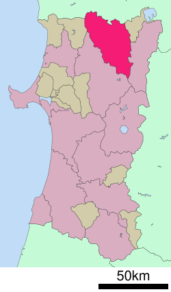 Location of Ōdate in Akita Prefecture | |
 Ōdate | |
| Coordinates: 40°16′17″N 140°33′51″E | |
| Country | Japan |
| Region | Tōhoku |
| Prefecture | Akita |
| Government | |
| • -Mayor | Hajime Obata |
| Area | |
| • Total | 913.22 km2 (352.60 sq mi) |
| Population (January 2020) | |
| • Total | 71,558 |
| • Density | 78/km2 (200/sq mi) |
| Time zone | UTC+9 (Japan Standard Time) |
| Phone number | 0186-49-3111 |
| Address | 20 Nakajō, Ōdate-shi, Akita-ken 017-8555 |
| Climate | Cfa/Dfa |
| Website | Official website |
| Symbols | |
| Flower | Chrysanthemum |
| Tree | Akita sugi |

Geography
Ōdate is located in the mountains of northern Akita Prefecture, with the Ōu Mountains on the east and Aomori Prefecture to the north. The city is a basin surrounded by mountains on all sides. Part of the city is within the borders of the Towada-Hachimantai National Park. Much of the city area is covered in forest. Due to its inland location, the city is noted for its heavy snowfall in winter.
Neighboring municipalities
- Akita Prefecture
- Aomori Prefecture
- Hirosaki
- Hirakawa
- Owani
- Nishimeya
Climate
Ōdate has a Humid continental climate (Köppen climate classification Dfa) with large seasonal temperature differences, with warm to hot (and often humid) summers and cold (sometimes severely cold) winters. Precipitation is significant throughout the year, but is heaviest from August to October. The average annual temperature in Ōdate is 10.3 °C (50.5 °F). The average annual rainfall is 1,741.0 mm (68.54 in) with July as the wettest month. The temperatures are highest on average in August, at around 23.6 °C (74.5 °F), and lowest in January, at around −2.0 °C (28.4 °F).[2]
| Climate data for Ōdate (1991−2020 normals, extremes 1976−present) | |||||||||||||
|---|---|---|---|---|---|---|---|---|---|---|---|---|---|
| Month | Jan | Feb | Mar | Apr | May | Jun | Jul | Aug | Sep | Oct | Nov | Dec | Year |
| Record high °C (°F) | 10.8 (51.4) |
17.6 (63.7) |
20.8 (69.4) |
30.8 (87.4) |
33.2 (91.8) |
35.1 (95.2) |
37.5 (99.5) |
38.3 (100.9) |
37.0 (98.6) |
28.6 (83.5) |
23.3 (73.9) |
16.2 (61.2) |
38.3 (100.9) |
| Average high °C (°F) | 1.6 (34.9) |
2.9 (37.2) |
7.1 (44.8) |
14.8 (58.6) |
20.8 (69.4) |
24.7 (76.5) |
27.6 (81.7) |
29.0 (84.2) |
24.9 (76.8) |
18.2 (64.8) |
10.9 (51.6) |
4.0 (39.2) |
15.5 (60.0) |
| Daily mean °C (°F) | −2.0 (28.4) |
−1.4 (29.5) |
2.0 (35.6) |
8.2 (46.8) |
14.4 (57.9) |
18.8 (65.8) |
22.5 (72.5) |
23.6 (74.5) |
19.0 (66.2) |
12.0 (53.6) |
5.7 (42.3) |
0.2 (32.4) |
10.3 (50.5) |
| Average low °C (°F) | −5.9 (21.4) |
−5.8 (21.6) |
−2.7 (27.1) |
2.3 (36.1) |
8.7 (47.7) |
13.9 (57.0) |
18.6 (65.5) |
19.4 (66.9) |
14.5 (58.1) |
7.0 (44.6) |
1.3 (34.3) |
−3.1 (26.4) |
5.7 (42.2) |
| Record low °C (°F) | −19.0 (−2.2) |
−17.9 (−0.2) |
−14.9 (5.2) |
−8.5 (16.7) |
−2.1 (28.2) |
4.6 (40.3) |
9.4 (48.9) |
9.9 (49.8) |
2.7 (36.9) |
−2.1 (28.2) |
−8.0 (17.6) |
−15.8 (3.6) |
−19.0 (−2.2) |
| Average precipitation mm (inches) | 108.2 (4.26) |
92.6 (3.65) |
106.1 (4.18) |
118.5 (4.67) |
126.4 (4.98) |
121.6 (4.79) |
216.6 (8.53) |
214.0 (8.43) |
164.8 (6.49) |
163.2 (6.43) |
162.0 (6.38) |
139.2 (5.48) |
1,741 (68.54) |
| Average precipitation days (≥ 1.0 mm) | 19.8 | 17.0 | 15.7 | 12.7 | 12.4 | 10.4 | 13.0 | 11.7 | 12.3 | 14.8 | 17.2 | 20.2 | 177.2 |
| Mean monthly sunshine hours | 59.2 | 82.7 | 132.0 | 165.9 | 185.6 | 174.9 | 147.4 | 176.4 | 145.9 | 131.2 | 91.1 | 57.9 | 1,541.5 |
| Source: Japan Meteorological Agency[3][2] | |||||||||||||
Demographics
Per Japanese census data,[4] the population of Ōdate peaked in the 1960s and has been in decline since then.
| Year | Pop. | ±% |
|---|---|---|
| 1920 | 64,055 | — |
| 1930 | 70,629 | +10.3% |
| 1940 | 75,333 | +6.7% |
| 1950 | 96,841 | +28.6% |
| 1960 | 103,531 | +6.9% |
| 1970 | 97,856 | −5.5% |
| 1980 | 95,529 | −2.4% |
| 1990 | 90,098 | −5.7% |
| 2000 | 86,288 | −4.2% |
| 2010 | 78,951 | −8.5% |
| 2020 | 69,237 | −12.3% |
History
The area of present-day Ōdate was part of ancient Dewa Province, although it remained outside of the control of the Yamato court until well into the Heian period. During the Edo period, the area came under the control of the Satake clan, who ruled the northern third of the province from Kubota Domain, and who maintained a secondary fortification at Ōdate Castle. The castle was destroyed during the Boshin War. [citation needed].
After the start of the Meiji period, the area became part of Kitaakita District, Akita Prefecture in 1878. The town of Ōdate was established on April 1, 1889 with the establishment of the modern municipalities system. During the Meiji period, the discovery of "black ore" (sphalerite and galena - a mixture of zinc, lead, gold, silver, and other precious metals), led to the development of numerous mines in the area, including the Hanaoka mine;[5] however, the deposits were depleted by the mid-Shōwa period.
On June 20, 2005, the towns of Hinai and Tashiro (both from Kitaakita District) were merged into Ōdate.
Government
Ōdate has a mayor-council form of government with a directly elected mayor and a unicameral city legislature of 26 members. The city contributes three members to the Akita Prefectural Assembly. In terms of national politics, the city is part of Akita District 2 of the lower house of the Diet of Japan.
Economy

The economy of Ōdate is based on agriculture, forestry and seasonal tourism.
Education
- Akita University of Nursing and Welfare
- Ōdate has 17 public elementary schools and eight public middle schools operated by the city government, and one national junior high school. The city has three public high schools operated by the Akita Prefectural Board of Education. The prefecture also operates three special education schools for the handicapped.
Transportation
Airports
- Odate-Noshiro Airport
Railway
![]() East Japan Railway Company - Ōu Main Line
East Japan Railway Company - Ōu Main Line
- Hayaguchi - Shimokawazoi - Ōdate - Shirasawa - Jimba
![]() East Japan Railway Company - Hanawa Line
East Japan Railway Company - Hanawa Line
- Sawajiri - Jūnisho - Ōtaki-Onsen - Ōgita - Higashi-Ōdate - Ōdate
Highways
 Akita Expressway
 National Route 7
 National Route 103
 National Route 285
Notable people from Ōdate
This section does not cite any sources. (September 2013) |
- Ginko Abukawa-Chiba, gymnast
- Yasushi Akashi, United Nations administrator, January 2001 – June 2003
- Shoeki Ando, philosopher
- Hirohide Ishida, politician
- Hiroshi Ishikawa, film director
- Takiji Kobayashi, writer
- Fuyukichi Maki, actor
- Masahiko Nagasawa, film director
- Nobuhiro Omiya, politician
- Takuya Sugawara, professional wrestler
- Dick Togo, professional wrestler
- Bin Uehara, singer
- Keizo Yamada, long-distance runner
References
- Ōdate City official statistics (in Japanese)
- 気象庁 / 平年値(年・月ごとの値). JMA. Retrieved March 25, 2022.
- 観測史上1~10位の値(年間を通じての値). JMA. Retrieved March 25, 2022.
- Ōdate population statistics
- "Mineral deposits of Northern Asia". docstoc.com. 2012. Retrieved 2013-07-10.
External links
- Official Website (in Japanese)
Akita (capital) | ||
| Core city | ||
| Cities | ||
| Districts | ||
List of mergers in Akita Prefecture | ||
Authority control | |
|---|---|
| General | |
| National libraries | |
| Other |
|
На других языках
- [en] Ōdate
[ru] Одате
О́дате[1][2] (яп. 大館市 О:датэ-си) — город в Японии, расположенный в северной части префектуры Акита на территории одноимённой впадины. Основан 1 мая 1954 года путём слияния посёлка Одате и села Сяканай уезда Китаакита. 20 июня 2005 года Одате поглотил посёлки Хинай и Тасиро. Город специализируется на выращивании акитских криптомерий и деревообработке. Город обслуживается близлежащим аэропортом Одате-Носиро.Другой контент может иметь иную лицензию. Перед использованием материалов сайта WikiSort.org внимательно изучите правила лицензирования конкретных элементов наполнения сайта.
WikiSort.org - проект по пересортировке и дополнению контента Википедии