world.wikisort.org - Japan
Amakusa (天草市, Amakusa-shi) is a city located in Kumamoto Prefecture, Japan.
This article needs additional citations for verification. (May 2009) |
Amakusa
天草市 | |
|---|---|
City | |
 Panorama view of Amakusa, from Jyunkyō Park | |
 Flag  Emblem | |
 Location of Amakusa in Kumamoto Prefecture | |
 | |
 Amakusa Location in Japan | |
| Coordinates: 32°28′N 130°12′E | |
| Country | Japan |
| Region | Kyushu |
| Prefecture | Kumamoto Prefecture |
| Hondo City Settled | April 1, 1954 |
| Ushibuka City Settled | July 1, 1954 |
| Both Cities Mergerd | March 27, 2006[citation needed] |
| Government | |
| • Mayor | Shoji Baba |
| Area | |
| • Total | 683.17 km2 (263.77 sq mi) |
| Population (March 31, 2017) | |
| • Total | 83,082 |
| • Density | 120/km2 (310/sq mi) |
| Time zone | UTC+09:00 (JST) |
| City hall address | 8-1 Higashihamamachi, Amakusa-shi, Kumamoto-ken 863-0014 |
| Climate | Cfa |
| Website | www |
| Symbols | |
| Bird | Larus canus |
| Flower | Hibiscus hamabo |
| Tree | Ficus superba |
| Amakusa | |||||
|---|---|---|---|---|---|
| Japanese name | |||||
| Kanji | 天草市 | ||||
| Hiragana | あまくさし | ||||
| Katakana | アマクサシ | ||||
| |||||

As of March 31, 2017, Amakusa has an estimated population of 83,082[1] and a population density of 120 persons per km2. The total area is 683.17 km (424.50 mi). Amakusa has the distinction of being the fastest depopulating city in Japan since the last census (2005).[citation needed]
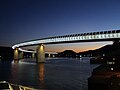 A night view of Ushibuka Haiya Bridge
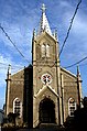 Sakitsu Catholic Church


Amakusa covers the majority of two main islands, Kamishima (上島, "Upper Island") and Shimoshima (下島, "Lower Island") (天草諸島), and six smaller islands and islets. The modern city of Amakusa was established on March 27, 2006, from a merger between the former cities of Hondo and Ushibuka, and the towns of Amakusa , Ariake, Goshoura, Itsuwa, Kawaura, Kuratake, Shinwa and Sumoto from Amakusa District.[citation needed]
Amakusa Airlines is headquartered in Amakusa.[2]
Geography
Climate
Amakusa has a humid subtropical climate (Köppen climate classification Cfa) with hot summers and cool winters. Precipitation is significant throughout the year, and is heaviest from May to August. The average annual temperature in Amakusa is 18.2 °C (64.8 °F). The average annual rainfall is 2,109.8 mm (83.06 in) with June as the wettest month. The temperatures are highest on average in August, at around 28.3 °C (82.9 °F), and lowest in January, at around 8.6 °C (47.5 °F).[3] The highest temperature ever recorded in Amakusa was 39.6 °C (103.3 °F) on 20 August 2013; the coldest temperature ever recorded was −7.0 °C (19.4 °F) on 25 January 2016.[4]
| Climate data for Ushibuka, Amakusa (1991−2020 normals, extremes 1949−present) | |||||||||||||
|---|---|---|---|---|---|---|---|---|---|---|---|---|---|
| Month | Jan | Feb | Mar | Apr | May | Jun | Jul | Aug | Sep | Oct | Nov | Dec | Year |
| Record high °C (°F) | 21.8 (71.2) |
23.6 (74.5) |
24.5 (76.1) |
29.2 (84.6) |
31.2 (88.2) |
33.9 (93.0) |
37.5 (99.5) |
39.6 (103.3) |
36.7 (98.1) |
34.0 (93.2) |
27.8 (82.0) |
24.0 (75.2) |
39.6 (103.3) |
| Average high °C (°F) | 11.8 (53.2) |
13.0 (55.4) |
16.1 (61.0) |
20.3 (68.5) |
24.2 (75.6) |
26.5 (79.7) |
30.4 (86.7) |
32.2 (90.0) |
29.6 (85.3) |
25.0 (77.0) |
19.6 (67.3) |
14.2 (57.6) |
21.9 (71.4) |
| Daily mean °C (°F) | 8.6 (47.5) |
9.4 (48.9) |
12.2 (54.0) |
16.3 (61.3) |
20.1 (68.2) |
23.1 (73.6) |
27.0 (80.6) |
28.3 (82.9) |
25.6 (78.1) |
21.1 (70.0) |
16.0 (60.8) |
10.8 (51.4) |
18.2 (64.8) |
| Average low °C (°F) | 5.5 (41.9) |
6.0 (42.8) |
8.6 (47.5) |
12.6 (54.7) |
16.6 (61.9) |
20.5 (68.9) |
24.3 (75.7) |
25.4 (77.7) |
22.7 (72.9) |
17.8 (64.0) |
12.8 (55.0) |
7.6 (45.7) |
15.0 (59.1) |
| Record low °C (°F) | −3.0 (26.6) |
−3.4 (25.9) |
−1.6 (29.1) |
2.0 (35.6) |
9.4 (48.9) |
12.6 (54.7) |
18.0 (64.4) |
18.8 (65.8) |
14.1 (57.4) |
7.4 (45.3) |
2.8 (37.0) |
−1.5 (29.3) |
−3.4 (25.9) |
| Average precipitation mm (inches) | 79.7 (3.14) |
95.4 (3.76) |
124.7 (4.91) |
158.1 (6.22) |
178.7 (7.04) |
409.6 (16.13) |
348.9 (13.74) |
200.7 (7.90) |
204.0 (8.03) |
96.5 (3.80) |
106.5 (4.19) |
96.4 (3.80) |
2,109.8 (83.06) |
| Average snowfall cm (inches) | 1 (0.4) |
1 (0.4) |
0 (0) |
0 (0) |
0 (0) |
0 (0) |
0 (0) |
0 (0) |
0 (0) |
0 (0) |
0 (0) |
0 (0) |
1 (0.4) |
| Average precipitation days (≥ 1.0 mm) | 10.6 | 9.6 | 11.1 | 10.0 | 9.5 | 14.3 | 10.4 | 9.5 | 9.5 | 6.5 | 8.6 | 10.0 | 119.6 |
| Average snowy days (≥ 1 cm) | 0.3 | 0.4 | 0 | 0 | 0 | 0 | 0 | 0 | 0 | 0 | 0 | 0 | 0.7 |
| Average relative humidity (%) | 65 | 64 | 66 | 69 | 73 | 82 | 82 | 77 | 73 | 66 | 67 | 65 | 71 |
| Mean monthly sunshine hours | 105.4 | 121.7 | 160.9 | 180.9 | 189.7 | 124.1 | 193.1 | 227.9 | 192.0 | 191.0 | 147.2 | 118.4 | 1,954.5 |
| Source: Japan Meteorological Agency[4][3] | |||||||||||||
| Climate data for Hondo, Amakusa (1991−2020 normals, extremes 1977−present) | |||||||||||||
|---|---|---|---|---|---|---|---|---|---|---|---|---|---|
| Month | Jan | Feb | Mar | Apr | May | Jun | Jul | Aug | Sep | Oct | Nov | Dec | Year |
| Record high °C (°F) | 22.0 (71.6) |
23.2 (73.8) |
25.1 (77.2) |
29.5 (85.1) |
32.6 (90.7) |
35.2 (95.4) |
37.3 (99.1) |
37.6 (99.7) |
35.5 (95.9) |
33.3 (91.9) |
27.0 (80.6) |
25.1 (77.2) |
37.6 (99.7) |
| Average high °C (°F) | 10.7 (51.3) |
12.2 (54.0) |
15.5 (59.9) |
20.7 (69.3) |
25.2 (77.4) |
27.3 (81.1) |
31.3 (88.3) |
32.5 (90.5) |
29.1 (84.4) |
24.0 (75.2) |
18.4 (65.1) |
12.9 (55.2) |
21.7 (71.0) |
| Daily mean °C (°F) | 6.2 (43.2) |
7.2 (45.0) |
10.3 (50.5) |
14.9 (58.8) |
19.2 (66.6) |
22.6 (72.7) |
26.5 (79.7) |
27.3 (81.1) |
24.0 (75.2) |
18.9 (66.0) |
13.4 (56.1) |
8.3 (46.9) |
16.6 (61.8) |
| Average low °C (°F) | 2.1 (35.8) |
2.6 (36.7) |
5.3 (41.5) |
9.5 (49.1) |
14.0 (57.2) |
18.8 (65.8) |
22.9 (73.2) |
23.4 (74.1) |
20.2 (68.4) |
14.6 (58.3) |
9.1 (48.4) |
4.1 (39.4) |
12.2 (54.0) |
| Record low °C (°F) | −7.0 (19.4) |
−5.6 (21.9) |
−3.1 (26.4) |
0.4 (32.7) |
6.4 (43.5) |
10.9 (51.6) |
16.6 (61.9) |
17.5 (63.5) |
11.7 (53.1) |
3.4 (38.1) |
−0.2 (31.6) |
−3.2 (26.2) |
−7.0 (19.4) |
| Average precipitation mm (inches) | 83.1 (3.27) |
96.1 (3.78) |
132.6 (5.22) |
157.2 (6.19) |
169.9 (6.69) |
405.3 (15.96) |
340.5 (13.41) |
215.0 (8.46) |
195.4 (7.69) |
111.9 (4.41) |
108.4 (4.27) |
91.6 (3.61) |
2,106.3 (82.93) |
| Average precipitation days (≥ 1.0 mm) | 9.9 | 9.8 | 10.8 | 10.2 | 9.5 | 15.1 | 12.3 | 10.5 | 10.1 | 7.1 | 9.1 | 9.9 | 124.3 |
| Mean monthly sunshine hours | 108.8 | 126.6 | 163.1 | 183.7 | 190.7 | 119.2 | 178.2 | 216.0 | 179.8 | 184.3 | 142.4 | 120.9 | 1,915.7 |
| Source: Japan Meteorological Agency[5][6] | |||||||||||||
Demographics
Per Japanese census data, the population of Amakusa in 2020 is 75,783 people.[7] Amakusa has been conducting censuses since 1920.
| Year | Pop. | ±% |
|---|---|---|
| 1920 | 122,297 | — |
| 1925 | 121,482 | −0.7% |
| 1930 | 125,165 | +3.0% |
| 1935 | 123,495 | −1.3% |
| 1940 | 123,580 | +0.1% |
| 1945 | 167,936 | +35.9% |
| 1950 | 169,508 | +0.9% |
| 1955 | 169,880 | +0.2% |
| 1960 | 158,882 | −6.5% |
| 1965 | 142,346 | −10.4% |
| 1970 | 127,636 | −10.3% |
| 1975 | 122,513 | −4.0% |
| 1980 | 121,574 | −0.8% |
| 1985 | 118,765 | −2.3% |
| 1990 | 112,068 | −5.6% |
| 1995 | 107,823 | −3.8% |
| 2000 | 102,907 | −4.6% |
| 2005 | 96,473 | −6.3% |
| 2010 | 89,091 | −7.7% |
| 2015 | 82,739 | −7.1% |
| 2020 | 75,783 | −8.4% |
| Amakusa population statistics[7] | ||
Tourism
Sightseeing Spots
- Alegria Gardens [citation needed]
- Amakusa Christian Museum
- Amakusa Dolphin Marine Land [citation needed]
- Ōe Catholic Church
- Sakitsu Church
- Shimoda Onsen hot springs
 Amakusa Christian Museum
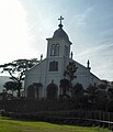 Ōe Catholic Church
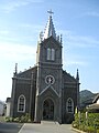 Sakitsu Catholic Church
 Shimoda Onsen hot springs


Notable people
- Sunao Sonoda, statesman
- Hiroyuki Sonoda, statesman
- Kundō Koyama, film writer
- Michiko Ishimure, writer
- Tochihikari Masayuki, sumo wrestler
- Yoshiki Tanaka, novelist
- Kenta Matsumoto, vocalist and bassist of WANIMA
- Koushin Nishida, guitarist of WANIMA
Sister Cities
 Encinitas, California, United States[8]
References
- "Official website of Amakusa City" (in Japanese). Japan: Amakusa City. Retrieved 30 April 2017.
- "AMX会社概要 Archived 2009-08-04 at the Wayback Machine." Amakusa Airlines. Retrieved on May 20, 2009.
- 気象庁 / 平年値(年・月ごとの値). JMA. Retrieved February 27, 2022.
- 観測史上1~10位の値(年間を通じての値). JMA. Retrieved February 27, 2022.
- 観測史上1~10位の値(年間を通じての値). JMA. Retrieved April 16, 2022.
- 気象庁 / 平年値(年・月ごとの値). JMA. Retrieved April 16, 2022.
- Amakusa population statistics
- "City of Encinitas : Sister City Program". Archived from the original on 2012-07-14. Retrieved 2012-08-14.
External links
 Media related to Amakusa, Kumamoto at Wikimedia Commons
- Amakusa City official website (in Japanese)
 Geographic data related to Amakusa, Kumamoto at OpenStreetMap
Kumamoto (capital) | ||||
| Kumamoto |
| |||
| Cities | ||||
| Districts |
| |||
List of mergers in Kumamoto Prefecture | ||||
Authority control | |
|---|---|
| General | |
| National libraries | |
| Scientific databases | |
| Other |
|
На других языках
[de] Amakusa (Kumamoto)
Amakusa (jap. .mw-parser-output .Hani{font-size:110%}天草市, -shi; wörtlich: Himmelsgras) ist eine Stadt in der Präfektur Kumamoto auf den Amakusa-Inseln in Japan.- [en] Amakusa, Kumamoto
[ru] Амакуса (город)
Ама́куса[1] (яп. 天草市 Амакуса-си) — город в Японии, находящийся в префектуре Кумамото. Площадь города составляет 683,28 км²[2], население — 83 657 человек (1 августа 2014)[3], плотность населения — 122,43 чел./км².Другой контент может иметь иную лицензию. Перед использованием материалов сайта WikiSort.org внимательно изучите правила лицензирования конкретных элементов наполнения сайта.
WikiSort.org - проект по пересортировке и дополнению контента Википедии