world.wikisort.org - Italy
St. Lorenzen (German pronunciation: [saŋkt loˈrɛntsn̩]; Italian: San Lorenzo di Sebato [san loˈrɛntso di seˈbaːto]) is a comune (municipality) in South Tyrol in northern Italy, located about 50 kilometers (31 mi) northeast of Bolzano. As of 30 November 2010, it had a population of 3,752 and an area of 51.5 km2 (19.9 sq mi).[3]
St. Lorenzen | |
|---|---|
Comune | |
| Marktgemeinde St. Lorenzen Comune di San Lorenzo di Sebato | |
 | |
 Coat of arms | |
Location of St. Lorenzen  | |
 St. Lorenzen Location of St. Lorenzen in Italy  St. Lorenzen St. Lorenzen (Trentino-Alto Adige/Südtirol) | |
| Coordinates: 46°47′N 11°54′E | |
| Country | Italy |
| Region | Trentino-Alto Adige/Südtirol |
| Province | South Tyrol (BZ) |
| Frazioni | Ellen (Elle), Fassing (Fassine), Runggen (Ronchi), Montal (Mantana), Pflaurenz (Floronzo), Saalen (Sares), Sonnenburg (Castelbadia), Stefansdorf (Sante Stefano), St Martin (San Martino), Moos (Palù), Lothen, Onach |
| Government | |
| • Mayor | Martin Ausserdorfer |
| Area | |
| • Total | 51.5 km2 (19.9 sq mi) |
| Elevation | 810 m (2,660 ft) |
| Population (November 2010)[2] | |
| • Total | 3,752 |
| • Density | 73/km2 (190/sq mi) |
| Demonym(s) | German: Lorenzner Italian: Lorenzesi |
| Time zone | UTC+1 (CET) |
| • Summer (DST) | UTC+2 (CEST) |
| Postal code | 39030 |
| Dialing code | 0474 |
| Website | Official website |

St Lorenzen borders the following municipalities: Bruneck, Kiens, Pfalzen, Lüsen, Mareo, and Rodeneck.
Geography
As of 30 November 2010, it had a population of 3,752 and an area of 51.5 km2 (19.9 sq mi).[3]
The municipality of St Lorenzen contains the frazioni (subdivisions, mainly villages and hamlets) Ellen (Elle), Fassing (Fassine), Runggen (Ronchi), Montal (Mantana), Pflaurenz (Floronzo), Saalen (Sares), Sonnenburg (Castelbadia), Stefansdorf (Sante Stefano), St Martin (San Martino), Moos (Palù), Lothen, and Onach.
St Lorenzen borders the following municipalities: Bruneck, Kiens, Pfalzen, Lüsen, Mareo, and Rodeneck.
History
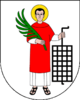
Coat of arms
The emblem represents Saint Laurence, with a vert palm in his right hand and a grill on the left, on argent. The emblem is used by the 17th century, but appears in the seal since 1271.[4]
Society
Linguistic distribution
According to the 2011 census, 95.31% of the population speak German, 2.64% Italian and 1.34% Ladin as first language.[5]
Demographic evolution

Culture
Notable people
- Jakob Hutter
References
- "Superficie di Comuni Province e Regioni italiane al 9 ottobre 2011". Italian National Institute of Statistics. Retrieved 16 March 2019.
- "Popolazione Residente al 1° Gennaio 2018". Italian National Institute of Statistics. Retrieved 16 March 2019.
- All demographics and other statistics: Italian statistical institute ISTAT.
- Heraldry of the World: St. Lorenzen
- "Volkszählung 2011/Censimento della popolazione 2011". astat info. Provincial Statistics Institute of the Autonomous Province of South Tyrol (38): 6–7. June 2012. Retrieved 2012-06-14.
External links
![]() Media related to St. Lorenzen at Wikimedia Commons
Media related to St. Lorenzen at Wikimedia Commons
- (in German and Italian) Homepage of the municipality

Authority control | |
|---|---|
| General | |
| National libraries | |
| Other |
|
На других языках
- [en] St. Lorenzen
[es] San Lorenzo di Sebato
San Lorenzo di Sebato es una localidad y comune italiana de la provincia de Bolzano, región de Trentino-Alto Adigio, con 3.572 habitantes.[ru] Сан-Лоренцо-ди-Себато
Сан-Лоренцо-ди-Себато (Санкт-Лоренцен, итал. San Lorenzo di Sebato, нем. St. Lorenzen) — коммуна в Италии, располагается в регионе Трентино — Альто-Адидже, подчиняется административному центру Больцано.Другой контент может иметь иную лицензию. Перед использованием материалов сайта WikiSort.org внимательно изучите правила лицензирования конкретных элементов наполнения сайта.
WikiSort.org - проект по пересортировке и дополнению контента Википедии