world.wikisort.org - Italy
Neumarkt (literally "new market"; German: [ˈnɔɪ̯markt] (![]() listen); Italian: Egna [ˈeɲɲa]) is a comune (municipality) in South Tyrol in northern Italy, located about 25 kilometres (16 mi) south of the city of Bolzano.
listen); Italian: Egna [ˈeɲɲa]) is a comune (municipality) in South Tyrol in northern Italy, located about 25 kilometres (16 mi) south of the city of Bolzano.
Comune | |
| Gemeinde Neumarkt Comune di Egna | |
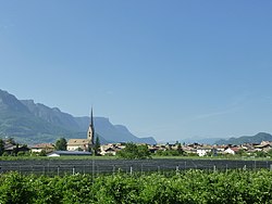
 View from the south | |
 Location of Neumarkt/Egna in the province of South Tyrol. | |
| Coordinates: 46°19′1″N 11°16′1″E | |
| Country | Italy |
| Region | Trentino-Alto Adige/Südtirol |
| Province | South Tyrol (BZ) |
| Frazioni | Laag (Laghetti), Mazon (Mazzon), St. Florian (San Floriano), Vill (Villa) |
| Government | |
| • Mayor | Karin Jost (South Tyrolean People's Party) |
| Area | |
| • Total | 23 km2 (9 sq mi) |
| Elevation | 214 m (702 ft) |
| Population (Nov. 2010)[2] | |
| • Total | 5,001 |
| • Density | 220/km2 (560/sq mi) |
| Demonym(s) | German: Neumarktner Italian: egnesi |
| Time zone | UTC+1 (CET) |
| • Summer (DST) | UTC+2 (CEST) |
| Postal code | 39044 |
| Dialing code | 0471 |
| Saint day | 6 December |
| Website | Official website |
Geography
As of 30 November 2010, it had a population of 5,001 and an area of 23 square kilometres (8.9 sq mi).[3]
Neumarkt borders the following municipalities: Kaltern, Kurtatsch, Kurtinig, Margreid, Montan, Salorno and Tramin.
Neumarkt is the chief town of the Überetsch-Unterland district. It is the main cultural, historical and artistic center with a very nice old town. The agglomeration includes the neighborhoods of Vill, Laag and Mazon. In the entire district Neumarkt is only the third most populated town after Laives and Eppan, which are agglomerated to the capital city Bolzano.
The town is situated on the plain, elevation 214 metres (702 ft), on the left side of the Adige river.
Neumarkt was a Roman village on the Claudia Augusta road; it was called Endidae [citation needed]. The sightseeing include the arcades of the old town, the parish church, the Local Culture Museum and the church of Vill.
Frazioni
The municipality of Neumarkt contains the frazioni (subdivisions, mainly villages and hamlets) Laag (Laghetti), Mazon (Mazzon), St. Florian (San Floriano) and Vill (Villa).
History
Coat-of-arms
The escutcheon is party per pale, the left side represents the argent crescent moon on a gules background; in the right side a gules cross, with shortened arms, on aa argent background. In a document dated 1395 Albrecht of Austria, brother of Duke Rudolf IV of Austria granted to the village, then called Newnmarkt, the use of the arms. The emblem was granted in 1967.[4]
Society
Linguistic distribution
According to the 2011 census, 62.70% of the population speak German, 36.89% Italian and 0.42% Ladin as first language.[5]
Notable people
- Lilli Gruber (born 1957 in Neumarkt), journalist and former politician
Further reading
- Josef Fontana (1993). Neumarkt 1848–1970: ein Beitrag zur Zeitgeschichte des Unterlandes. Bozen 1993, ISBN 88-7014-732-0.
- Hannes Obermair (1993). Die Urkunden des Dekanatsarchives Neumarkt (Südtirol) 1297–1841. (= Schlern-Schriften 289). Innsbruck: Wagner 1993, ISBN 3-7030-0261-1.
- Helmut Gritsch (1997). Neumarkt an der Etsch – Vergangenheit und Gegenwart. Hrsg. vom Verein für die Ortspflege Neumarkt, Neumarkt 1997 (online).
- Martin Lercher (2005). Die Kirchen von Neumarkt. Pluristamp, Bozen 2005.
References
- "Superficie di Comuni Province e Regioni italiane al 9 ottobre 2011". Italian National Institute of Statistics. Retrieved 16 March 2019.
- "Popolazione Residente al 1° Gennaio 2018". Italian National Institute of Statistics. Retrieved 16 March 2019.
- All demographics and other statistics: Italian statistical institute Istat.
- Heraldry of the World: Neumarkt
- "Volkszählung 2011/Censimento della popolazione 2011". astat info. Provincial Statistics Institute of the Autonomous Province of South Tyrol (38): 6–7. June 2012. Retrieved 2012-06-14.
External links
- (in German and Italian) Homepage of the municipality
- Neumarkt Tourist Information
![]() Media related to Neumarkt, South Tyrol at Wikimedia Commons
Media related to Neumarkt, South Tyrol at Wikimedia Commons
На других языках
- [en] Neumarkt, South Tyrol
[es] Egna
.mw-parser-output .infobox .imagen{max-width:100%;margin:0 auto}.mw-parser-output .infobox .imagen img{max-width:100%;height:auto}body.skin-timeless .mw-parser-output .infobox .imagen a.image>img{max-width:100%!important;height:auto!important}Egna (Neumarkt) Entidad subnacional Egna (Neumarkt)Localización de Egna (Neumarkt) en Italia Ubicación de Egna (Neumarkt)Coordenadas 46°19′04″N 11°16′24″EIdioma oficial ItalianoEntidad Municipio de Italia • País Italia • Región Trentino-Alto Adigio • Provincia BolzanoFracciones Laghetti, Mazzon, San Floriano, VillaMunicipios limítrofes Caldaro sulla Strada del Vino, Cortaccia sulla Strada del Vino, Cortina sulla Strada del Vino, Magrè sulla Strada del Vino, Montagna, Salorno, Termeno sulla Strada del VinoSuperficie • Total 23 km²Altitud • Media 214 m s. n. m.Población (2005) • Total 4,648 hab. • Densidad 202 hab/km²Gentilicio egnesi o egnatiHuso horario CET (UTC +1) • en verano CEST (UTC +2)Código postal 39044[1]Prefijo telefónico 0471Matrícula BZCódigo ISTAT 021029Código catastral D392[2]Fiestas mayores 6 de diciembrePatrono(a) San Nicolás Sitio web oficial [editar datos en Wikidata] Egna vista desde el Passo della Mendola. Localización de Egna en la Provincia de Bolzano. Egna (en alemán Neumarkt) es un municipio de 4.648 habitantes perteneciente a la Provincia Autónoma de Bolzano. El 60% de sus habitantes tiene como lengua materna el alemán. Aparte de ser el centro principal del subcomprensorio de la Bassa Atesina, es la capital administrativa y cultural del comprensorio Oltradige-Bassa Atesina, a pesar de que solo sea el tercer municipio más poblado (después de Laives y Appiano).[ru] Энья
Энья (итал. Egna, нем. Neumarkt — Ноймаркт) — коммуна в Италии, располагается в регионе Трентино — Альто-Адидже, в провинции Больцано.Другой контент может иметь иную лицензию. Перед использованием материалов сайта WikiSort.org внимательно изучите правила лицензирования конкретных элементов наполнения сайта.
WikiSort.org - проект по пересортировке и дополнению контента Википедии


