world.wikisort.org - Ireland
Rahara (Irish: Ráth Ara, meaning 'fort of the charioteer')[1] is a village in County Roscommon, Ireland. It lies on the R362 regional road, between Athlone and Athleague about 3 km (1.9 mi) north of the village of Curraghboy.
This article needs additional citations for verification. (October 2021) |
Rahara
Ráth Ara | |
|---|---|
Village | |
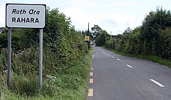
 Rahara on the R362 | |
 Rahara Location in Ireland | |
| Coordinates: 53°31′16″N 8°08′24″W | |
| Country | Ireland |
| Province | Connacht |
| County | County Roscommon |
| Time zone | UTC+0 (WET) |
| • Summer (DST) | UTC-1 (IST (WEST)) |
As of December 2011, the local primary school, Rahara National School, had an enrollment of 34 children.[2] The Roman Catholic church in Rahara, the Church of Mary Immaculate, is in the combined parish of Knockcroghery, St. John's and Rahara of the Diocese of Elphin.[3]
See also
- List of towns and villages in Ireland
References
- "Ráth Ara/Rahara". logainm.ie. Placenames Database of Ireland. Retrieved 14 October 2021.
- "Whole School Evaluation Report - Rahara National School". gov.ie. Department of Education. 6 December 2011. Retrieved 26 February 2022.
- "Parish Details - Knockcroghery / St. John's / Rahara". elphindiocese.ie. Diocese of Elphin. Retrieved 26 February 2022.

На других языках
- [en] Rahara
[ru] Рахара
Рахара[1] (англ. Rahara; ирл. Rath Ara)[2] — деревня в Ирландии, находится в графстве Роскоммон (провинция Коннахт) у трассы R362 между Атлоном и Атлигом, примерно в трёх километрах от Каррабоя.Текст в блоке "Читать" взят с сайта "Википедия" и доступен по лицензии Creative Commons Attribution-ShareAlike; в отдельных случаях могут действовать дополнительные условия.
Другой контент может иметь иную лицензию. Перед использованием материалов сайта WikiSort.org внимательно изучите правила лицензирования конкретных элементов наполнения сайта.
Другой контент может иметь иную лицензию. Перед использованием материалов сайта WikiSort.org внимательно изучите правила лицензирования конкретных элементов наполнения сайта.
2019-2025
WikiSort.org - проект по пересортировке и дополнению контента Википедии
WikiSort.org - проект по пересортировке и дополнению контента Википедии
