world.wikisort.org - Ireland
Curraghboy (Irish: An Currach Buí, meaning 'the yellow marsh')[1] is a village in County Roscommon, Ireland. It lies 14 km (8.7 mi) northwest of Athlone on the R362 regional road. It has one public house and two grocery shops. It also has an indoor handball alley, Roman Catholic church and a national (primary) school.[2]
Curraghboy
An Currach Buí | |
|---|---|
Village | |
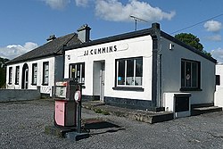
 Disused garage at Curraghboy | |
 Curraghboy Location in Ireland | |
| Coordinates: 53°29′02″N 8°06′36″W | |
| Country | Ireland |
| Province | Connacht |
| County | County Roscommon |
| Time zone | UTC+0 (WET) |
| • Summer (DST) | UTC-1 (IST (WEST)) |
See also
- List of towns and villages in Ireland
References
- "An Currach Buí / Curraghboy". logainm.ie. Irish Placenames Commission. Retrieved 8 March 2020.
- "Whole School Evaluation Report - Curraghboy National School, Curraghboy, Co. Roscommon" (PDF). education.ie. Department of Education. 6 March 2013. Retrieved 8 March 2020.
На других языках
- [en] Curraghboy
[ru] Каррабой
Каррабой[1] (англ. Curraghboy; ирл. An Currach Buí)[2] — деревня в Ирландии, находится в графстве Роскоммон (провинция Коннахт) у трассы R362, примерно в трёх километрах от Рахары.Текст в блоке "Читать" взят с сайта "Википедия" и доступен по лицензии Creative Commons Attribution-ShareAlike; в отдельных случаях могут действовать дополнительные условия.
Другой контент может иметь иную лицензию. Перед использованием материалов сайта WikiSort.org внимательно изучите правила лицензирования конкретных элементов наполнения сайта.
Другой контент может иметь иную лицензию. Перед использованием материалов сайта WikiSort.org внимательно изучите правила лицензирования конкретных элементов наполнения сайта.
2019-2025
WikiSort.org - проект по пересортировке и дополнению контента Википедии
WikiSort.org - проект по пересортировке и дополнению контента Википедии
