world.wikisort.org - Ireland
Dunree (Irish: An Dún Riabhach, meaning 'grey (or streaked) fort')[2] is a townland in north-west Inishowen, in County Donegal, Ireland. Part of the civil parish of Desertegney, the townland has an area of approximately 0.8 square kilometres (0.3 sq mi),[1] and had a population of 33 people as of the 2011 census.[3]
Dunree
An Dún Riabhach | |
|---|---|
Townland | |
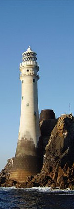
 Dunree Head and lighthouse | |
 Dunree Location in Ireland | |
| Coordinates: 55°11′49″N 7°32′53″W | |
| Country | Ireland |
| Province | Ulster |
| County | County Donegal |
| Area | |
| • Total | 0.87 km2 (0.34 sq mi) |
| Time zone | UTC+0 (WET) |
| • Summer (DST) | UTC-1 (IST (WEST)) |
| Irish Grid Reference | C287390 |
The area, which lies on the shore of Lough Swilly, has a number of tourist attractions such as Dunree Beach, Dunree Lighthouse (which was built in the 1870s),[4] and Fort Dunree. Fort Dunree is a military museum located on Dunree Head about seven miles north of Buncrana. The museum houses a display of military memorabilia and artefacts as well as several large guns from the twentieth century. Next to the fort is Dunree Beach, which tourists and visitors use for parking.[citation needed]
References
- "Dunree Townland, Co. Donegal". townlands.ie. Retrieved 14 January 2021.
- "An Dún Riabhach / Dunree". logainm.ie. Placenames Database of Ireland. Retrieved 14 January 2021.
- "CD154 - Donegal Population by Private Households, Occupied and Vacancy Rate by Townlands, CensusYear and Statistic". data.gov.ie. Central Statistics Office. Retrieved 14 January 2021.
- "Dunree Lighthouse". irishlights.ie. Commissioners of Irish Lights. Retrieved 14 January 2021.
External links
Lighthouses in Ireland | ||
|---|---|---|
Lighthouses are shown in anti-clockwise sequence beginning from the north and proceeding west, south, east, and back to north. | ||
| County Donegal |
|  |
| County Sligo |
| |
| County Mayo |
| |
| County Galway |
| |
| County Clare |
| |
| County Kerry |
| |
| County Cork |
| |
| County Waterford |
| |
| County Wexford |
| |
| County Wicklow |
| |
| County Dublin |
| |
| County Louth |
| |
| County Down |
| |
| County Antrim |
| |
| ||
This article related to the geography of County Donegal, Ireland is a stub. You can help Wikipedia by expanding it. |
Другой контент может иметь иную лицензию. Перед использованием материалов сайта WikiSort.org внимательно изучите правила лицензирования конкретных элементов наполнения сайта.
WikiSort.org - проект по пересортировке и дополнению контента Википедии