Sasaram (English: //(listen))sometimes also spelled as Sahasram, is an ancient historical city and a municipal corporation region in the Rohtas district of the Bihar state in eastern India, with a history that goes to thousands of years. During the prehistoric age, Buddha walked through this way and lived for some days and then travelled to Gaya to be enlightened with verity and wisdom under the Mahabodhi tree, the city is also known as gateway of "Vihar" to visit rest "Bihar" including Gaya, Rajgriha, and Nalanda.
"Sahasram" redirects here. For the 2010 film, see Sahasram (film).
This article has multiple issues. Please help improve it or discuss these issues on the talk page. (Learn how and when to remove these template messages)
This article may require cleanup to meet Wikipedia's quality standards. The specific problem is: Later sections in the article are not properly formatted.(October 2012)
This article needs additional citations for verification. (March 2011)
This article's tone or style may not reflect the encyclopedic tone used on Wikipedia. (October 2020)
This article uses bare URLs, which are uninformative and vulnerable to link rot.(August 2022)
City in Bihar, India
Sasaram
𑂮𑂰𑂮𑂰𑂱𑂩𑂰𑂧
City
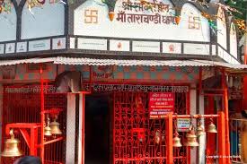
top left to right Maa Tara Chandi temple, Sher Shah Suri's Tomb, Sher Garh Fort, Buddha statue at Sasaram, Sasaram Junction and Kandahar Quila
It has also served as the capital of the Sur dynasty during Shershah Suri ruled over India in 16th Century, and was residence place sub capital of epic monarch Sahstrabahu ( Kartivirya Arjuna's ). The Rohtasgarh fort, one of the world's oldest forts, has served as the capital for several dynasties, Britishers and other rulers, including Shershah Suri and Akbar Governor King Man Singh, as well as the Shashanka and Kharvar empires. The historical fort has been linked to both political and revolutionary activities. It is not only Bihar's, even India's, oldest fort. It was also Shershah Suri's capital palace when he ruled India.
Sasaram and the Kaimur mountain range is a nature's blessed land now a prime hot tourist destination for nature's lovers, enriched by numerous spectacular waterfalls, lakes, rivers and picturesque locations as it is described by Ain-I-Akbari it has over 200 waterfalls emerges during rainy season and few among them are extremely exotic gorgeous to explore.i.e. Dharohar - Karamchat Waterfall, Geetaghat Heaven Holy Waterfall, Panari Ghat/Gaurav Waterfalls, Manjharkund, Dhuvan Kund, Sitakund, Kashish, Mahadev Khoh & Tutla Bhavani Waterfalls are among the most famous. Telhar Kund, Karkat Garh, Mundeshwari Waterfall, Bansi Khoh, Netua Kund, and Chandradhari Waterfalls are also well known in the nearby city in Kaimur Mountain range.
Modern Sasaram city covers the largest sub-metropolitan area of Bihar. It has many famous religious and historical spots to visit such as Shershah tomb, Rohtasgarh fort, Indrapuri Dam, Karamchat Dam Shergarh fort, Kandhar fort, Sacred Tarachandi Shaktipith, Bhaluni dham, Mahadev Khoh, Chaurasan temple, Gupta Dham, Tutla Bhawani temple, Pilot Baba Dham, Godaila Pahad Temple, Anicat Dam, Eco park and the many, the entire district is surrounded by the most scenic mountain beauty of Kaimur range, rivers and productive fields.
Sasaram city is located in the middle of its other sub-towns like Nokha & Kudra which has a large number of agriculture based industries and the city is also emerging as an educational hub.[citation needed] It is situated in the middle of other industrial twin towns like Dehri-on-sone, Dalmianagar, Sonnagar, Amjhor, Nokha and Banjari.
The main posh places of the sub-metropolitan area are Raj Colony, Gauraxni, New Area, Takiya bazar, Tomb Area and Fazalganj commercial zones, Sahu Cinemax - Mall & Railway cricket stadium area. Several malls have been opened along with the best 3-4 star hotels with good medical facilities in the city and is a medical hub of old Shahabad District too.
Sasaram city Region is the administrative headquarters of Rohtas District, Bihar India. It became a district carved out from Shahabad District in 1972. This district headquarter is best known for having the highest literacy rate and highest agricultural & forest cover area of Bihar [citation needed]. Sasaram is also the headquarters of a community development block of the same name, with a total population of 358,283 as of 2011, making it the most populous block in Rohtas district.[2]
It is known for the production of cement, fertilizers, stone chips, and for the quarrying industry and also Sasaram district is popularly known as the "bowl of rice".
Major languages spoken in this region are Bhojpuri, Hindi, English and Urdu; religions include Hinduism, Islam, Buddhism, Christianity, Sikhism, and Jainism.
History
During the Vedic age, Sasaram was a part of the ancient Kashi kingdom. Sasaram name is originated from the Sahastrarama, meaning a thousand groves. Sasaram was once also named Shah Serai (meaning "Place of King") as it is the birthplace of the Afghan king Sher Shah Suri, who ruled over Delhi, much of northern India, what is now Pakistan, and eastern Afghanistan for five years, after defeating the Mughal Emperor Humayun. Many of Sher Shah Suri's governmental practices were adopted by the Mughals and the British Raj including taxation, administration, and the building of a paved road from Kabul to Bengal, also called the Grand Trunk Road.
Sher Shah Suri's 122 feet (37m) red sandstone tomb, built in the Indo-Afghan style stands in the middle of an artificial lake in Sasaram. It borrows heavily from the Lodhi style, and was once covered in blue and yellow glazed tiles indicating an Iranian influence. The massive free standing dome also has an aesthetic aspect of the Buddhist stupa style of the Mauryan period. The tomb of Sher Shah's father Hasan Khan Suri is also at Sasaram, and stands in the middle of a green field at Sherganj, which is known as Sukha Rauza. About a kilometer to the north west of Sher Shah's tomb lies the incomplete and dilapidated tomb of his son and successor, Islam Shah Suri.[3] Sasaram also has a Baulia, a pool used by the emperor's consorts for bathing.
The fort of Sher Shah Suri at Rohtasgarh is in Sasaram. This fort has a history dating back to the 7th century AD. It was built by Raja Harishchandra, known for his truthfulness in the name of his son Rohitashwa. It houses the Churasan temple, Ganesh temple, diwan-e khas, diwan-e-aam, and various other structures dating back to different centuries. The fort also served as the headquarters of Raja Man Singh during his reign as the governor of Bihar and Bengal under the regime of Akbar. The Rohtaas fort in Bihar should not be confused with another fort of the same name, near Jhelum, Punjab, in what is now Pakistan. The Rohtaas fort in Sasaram was also built by Sher Shah Suri, during the period when Humayun was exiled from Hindustan.
There is a temple of Goddess Tarachandi, two miles to the south, and an inscription of Pratap Dhawal on the rock close to the temple of Chandi Devi. Hindus in large number assemble to worship the goddess. Dhuwan Kund, located about 36km (22mi).[citation needed]
There are several monuments near Sasaram, the headquarter of Rohtas district, including Akbarpur, Deomarkandey, Rohtas Garh, Shergarh, TaraChandi, Dhuwan Kund, Gupta Dham, Bhaluni Dham, Historical Gurudwara and Tombs of Chandan Shaheed, Hasan Khan Sur, Sher Shah, Salim Sah and Alawal Khan.
Rohtas, south of Sasaram, is known to have been the residence of one Satyawadi Raja Harischandra, named for his son, Rohitashwa.
Minor Rock Edict of Ashoka
Sasaram is also famous for an inscription by Ashoka (one of the thirteen Minor Rock Edicts), situated in a small cave of Kaimur hill, near Chandan Shaheed.
The edict is located near the top of the terminal spur of the Kimur Range near Sasaram.[4] There is the Minor rock edict #1 only[5] Ashoka famously mentions pre-existing stone pillars in the Edict: "...And where there are stone pillars here in my dominion, there also cause it to be engraved.". 24.94138°N 84.03833°E / 24.94138; 84.03833
The Sasaram Edict (Minor Rock Edict No.1 only).
Devanampriya [speaks] thus.
.................. years since I am a lay-worshipper (upasaka).
But (I had) not been very zealous.
A year and somewhat more (has passed) since ............
And men in Jambudvipa, being during that time unmingled with the gods, have (now) been made (by me) mingled with the gods.
[For] this is the fruit [of zeal].
...........cannot be reached by (persons of) high rank alone, (but) even a lowly (person) is able to attain even the great heaven if he is zealous.
Now, for the following purpose (has) this proclamation (been issued), (that) both the lowly and the exalted may be zealous, and (that) even (my) borderers may know (it), and (that this) zeal may be of long duration,
And this matter will (be made by me to) progress, and will (be made to) progress even considerably; it will (be made to) progress to one and a half, to at least one and a half.
And this proclamation (was issued by me) on tour.
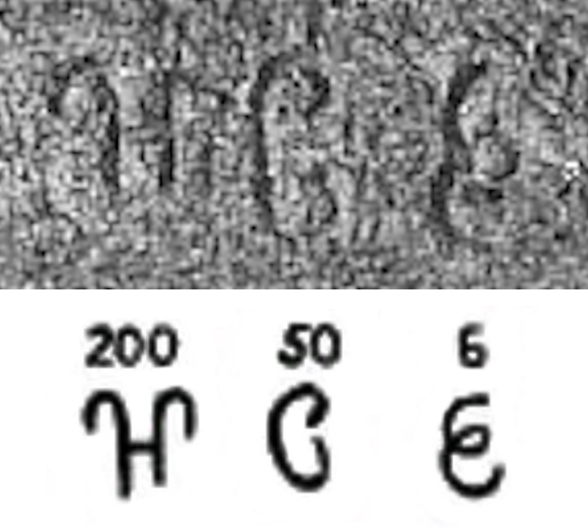
Two hundred and fifty-six nights (had then been) spent on tour, — (in figures) 256.
And cause ye this matter to be engraved on rocks.
And where there are stone pillars here (in my dominions), there also cause (it) to be engraved.
—Sasaram Edict (Translated in Inscriptions of Asoka. New Edition by E. Hultzsch)[6]
The Edict is located on top of the terminal spur of the Kimur range.
The name Jambudīpasi for "India" (Brahmi script) in the Sahasram Minor Rock Edict of Ashoka, circa 250 BCE.[7][8]
This site is included in UNESCO World Heritage Centre – Tentative list.[9]
Tomb of Sher Shah, built in the middle of the town, is one of the noblest specimens of Pathan architecture in India, is an imposing structure of stone, standing in the middle of a fine tank, and was built towards the middle of sixteenth century. Its height from the floor to the apex of the dome is 101 feet (31m) and its total height above the water is over 150 feet (46m) feet. The octagon forming the tomb has an interior diameter of 75 feet (23m) feet and an exterior diameter of 104 feet (32m) feet. The tomb is the second highest in India which attracts tourists. The tomb of Shershah Suri at Sasaram is an imposing structure of stone standing in the middle of a fine tank and rising from a large stone terrace. This terrace rests obliquely on a platform with a flight of steps leading to the water's edge. The upper terrace is enclosed by a battlemented parapet wall with octagonal domed chambers at four corners, two small projecting pillared balconies on each of its four sides and pierced with a doorway in the east forms the only approach to the tomb. In the middle of the upper terrace stands the building of the mausoleum on a low octagonal plinth. The building consists of a very large octagonal chamber surrounded by a wide verandah on al the four sides. Internally, the verandah is covered by a series of 24 small domes, each supported on four arches but as the roof is a pillared cupola adorned by panels of white glazed tiles now much discoloured. The tomb chamber has three lofty arches on each of the eight sides. They rise 22 feet (6.7m) higher than the verandah roof and support the magnificent and lofty dome which is one of the largest domes in India. Surrounding the main dome are eight pillared cupolas on the corners of the octagon of the chamber walls. The interior of the tomb is sufficiently well ventilated and lighted through large windows on the top portion of the walls fitted with stone jalis in varying patterns. The jambs and spandrils of the arch of the mihrab on the western wall were once profusely adorned with verses from the Quran and inscriptions, with glazed tiles of various colours arranged in geometrical patterns and with floral carvings in stone enclosed in enamel borders. Much of this decoration has vanished already. Traces of similar decoration in enamel or glazed tile works are also to be scen on the interior of the dome, the walls and the cupolas on the outside. In a small arched recess above the mihrab on the outside wall is an inscription in two lines recording the completion of the tomb by his son and successor Salim or Islam Shah, some three months after the death of Sher Shah who died in A.H. 952 (A.D.1545). It is second largest dome of India.
The tomb of Hasan Khan Sur, father of Sher Shah is also located in the town. This tomb is also known as Sukha Roza.
As Sasaram is surrounded by hills from two sides, its climate is seasonable. The climate is characterized by relatively high temperatures and evenly distributed precipitation throughout the year. The Köppen Climate Classification sub-type for this climate is "Cfa" (Humid Subtropical Climate).[11]
As of 2020 India census, Sasaram had a population of 351,408 but in urban agglomeration. Males constitute 52% of the population and females 48%. Sasaram has an average literacy rate of 80.26%, higher than the national average of 74%; male literacy is 85%, and female literacy is 75%. In Sasaram, 13% of the population is under 6 years of age.[13]
Religions Sasaram City (2020
)
Hinduism
72.97%
Islam
25.58%
Sikhism
1.25%
Christianity
0.10%
Jainism
0.02%
Buddhism
0.01%
Not Stated
0.25%
Distribution of religions
Sasaram is the 10th most populous city in bihar.
See also: List of cities in Bihar
Governance
The eKiosk (Sahaj Vasudha Kendra, Jamuhar)
SAHAJ Vasudha Kendra, the first "Common Service Centre", or "eKiosk", in Rohtas District was inaugurated in Jamuhar village on 15 August 2008. The centre is currently planning to start a block information Centre, e-district plan, and Sawan Sasaram.
Lok Sabha constituency
Sasaram (Lok Sabha constituency) is one of the 40 Lok Sabha (parliamentary) constituencies in Bihar state in eastern India.
Vidhan Sabha constituency
Sasaram (Vidhan Sabha constituency) is one of 243 legislative assembly of Bihar. It is comes under Sasaram lok sabha constituency.[14]
Economy
The closure of the industries of the Dalmia Group at Dalmianagar resulted in widespread unemployment. Sasaram's economy is mainly driven by agriculture and related industries like rice polishing. The canal irrigation system is also very prominent in this area. Because of the fertile land around the town it is a local trading center for food grains, agricultural products, and agricultural equipment. The region is known as Dhan Ka Katora, meaning "a bowl of food grains". The rice grown near Sasaram is sold in the markets of Kolkata and New Delhi. The only significant industry is rock quarrying.
Transportation
Road
Sasaram is well connected both by road and railways. The NH 19 (old number: NH 2; Grand Trunk Road) passes through the city. The main mode of local transportation are buses operated by both private operators and the state government. The private buses are more frequent and connected to most of the local bazaars. NH 19 connects Delhi in the north-west via Varanasi, Mirzapur, Allahabad, Kanpur and Kolkata in East via Gaya, Dhanbad.
There are also many AC buses available for Sasaram to New Delhi, Patna, Bokaro, Ranchi, Tata.
Sasaram has a big size railway junction. The station belongs to A class category with 8 platforms. The station has to be developed as the world-class which is located at the centre of the city on the Grand Trunk Road. Sasaram's other stations are Shivsagar, kumahu, Nokha, Karwandiya, Pahleja and Dehri on Sone.
Sasaram station is 101 Kilometers away from Pt. Deen Dayal Upadhaya station (less than 1.5 hours) and about 120km (75mi), or two hours journey from Varanasi, and 101km (63mi) from Gaya station. Gaya station is 20km (12mi) away Bodh Gaya, the most sacred place in Buddhism. Trains run from Sasaram to Kolkata, Ara, Ranchi, Patna, New Delhi, and Bikramganj, Bombay.
A direct weekly AC train had been started from Sasaram to Anand Vihar Terminal in July 2011 (22409/22410 - Sasaram - Anand Vihar Garib Rath Express). However, now this AC train runs between Gaya and Anand Vihar Terminal, still stopping at Sasaram Junction.
Airport
Sasaram has also a small and old airport called Suara Airport. A new airport is proposed to be established in near future.[when?][15][16]
Education
Sasaram is the sixth most literate city in Bihar, with Rohtas being the most literate district in Bihar.[17][18]
There are four government colleges, although many students prefer to go to more developed cities for quality education, such as Bangalore, New Delhi, Pune, Patna, Varanasi and Puducherry, for higher education. A new engineering college has been set up in the region.
This Place is also known for preparation of competitive exams at Sasaram Railway junction.[19] According to earlier natives of this city, there was not proper electrification of city around 2007 - 2008 which hampered the studies of students seeking for competitive exams. Indian Railways had 24 hours power supply at Sasaram junction. This led a small group of students to study there at night under electric lights.
St. Jeelani's Public School, Shahjuma, Sasaram[39]
Pragya Niketan Public School, Falzalganj, Sasaram[40]
Villages
Besides the city of Sasaram itself, there are 171 villages in Sasaram block, of which 144 are inhabited and 27 are uninhabited. The total rural population of Sasaram block is 210,875, in 34,336 households.[2]
Village name
Total land area (hectares)
Population (in 2011)
Dhanarhi
75.3
745
Fatehpur
55.1
186
Danwarua
47
0
Patanwan
116.6
454
Mosahebpur
81.4
879
Rasulpur
87.7
804
Bhikhanpura
132
0
Samarodiha
323.3
1,995
Chaukhanda Chitauli
140.4
1,408
Shivpur Chitauli
44.9
1,146
Turki
69.6
2,113
Lodhi
48.6
395
Barawan
60.6
820
Uttimpur Haraha
33
0
Belthua
60.8
487
Banrasia
55.4
2,585
Belarhi
160.3
2,886
Singuhi
108.1
1,653
Patanwan
38
0
Kataprath
27
0
Naugain
82.1
548
Khairi
105.3
437
Khaira
112.6
1,421
Niranjanpur
17
400
Bishunpura
54.7
0
Mahranian
20.6
652
Bhadokhara
186.2
2,988
Belahar
76.4
1,199
Sikaria
1,171.9
4,934
Kota
206.4
2,303
Rajokhar
118.3
0
Ashikpur
37
0
Hetimpur
12
653
Karpurwa
35.7
2,709
Bhatarhi
71.2
839
Beda
69.2
1,852
Kanserwa
72.2
0
Lakhrawan
8.8
0
Mohaddi Ganj
44.1
3,240
Dhanpurwa
20.4
1,340
Dilia
33.8
0
Mirzapur
3
0
Udhopur
43.7
136
Madaini
254.9
815
Sumbha
70.8
745
Ahrawan
128.7
705
Misripur
56.7
532
Madauria
50
161
Dhunan
67.2
708
Karam Dihri
146.9
1,371
Tetari
91.1
709
Haripur
24.7
53
Kuraich
35
1,598
Takia
8.7
5
Muradabad Kalan
144.8
4,291
Muradabad Khurd
154.2
2,310
Uchitpur
174
3,794
Nekara
140.8
2,056
Neae
131.1
1,644
Baradih
121.8
3,202
Nimia
102.4
792
Kothara
156.2
929
Bhagwanpur
93.9
626
Semra
80.1
617
Bajila
104.8
1,112
Gamharia
67.2
707
Mokar
372.7
3,409
Agrer
263.8
3,774
Rakasia
124.2
1,867
Jhalkhoria
50.2
779
Akasi
391.8
4,145
Kunrwa
106.4
1,064
Pipri
137.2
945
Katdehri
199.8
1,137
Gotpa
228.3
1,961
Maudiha
85.4
1,010
Kharaunia
101.6
756
Sumbha
178.4
830
Garara
206.8
2,461
Rudana
106.8
1,020
Rajekarma
49.4
0
Babhanpurwa
46.1
465
Gobina
89
1,039
Karup
117.3
1,636
Dilia
62.3
856
Lok Dehri
62.8
686
Inaihia
57.9
546
Bhainsahi
172.8
1,041
Bishunpura
76.1
696
Bhajea
103
0
Jaipur
139.2
1,359
Nirmalpur
38
302
Nirmalpur
72.8
0
Rampur
287
2,895
Semra
148
186
Bahrar
143
1,355
Khanra
81.4
588
Patia
118
1,476
Dumaria
86
1,301
Kaupa Dih
89
624
Bajinathpur
39
0
Gansa Dih
170
2,695
Chhotka Mor
76.4
1,191
Barka Mor
201
1,439
Pasia Dih
35
433
Bara Dih
121
418
Basuhara
89
683
Nahauna
288
3,208
Bhorman
64
429
Koiria Dih
36
0
Paisara
107
890
Tiwari Dih
36
314
Bhurekunria
18
341
Belwa
101
675
Khurhunu
178
1,684
Jigina
178
754
Tendua
101
1,150
Bararhi
134
1,507
Shahpur
90
1,099
Bishunpur
62
858
Chaubea
57
584
Bisrampur
138
1,907
Karwania
131
3,446
Basa
101.1
2,683
Jagdaun Dih
48.6
400
Durgapur
87.9
1,057
Amra, Sasaram
205.6
4,944
Amri, Sasaram
197.4
5,527
Dawanpur
238.4
2,544
Karma
136
538
Nima
68.4
580
Ghatmapur
75.6
821
Basantpur
164.8
1,084
Admapur
213.7
1,746
Gaeghat
209
1,481
Fazilpur
123
334
Gajdwahi
327.8
2,678
Kanchanpur
480
2,865
Kurdaun
322
711
Dhankarha
113.3
2,696
Lerua
100.8
2,984
Mednipur
146.9
2,084
Dhaudanr
1,125.4
5,816
Mahua Dihra
2,713
0
Jawarh
662.1
0
Palangarh
580.3
0
Kauria
85
0
Tendua
202.7
702
Murhi
120.1
2,071
Karserua
269.1
2,309
Gharbair
269.9
1,344
Barui
265
1,238
Songawan
288.6
2,188
Mundi Sarae
121
0
Molawan
273.1
2,638
Sakas
156.6
1,014
Dhanpurwa
45.4
298
Kusri
127.1
1,417
Dubaulia
25.9
0
Khairi
35.2
72
Babura
45
707
Khaira
115
831
Bichhia
25
0
Darigawan
362
5,964
Agni
133
626
Jamahath
135
680
Karaunia
316
0
Tikra
195
0
Ramgaraha
1,168
0
Goria
4,072
316
Notable people
Sher Shah Suri: Emperor of India, conquered Mughal Empire defeating 2nd Mughal emperor Humayun.
Chhedi Paswan, Member Of Indian Parliament, Ex- MLA
Babu Jagjivan Ram: former Deputy Prime Minister of India[41][circular reference]
Meira Kumar: former Speaker of the Lok Sabha of India[42][circular reference]
Другой контент может иметь иную лицензию. Перед использованием материалов сайта WikiSort.org внимательно изучите правила лицензирования конкретных элементов наполнения сайта.
2019-2026 WikiSort.org - проект по пересортировке и дополнению контента Википедии


 The Edict is located on top of the terminal spur of the Kimur range.
![The name Jambudīpasi for India (Brahmi script) in the Sahasram Minor Rock Edict of Ashoka, circa 250 BCE.[7][8]](//upload.wikimedia.org/wikipedia/commons/thumb/0/08/Jambudiipasi.jpg/120px-Jambudiipasi.jpg) The name Jambudīpasi for "India" (Brahmi script) in the Sahasram Minor Rock Edict of Ashoka, circa 250 BCE.[7][8]
The name Jambudīpasi for "India" (Brahmi script) in the Sahasram Minor Rock Edict of Ashoka, circa 250 BCE.[7][8]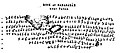 Transcription of the Edict.
 The number "256" towards the end of the Edict.
![The name Jambudīpasi for India (Brahmi script) in the Sahasram Minor Rock Edict of Ashoka, circa 250 BCE.[7][8]](http://upload.wikimedia.org/wikipedia/commons/0/08/Jambudiipasi.jpg)


 Sasaram travel guide from Wikivoyage