world.wikisort.org - India
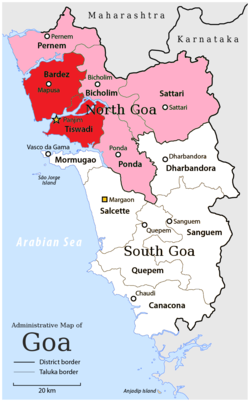
North Goa district is one of the two districts that constitutes the state of Goa, India. The district has an area of 1,736 square kilometres (670 square miles), and is bounded by Kolhapur and Sindhudurg districts of Maharashtra state to the north and by Belgavi district of Karnataka to the east, by South Goa district to the south, and by the Arabian Sea to the west.
North Goa district
उत्तर गोंय जिल्लो | |
|---|---|
District of Goa | |
 Location of North Goa within Goa Red: Velhas Conquistas regions Pink: Novas Conquistas regions | |
| Country | |
| State | |
| Headquarters | Panaji |
| Taluka | |
| Government | |
| • District collector | Mamu Hage, I.A.S.[1] |
| • Superintendent of Police | Shobit Saksena, IPS |
| • Lok Sabha constituencies | North Goa |
| • Member of Parliament, Lok Sabha | Shripad Naik (BJP) |
| • Zilla Parishad, Chairperson | Kartik Kudnekar |
| Area | |
| • Total | 1,736 km2 (670 sq mi) |
| • Rank | 2nd |
| Highest elevation (Sonsogor) | 1,166 m (3,825 ft) |
| Population (2011) | |
| • Total | 818,008 |
| • Rank | 1st |
| • Density | 470/km2 (1,200/sq mi) |
| • Urban | 60.28%[2] |
| Demography | |
| • Language [3] | Konkani |
| • Religion (2011)[4] |
|
| Human Development | |
| • Literacy | 89.57 |
| • Sex ratio | 963 |
| Time zone | UTC+05:30 (IST) |
| PIN | 4030xx, 4031xx, 4032xx, 4034xx, 4035xx (North Goa)[5] |
| Telephone | +91 0832 |
| Vehicle registration | GA-01 |
| Climate | Am (Köppen) |
| Largest city | Panaji (21.01 km2 (8.11 sq mi)) |
| Largest city (by population) | Mapusa |
| Average annual precipitation | 320 cm (3,200 mm) (June–September) |
| Website | northgoa |
Historical background
This section does not cite any sources. (January 2021) |
At the advent of the Portuguese in AD 1510, all of today's northern territories (Ilhas, Bardez, Pernem, Bicholim, Antruz, and Sattari) were part of the Bijapur Sultanate. Ilhas and Bardez were annexed by Portugal after their successful conquest and the region is now called Velhas Conquistas (Old Conquests). After the fall of the Deccan sultanates and rise of the Marathas in the late 1600s, the remaining region eventually fell under the control of the Maratha Kingdom of Sawantwadi until AD 1783. These territories were seen as safe haven for the Hindus, Muslims and new-Christians who fled the Portuguese Inquisition taking place in Goa. These territories were acquired by Portuguese as part of Novas Conquistas (New Conquest) in the late 18th centuries. They remained with the Portuguese until 1961 when they were annexed by India.
Goa and two other former Portuguese enclaves became the union territory of Goa, Daman, and Diu, and Goa was organized into a single district in 1965. On 30 May 1987, Goa attained statehood (while Daman and Diu remained a union territory), and Goa was reorganized into two districts, North Goa and South Goa.
Portuguese in Goa (1510–1961)
Advent of Portuguese (1498)
Lured by the thrill of discovery and goaded by the prospect of seeking Christians and spices Portugal embarked on perilous voyages to the Orient which culminated in Bartholomew Dias’ trip around the Cape of Good Hope. This spectacular breakthrough opened new vistas. A decade later Vasco Da Gama set off eastwards and in AD 1498 landed in Calicut and broke the Arab monopoly of trade.
Estado Da India (1510)
Fired with the dream of establishing an Eastern Empire for Portugal, Afonso De Albuquerque, Governor-General of Goa, set to acquire strategic centers also the trade route. At the invitation of the Admiral of the Vijayanagar's fleet, he occupied Goa with little initial opposition. Though temporarily routed, he triumphantly regained possession of the city on 25 November 1510, and kneeling in the public square he dedicated Goa to St. Catherine whose feast was on that day.
In 1530 Goa became the capital of the Portuguese Empire in the East and mistress of the sea from the Cape of Good Hope to the China Sea.
Saint Francis Xavier (1542–1552)
The arrival in AD 1542 of a young Spanish nobleman turned Jesuit, with a brilliant background of academic learning, created an impact that was tremendous. His compassion for the weak and the downtrodden, his dynamic zeal and his innate holiness edified many. Two years after his death in AD 1552, the incorrupt body of the saint was enshrined in Goa. It continued to attract pilgrims from all over the world even to this day.
India's first printing press (1556)
The first printing press of moveable types in the whole of India printed Doutrina Christa written by Francis Xavier & Garcia de Orta called Colloquios Dos Simples Drogos Medicinais and an early work of the poet Luis De Camoes entitled Os Disparates Da India.
Indian Incersions (1946–1961)
Jai Hind Movement (1946)
To intensify the flickering torch of freedom, the Indian Socialist leader, Dr. Ram Manohar Lohia, courted arrest on 18 June 1946 by defiantly addressing a mammoth meeting in Goa.
In August 1946, at Londa on the border, a mass meeting of Goan nationalist workers charted out a plan of non-violent action. To express the peoples's longing for freedom, satyagrahas were launched until the year ended in different parts of the Portuguese enclaves and resulted in 1500 Goans being imprisoned and the ring leaders deported.
Goa Action Committee (1953)
After the French withdrawal from India, a futile attempt was made by the Government of India to negotiate with Portugal for a peaceful transfer of its possession to the Indian Union. Consequently, the Goa Action Committee was formed in Bombay to awaken sympathy for its cause within the country and abroad.
Operation Vijaya (1961)
In 1958 all parties amalgamated under the banner of Goan Political Convention presided over by Professor Aloysius Soares.
In a carefully planned action by Armed forces, the Government of India entered Goa. Scant resistance was offered and in December 1961 with hardly any bloodshed, Goa was liberated from the Portuguese to remove the last vestiges of foreign domination in India.
Geography
Its geographical position is marked by 15° 48′ 00″ N to 14° 53′ 54″ N latitudes and 73° E to 75° E longitudes
Climate
| Climate data for Panaji (1971–1990) | |||||||||||||
|---|---|---|---|---|---|---|---|---|---|---|---|---|---|
| Month | Jan | Feb | Mar | Apr | May | Jun | Jul | Aug | Sep | Oct | Nov | Dec | Year |
| Record high °C (°F) | 36.6 (97.9) |
39.2 (102.6) |
39.0 (102.2) |
39.8 (103.6) |
38.6 (101.5) |
35.9 (96.6) |
32.3 (90.1) |
34.0 (93.2) |
33.2 (91.8) |
37.2 (99.0) |
37.2 (99.0) |
36.6 (97.9) |
39.8 (103.6) |
| Average high °C (°F) | 32.0 (89.6) |
31.7 (89.1) |
32.2 (90.0) |
33.1 (91.6) |
33.4 (92.1) |
30.3 (86.5) |
29.1 (84.4) |
28.7 (83.7) |
29.8 (85.6) |
31.8 (89.2) |
32.9 (91.2) |
32.7 (90.9) |
31.5 (88.7) |
| Daily mean °C (°F) | 26.0 (78.8) |
26.3 (79.3) |
27.7 (81.9) |
29.3 (84.7) |
30.0 (86.0) |
27.6 (81.7) |
26.7 (80.1) |
26.4 (79.5) |
26.9 (80.4) |
27.9 (82.2) |
27.6 (81.7) |
26.9 (80.4) |
27.4 (81.3) |
| Average low °C (°F) | 19.9 (67.8) |
20.7 (69.3) |
23.2 (73.8) |
25.5 (77.9) |
26.5 (79.7) |
24.8 (76.6) |
24.3 (75.7) |
24.0 (75.2) |
24.0 (75.2) |
23.9 (75.0) |
22.2 (72.0) |
21.0 (69.8) |
23.3 (73.9) |
| Record low °C (°F) | 14.4 (57.9) |
13.3 (55.9) |
17.5 (63.5) |
19.4 (66.9) |
20.9 (69.6) |
20.9 (69.6) |
20.5 (68.9) |
21.7 (71.1) |
21.0 (69.8) |
20.0 (68.0) |
15.3 (59.5) |
15.7 (60.3) |
13.3 (55.9) |
| Average precipitation mm (inches) | 0 (0) |
0 (0) |
1 (0.0) |
5 (0.2) |
56 (2.2) |
861 (33.9) |
853 (33.6) |
622 (24.5) |
237 (9.3) |
111 (4.4) |
35 (1.4) |
2 (0.1) |
2,813 (110.7) |
| Average rainy days (≥ 1.0 mm) | 0.0 | 0.1 | 0.1 | 0.6 | 3.8 | 24.0 | 28.2 | 27.2 | 14.9 | 6.6 | 3.5 | 0.3 | 109.3 |
| Average relative humidity (%) | 67 | 69 | 71 | 71 | 71 | 85 | 88 | 89 | 86 | 80 | 70 | 64 | 76 |
| Mean monthly sunshine hours | 311.8 | 290.2 | 291.0 | 289.0 | 296.5 | 125.1 | 105.7 | 122.1 | 177.1 | 247.7 | 272.6 | 299.3 | 2,828.1 |
| Source 1: NOAA[6] | |||||||||||||
| Source 2: India Meteorological Department (record high and low up to 2010)[7] | |||||||||||||
Politics
| No. | Constituency | Name | Party | Alliance | Remarks | ||
|---|---|---|---|---|---|---|---|
| 1 | Mandrem | Jit Arolkar | Maharashtrawadi Gomantak Party | NDA | |||
| 2 | Pernem | Pravin Arlekar | Bharatiya Janata Party | NDA | |||
| 3 | Bicholim | Chandrakant Shetye | Independent | NDA | |||
| 4 | Tivim | Nilkanth Halarnkar | Bharatiya Janata Party | NDA | Cabinet Minister | ||
| 5 | Mapusa | Joshua D'Souza | Bharatiya Janata Party | NDA | |||
| 6 | Siolim | Delilah Lobo | Indian National Congress | UPA | Elected on Congress ticket On 14 Sep 2022, left Congress and joined BJP[8] | ||
| Bharatiya Janata Party | NDA | ||||||
| 7 | Saligao | Kedar Naik | Indian National Congress | UPA | Elected on Congress ticket On 14 Sep 2022, left Congress and joined BJP[8] | ||
| Bharatiya Janata Party | NDA | ||||||
| 8 | Calangute | Michael Lobo | Indian National Congress | UPA | Elected on Congress ticket On 14 Sep 2022, left Congress and joined BJP[8] | ||
| Bharatiya Janata Party | NDA | ||||||
| 9 | Porvorim | Rohan Khaunte | Bharatiya Janata Party | NDA | Cabinet Minister | ||
| 10 | Aldona | Carlos Alvares Ferreira | Indian National Congress | UPA | |||
| 11 | Panaji | Atanasio Monserrate | Bharatiya Janata Party | NDA | Cabinet Minister | ||
| 12 | Taleigao | Jennifer Monserrate | Bharatiya Janata Party | NDA | |||
| 13 | St. Cruz | Rodolfo Louis Fernandes | Indian National Congress | UPA | Elected on Congress ticket On 14 Sep 2022, left Congress and joined BJP[8] | ||
| Bharatiya Janata Party | NDA | ||||||
| 14 | St. Andre | Viresh Borkar | Revolutionary Goans Party | ||||
| 15 | Cumbarjua | Rajesh Faldessai | Indian National Congress | UPA | Elected on Congress ticket On 14 Sep 2022, left Congress and joined BJP[8] | ||
| Bharatiya Janata Party | NDA | ||||||
| 16 | Maem | Premendra Shet | Bharatiya Janata Party | NDA | |||
| 17 | Sanquelim | Pramod Sawant | Bharatiya Janata Party | NDA | Chief Minister | ||
| 18 | Poriem | Deviya Rane | Bharatiya Janata Party | NDA | |||
| 19 | Valpoi | Vishwajit Pratapsingh Rane | Bharatiya Janata Party | NDA | Cabinet Minister | ||
| 20 | Priol | Govind Gaude | Bharatiya Janata Party | NDA | Cabinet Minister | ||
| 21 | Ponda | Ravi Naik | Bharatiya Janata Party | NDA | Cabinet Minister | ||
| 22 | Siroda | Subhash Shirodkar | Bharatiya Janata Party | NDA | Cabinet Minister | ||
| 23 | Marcaim | Sudin Dhavalikar | Maharashtrawadi Gomantak Party | NDA | Cabinet Minister | ||
Administration
The administrative headquarters of the district is Panaji, which is also the capital of the state of Goa. The district forms part of a greater region called the Konkan. Ms Mamu Hage, IAS, is the District Collector.[1]
The district is divided into three subdivisions — Panaji, Mapusa, and Bicholim; and five talukas —Tiswadi (Panaji), Bardez (Mapusa), Pernem, Bicholim, and Sattari (Valpoi).
Ponda taluka moved from North Goa to South Goa in January 2015.
Demographics
| Year | Pop. | ±% p.a. |
|---|---|---|
| 1900 | 294,074 | — |
| 1910 | 306,323 | +0.41% |
| 1920 | 288,039 | −0.61% |
| 1930 | 313,614 | +0.85% |
| 1940 | 336,628 | +0.71% |
| 1950 | 330,874 | −0.17% |
| 1960 | 349,667 | +0.55% |
| 1971 | 458,312 | +2.49% |
| 1981 | 568,021 | +2.17% |
| 1991 | 664,804 | +1.59% |
| 2001 | 758,573 | +1.33% |
| 2011 | 818,008 | +0.76% |
| source:[9] | ||
Population
According to the 2011 census North Goa has a population of 8,18,008[10] which is roughly equal to the nation of Comoros[11] or the US state of South Dakota.[12] This gives it a ranking of 480th in India (out of a total of 640). The district has a population density of 471 inhabitants per square kilometre (1,220/sq mi). Its population growth rate over the decade 2001–2011 was 7.8%. North Goa has a sex ratio of 959 females for every 1000 males, and a literacy rate of 88.85%.[10]
Language
Languages North Goa (2011)
Konkani is the mother tongue of a majority of the people living in North Goa district. Portuguese is also spoken and understood by a small number of people.
At the time of the 2011 Census of India, 65.86% of the population in the district spoke Konkani, 14.36% Marathi, 8.65% Hindi, 3.62% Kannada, 2.39% Urdu, 0.92 Portuguese, 0.86 English, 0.80 Malayalam, 0.68% Telugu, 0.47% Tamil, 0.46% Gujarati and 0.43% Bengali as their first language.[3]
Religion
Hinduism (76%) is followed by the majority of population of North Goa. Christians (16%) form significant minority.[4]
Tourism

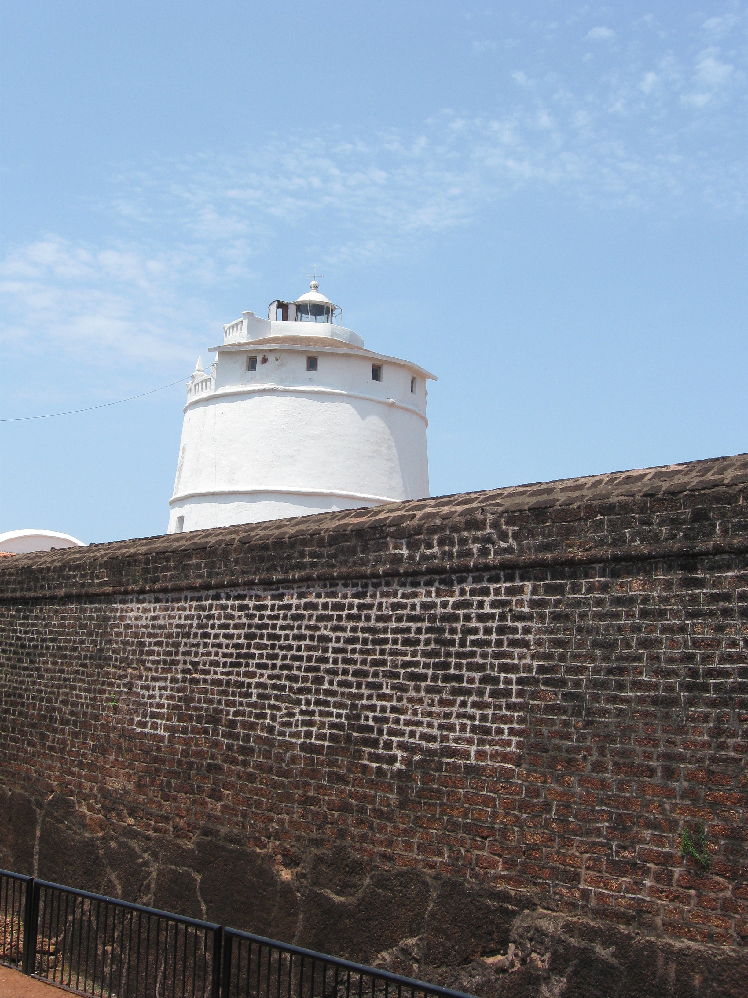
North Goa is known for its beaches, which include Anjuna Beach, Candolim Beach, Mandrem Beach, Calangute Beach, Morjim Beach, and Arambol Beach.[13] Other tourist sites include Fort Aguada, The church of Mae De Deus and the temple of Boghdeshwara.[14] Chorao, Divar Island are islands of North Goa which are accessible via a ferry crossing.[15]
References
- https://www.goa.gov.in/wp-content/uploads/2022/03/Order-Personnel-Department.pdf [bare URL PDF]
- "North Goa District Population Census 2011–2019, Goa literacy sex ratio and density". Indian Census 2011. Retrieved 31 December 2019.
- "C-16 Population By Mother Tongue - Goa". censusindia.gov.in. Retrieved 4 October 2019.
- "C-1 Population By Religious Community". census.gov.in. Retrieved 15 September 2020.
- North Goa
- "Goa (Panjim) Climate Normals 1971-1990". National Oceanic and Atmospheric Administration. Retrieved 15 April 2015.
- "Ever recorded Maximum and minimum temperatures up to 2010" (PDF). India Meteorological Department. Archived from the original (PDF) on 16 March 2014. Retrieved 15 April 2015.
- "8 Goa Congress MLAs defect to BJP". The Indian Express. 14 September 2022. Retrieved 14 September 2022.
- "Census of India Website : Office of the Registrar General & Census Commissioner, India". www.censusindia.gov.in. Retrieved 31 December 2019.
- "District Census 2011". Census2011.co.in. 2011. Retrieved 30 September 2011.
- US Directorate of Intelligence. "Country Comparison:Population". Archived from the original on 13 June 2007. Retrieved 1 October 2011.
Comoros 794,683 July 2011 est.
- "2010 Resident Population Data". United States Census Bureau. Archived from the original on 25 December 2010. Retrieved 30 September 2011.
South Dakota 814,180
- Phillipose, Susan (29 December 2019). "How to spend a day near Morjim Beach in North Goa". OnManorama. Retrieved 31 December 2019.
- "The Top 10 Things to Do in North Goa District 2017 - Must-See Attractions in North Goa District, India | TripAdvisor". www.tripadvisor.in. Retrieved 25 November 2017.
- Menezes, Vivek (10 November 2017). "Travel Special: Ilhas de Goa". Livemint. Retrieved 30 March 2020.
External links
- North Goa District Website Archived 19 December 2011 at the Wayback Machine
Places adjacent to North Goa district | ||||||||||||||||
|---|---|---|---|---|---|---|---|---|---|---|---|---|---|---|---|---|
| ||||||||||||||||
| History |
| ||||||
|---|---|---|---|---|---|---|---|
| Government |
| ||||||
| Geography |
| ||||||
| Districts |
| ||||||
| Talukas | |||||||
| Cities |
| ||||||
| Heritage sites |
| ||||||
| Wildlife sanctuaries |
| ||||||
| Education |
| ||||||
| Science |
| ||||||
| Culture |
| ||||||
| Sports |
| ||||||
| Transport |
| ||||||
| |||||||
На других языках
[de] North Goa
North Goa ist einer der zwei Distrikte im indischen Bundesstaat Goa. Die Fläche beträgt 1.736 km². Der Distrikt grenzt an den Distrikt Sindhudurg im Bundesstaat Maharashtra im Norden, an den Distrikt Belagavi in Karnataka im Osten, an den Distrikt South Goa im Süden und an das Arabische Meer im Westen. Verwaltungssitz ist die Stadt Panaji.- [en] North Goa district
[ru] Северный Гоа
Се́верный Го́а (порт. Goa Norte, англ. North Goa) — округ в индийском штате Гоа. Образован 30 мая 1987 года. Административный центр — город Панаджи. Площадь округа — 1736 км². По данным всеиндийской переписи 2001 года население округа составляло 758 573 человека. Уровень грамотности взрослого населения составлял 83,5 %, что значительно выше среднеиндийского уровня (59,5 %). Доля городского населения составляла 45,1 %.Другой контент может иметь иную лицензию. Перед использованием материалов сайта WikiSort.org внимательно изучите правила лицензирования конкретных элементов наполнения сайта.
WikiSort.org - проект по пересортировке и дополнению контента Википедии