world.wikisort.org - India
Nehru Park is located on the banks of the Damodar River at Burnpur, a neighbourhood in Asansol in the Indian state of West Bengal.
Nehru Park | |
|---|---|
Park | |
 A cosy nook in the park | |
 Nehru Park Location in West Bengal, India  Nehru Park Nehru Park (India) | |
| Coordinates: 23.634°N 86.947°E | |
| Country | |
| State | West Bengal |
| District | Paschim Bardhaman |
| Elevation | 75 m (246 ft) |
| Languages | |
| • Official | Bengali, English |
| Time zone | UTC+5:30 (IST) |
| Vehicle registration | WB |
| Nearest city | Asansol |
| Location | North bank of Damodar River |
| Precipitation | 1,300 millimetres (51 in) |
| Avg. summer temperature | 40 °C (104 °F) |
| Avg. winter temperature | 25 °C (77 °F) |
Name
The park was planned by F. W. A. Lahmeyer, general manager of the IISCO Steel Plant. Although officially named Riverside Park, it was nicknamed Lahmeyer Park. In 1989, the 100-year anniversary of the birth of India’s first Prime Minister, Jawaharlal Nehru, the park was renamed Nehru Park.[1] A cast iron statue of Nehru, cast at Kulti Works, then part of IISCO, was installed in the park.[citation needed]
References
- Srinivasan, N.R., History of The Indian Iron and Steel Company, 1983, p. 71
Images
Wikimedia Commons has media related to Nehru Park, Burnpur.
 Statue of Jawaharlal Nehru, near the park entrance gate
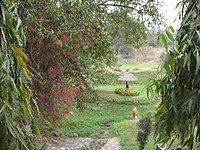 A section of the park
 Lake with boating facilities in the park
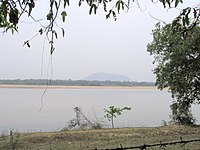 Biharinath, across the Damodar River, as seen from the park


Текст в блоке "Читать" взят с сайта "Википедия" и доступен по лицензии Creative Commons Attribution-ShareAlike; в отдельных случаях могут действовать дополнительные условия.
Другой контент может иметь иную лицензию. Перед использованием материалов сайта WikiSort.org внимательно изучите правила лицензирования конкретных элементов наполнения сайта.
Другой контент может иметь иную лицензию. Перед использованием материалов сайта WikiSort.org внимательно изучите правила лицензирования конкретных элементов наполнения сайта.
2019-2026
WikiSort.org - проект по пересортировке и дополнению контента Википедии
WikiSort.org - проект по пересортировке и дополнению контента Википедии