world.wikisort.org - India
Mayiladuthurai (formerly known as Mayavaram or Mayuram) is a town and district headquarter of Mayiladuthurai district in Tamil Nadu, India. The town is located at a distance of 281 km (175 mi) from the state capital, Chennai.
Mayiladuthurai
Mayavaram | |
|---|---|
Town | |
 Victory Clock Tower at Mayiladuthurai | |
 Mayiladuthurai Mayiladuthurai, Tamil Nadu | |
| Coordinates: 11.101800°N 79.652600°E | |
| Country | |
| State | Tamil Nadu |
| District | Mayiladuthurai district |
| Chola Nadu | Cauvery Delta |
| Government | |
| • Type | Selection grade town panchayat |
| • Body | Mayiladuthurai Municipality |
| • chairman | N Selvaraj |
| Area | |
| • Total | 11.27 km2 (4.35 sq mi) |
| Elevation | 38 m (125 ft) |
| Population (2011) | |
| • Total | 85,632 |
| • Density | 7,600/km2 (20,000/sq mi) |
| Languages | |
| • Official | Tamil |
| Time zone | UTC+5:30 (IST) |
| PIN | 609001 |
| Telephone code | 91 4364 |
| Vehicle registration | TN-82 |
Mayiladuthurai was ruled by Medieval Cholas and subsequently ruled by various dynasties, including the Vijayanagar Empire, Thanjavur Nayaks, Thanjavur Marathas and the British Empire. Mayiladuthurai was a part of the erstwhile Tanjore district until India's independence in 1947 and Thanjavur district until 1991 and subsequently a part of the newly formed Nagapattinam district. The town is known for agriculture, and weaving. As Mayiladuthurai is situated in East Coast, fishing plays an vital role on generating it's revenue.
Mayiladuthurai is administered by a town panchayat established in 1866. As of 2008, the panchayat covered an area of 11.27 km2 (4.35 sq mi). Mayiladuthurai comes under the Mayiladuthurai assembly constituency which elects a member to the Tamil Nadu Legislative Assembly once every five years and it is a part of the Mayiladuthurai constituency which elects its Member of Parliament (MP) once in five years. It is well connected by road and rail transport. Mayiladuthurai serves as an important junction in main line connecting Chennai with Trichy. Roadways and Railways are the major mode of transportation to the town. The nearest airport, Pondicherry Airport, is located 116 km (72 mi) from the town.
Mayiladuthurai was carved out of Nagapattinam district and inaugurated as the 38th district of Tamil Nadu on December 28, 2020.[1]
Etymology
Mayiladuthurai is derived from the word Mayil (peacock). Mayuranathaswami Temple dedicated to the Amman is one of the most important Hindu temples in the town. There is a statue depicting goddess Amman in a peahen form worshipping lingam, an iconic symbol of Shiva.[2]
History
Mayiladuthurai is of significant antiquity, its oldest extant temples dating to the time of the Medieval Cholas. The region, however, is known to have been inhabited since the 3rd millennium BC. Sherds of megalithic black and red ware have been found at Akkur, 14 km (8.7 mi) to the east of Mayiladuthurai.[3] In 2006, artifacts with Indus Valley signs dated between 2000 and 1500 BC were found at the nearby village of Sembiyankandiyur.[4][5] There have been references to Mayiladuthurai in the works of the 7th century Saivite saint Sambandar.[6] The Thanjavur Nayak king Raghunatha Nayak constructed mandapams in Mayiladuthurai.[7] During the 17th and 18th centuries AD, Mayiladuthurai was ruled by the Thanjavur Marathas who invited Brahmins from the Telugu, Kannada and Maratha countries to settle in the region and gave large extents of land to them.[8] In 1799, Mayiladuthurai, was ceded to the British East India Company, along with the rest of the Thanjavur Maratha kingdom, by the Thanjavur Maratha ruler Serfoji II.[9] Mayiladuthurai prospered under British rule emerging as an important town in Tanjore district. Carnatic musicians Madurai Mani Iyer and Gopalakrishna Bharathi and Samuel Vedanayagam Pillai, who wrote the first Tamil novel Prathapa Mudaliar Charithram were connected with Mayiladuthurai while Tamil writer Kalki Krishnamurthy, M.S.Udhaya Moorthy studied at the Municipal High School in Mayiladuthurai.[10] According to local folklore, Mayiladuthurai was associated with Hindu holy men called "Siddhars".[10] To this day, a neighbourhood of Mayiladuthurai is called Siddharkaadu.[10] When the Tanjore district was trifurcated in 1991, Mayiladuthurai was transferred to the newly formed Nagapattinam district.
Mayiladuthurai was inaugurated as the 38th district of Tamil Nadu on December 28, 2020. The district was carved out of the existing Nagapattinam district and inaugurated by the Tamil Nadu Chief Minister K Palaniswami. The declaration was made earlier on March 24, 2020.[11][12]
Geography and climate

Mayliladuthurai is situated at a distance of 281 kilometres (175 mi) from Chennai and 122 kilometres (76 mi) from Tiruchirappalli.[13] The town is located at 11.10°N 79.65°E.[14] Situated at a distance of 24 kilometres (15 mi) from the Bay of Bengal coast, the town is situated at an altitude of barely 10 metres (33 ft) above mean sea level.[13] The Kaveri River runs through the town bisecting it into Uttara Mayuram and Mayuram proper. Most of the town lies to the south of the river and the Mayuranathaswami Temple lies a mile to its south. The famous Parimala Renganathar Temple is situated at Tiruindalur, which lies North of Cauvery river. There is a bathing ghat on the Cauvery river. Agriculture is the most widely practised occupation.[citation needed]
The climate of Mayiladuthurai is generally Tropical which features fairly hot temperatures over the year except during monsoon seasons.The average maximum temperature is 39.4 degrees Celsius while the average minimum temperature is 32.8 degrees Celsius.[13] The average annual rainfall is 1,125 mm.[13]
Administration and politics
| Municipality Officials | |
|---|---|
| Chairman | N.Selvaraj[15] |
| Commissioner | K. Parthiban[16] |
| Vice Chairman | N. Selvaraj[17] |
| Elected Members | |
| Member of Legislative Assembly | S.Rajakumar[18] |
| Member of Parliament | S.Ramalingam[19] |
It is the headquarters of the newly formed Mayiladuthurai district. The town of Mayiladuthurai is administered by a municipal council which was created in 1866 as per the Town Improvements Act 1865. The council initially had eleven members.[20] This was increased to 18 in 1883 and currently stands at 36.[20][21]
As of 2008, the municipality covered an area of 11.27 km2 (4.35 sq mi) and had a total of 36 members. The functions of the municipality is devolved into six departments: General, Engineering, Revenue, Public Health, Town planning and the Computer Wing. All these departments are under the control of a Municipal Commissioner who is the supreme executive head.[22] The legislative powers are vested in a body of 36 members, one each from the 36 wards.[23] The legislative body is headed by an elected Chairperson assisted by a Deputy Chairperson.[24] There are a total of four revenue villages with Mayiladuthurai - Thiruvilandur, Dharmapuram, Nanchilnadu and Kornad.[25] The municipality has allocated a budget of ₹2,183,350,000 for the year 2010–11.[26]
Mayiladuthurai is represented in the Tamil Nadu Legislative Assembly by the Mayiladuthurai state assembly constituency seat.[27]
Mayiladuthurai is a part of the Mayiladuthurai (Lok Sabha constituency).[28][29] The current Member of Parliament from the constituency is S. Ramalingam of the Dravida Munnetra Kazhagam party.
Utility Services
Potable water is provided by the municipality. Mayiladuthurai's main source of water in the Kollidam River.[30] A total of 7.50 MLD are pumped out every day from five water tanks located in various parts of the town.[30] About 104 metric tonnes of solid waste is generated everyday, while 85 metric tonnes are collected from the town every day by door-to-door collection and subsequently the source segregation and dumping is carried out by the sanitary department of the municipality.[31] There is limited underground drainage system in the town and the major sewerage system for disposal of sullage is through septic tanks, open drains and public conveniences.[32] The municipality maintains a total of 39 km (24 mi) of surfaced storm water drains and 4 km (2.5 mi) kutcha drains in Mayiladuthurai.[32][33] There are five government hospitals that include a maternity and a veterinary hospital and seventeen private hospitals and clinics that take care of the health care needs of the citizens.[34] There are a total of 3,262 street lamps in Mayiladuthurai: 2 high mast lamps, 2 mini high mast lamps, 624 sodium lamps, 2,334 tube lights and 47 CFL lamps.[35] The municipality operates four markets, namely a vegetable market, weekly market, farmer's market (uzhavar santhai) and fish market that cater to the needs of the town and the rural areas around it.[36]
Demographics
| Year | Pop. | ±% |
|---|---|---|
| 1871 | 21,165 | — |
| 1881 | 23,044 | +8.9% |
| 1891 | 23,766 | +3.1% |
| 1901 | 24,276 | +2.1% |
| 1911 | 27,121 | +11.7% |
| 1921 | 28,617 | +5.5% |
| 1931 | 31,887 | +11.4% |
| 1941 | 32,670 | +2.5% |
| 1951 | 43,436 | +33.0% |
| 1961 | 51,393 | +18.3% |
| 1971 | 60,195 | +17.1% |
| 1981 | 70,019 | +16.3% |
| 1991 | 76,837 | +9.7% |
| 2001 | 84,290 | +9.7% |
| 2011 | 85,632 | +1.6% |
| * 1871-1931:[37] | ||
According to 2011 census, Mayiladuthurai had a population of 85,632 with a sex-ratio of 1,045 females for every 1,000 males, much above the national average of 929.[40] A total of 7,720 were under the age of six, constituting 3,883 males and 3,837 females. Scheduled Castes and Scheduled Tribes accounted for 5.87% and .57% of the population respectively. The average literacy of the town was 83.55%, compared to the national average of 72.99%.[40] The town had a total of 21929 households. There were a total of 29,855 workers, comprising 321 cultivators, 707 main agricultural labourers, 734 in house hold industries, 23,004 other workers, 5,089 marginal workers, 74 marginal cultivators, 485 marginal agricultural labourers, 246 marginal workers in household industries and 4,284 other marginal workers.[39] As of 2001, there are 26 slums in Mayiladuthurai with a total population of 32,381.[25]
The density of population is higher in the core areas along the banks of river Cauvery compared to the peripheral areas.[41] As of 1996, a total 498.84 ha (4.9884 km2) (44.27%) of the land was used for residential, 68.87 ha (0.6887 km2) (6.11%) for commercial, 6.33 ha (0.0633 km2) (0.56%) for industrial, 22.35 ha (0.2235 km2) (1.98%) for educational, 24.27 ha (0.2427 km2) (2.16%) for public & semi public purposes and 506.35 ha (5.0635 km2) (44.92%) of agricultural area.[42] As of 2008, there were a total of 26 notified slums, with 16,434 comprising 13% of the total population residing in those.[43] The municipal data, however, pointed out an increase in population in slum areas.[41]
Hinduism is the major religion followed in Mayiladuthurai and Tamil is the major language spoken.[44] A vast majority of the populace is engaged in agriculture.[25] About 15 percent of the total working population is engaged in trade while 25 percent is engaged in other commercial activities.[25] As per the religious census of 2011, Mayiladuthurai had 88.69% Hindus, 6.38% Muslims, 4.19% Christians, 0.04% Sikhs, 0.03% Buddhists, 0.32% Jains and 0.35% following other religions.[45]
Economy

The economy of Mayiladuthurai is primarily agro-based.[46] The main products of Mayiladuthurai are rice, coconuts and plaintains.[47] Confectioneries, printing presses, vehicle manufacturing units and rice mills are the major industries in Mayiladuthurai.[46] Industrial workers form barely 27.14 percent of the town's population.[46] Mayiladuthurai is known for a unique variety of cloth known as the "Kornad cloths" which derives its name from the suburb of Kornad where they are manufactured.[47][48] These cloths are made up of a mixture of cotton and silk and dyed in bright colours.[48]
The municipality runs a vegetable market and fish market in the town.[49] There are many departmental stores in Mayiladuthurai. The only shopping complex is the Kittappa commercial complex which is maintained by the municipality.[49] The Indian Bank, Indian Overseas Bank, State Bank of India, Bank of India, Central Bank of India, Bank of Baroda, Canara Bank, City Union Bank, Vijaya Bank, Lakshmi Vilas Bank, Karur Vysya Bank, HDFC Bank, Tamilnad Mercantile Bank, ICICI Bank, Punjab National Bank, Axis Bank, Kotak Mahindra Bank, IndusInd Bank, Mayuram co-operative bank have their branches located in municipal town. also the other regional banks like Kumbakonam Central Cooperative Bank and the Kumbakonam Mutual Benefit Fund have their branches in Mayiladuthurai.[50]
Education

The first schools in Mayiladuthurai were founded by Christian missionaries in April 1819.[51] The Municipal High School constructed by the municipality between 1885 and 1893, was considered to be one of the premium educational institutions in the erstwhile Tanjore district.[21] As of 2011, there were 16 municipal elementary schools, five nursery & primary schools, five middle schools, one high school, two municipal higher secondary schools, two private higher secondary schools, one government higher secondary school, one government arts college, eight matriculation schools, one industrial training institute, one school for blind and one school for handicapped.[52] The A. V. C. College, A. V. C. College of Engineering, A. R. C. Vishwanathan College, C.I.I.T. Community College,(TNOU), Dharmapuram Adhinam Arts College, D. G. Government Arts College for Women, Mayiladuthurai Meenakshi Ramasamy Arts & Science College and Mayiladuthurai Community Centre are some of the important colleges in Mayiladuthurai.[53][54] All these colleges are affiliated to the Bharathidasan University in Tiruchirappalli.[54]
Transport


By Air
The nearest international airport is the Puducherry Airport, located 116 km (72 mi) & Tiruchirappalli Airport, located 142 km (88 mi) from Mayiladuthurai while the nearest seaport is the Karaikal located 40 km (25 mi) away.
By Road
The newly constructed Muttam bridge provides connectivity to Kattumannarkoil which at the distance of 28 km in the north and considerably reduce the travel time to northern districts and Chennai. As of 2007, Mayiladuthurai municipality accommodated 87.54 km (54.39 mi) of roads: 5.6 km (3.5 mi) of cement roads, 75.8 km (47.1 mi) of bituminous roads, 3.46 km (2.15 mi) of WBM roads and 2.6 km (1.6 mi) of earthen roads. Additionally, there were 20.85 km (12.96 mi) of highways in the town.[55] The State Highways SH-23 and SH-64 pass through Mayiladuthurai.[56] There are 2 bus stands currently one serving Karaikkal, Nagapattinam, Thiruvarur routes and The other principal bus stand is located on the Kumbakonam-Sirkazhi SH-64 State Highway.[57][58] It has a total of 12 bus bays and rated class B as it has basic restaurant, toilet and lighting facilities.[57][58] There are regular bus services to important cities in Tamil Nadu.[56] There are also regular services to other South Indian cities like Bengaluru, Coimbatore, Madurai and Thiruvananthapuram.[56] Mayiladuthurai forms a part of the Division 1 of the Tamil Nadu State Transport Corporation which is headquartered at Kumbakonam.[59]
By Rail
Mayiladuthurai is connected by rail with most important towns and cities in South India. Mayiladuthurai Junction railway station is located on the Main line connecting the state capital Chennai with Tiruchirappali. In Tiruchirappali division, this is one of the vital junctions after Tiruchirappali, Thanjavur as this generates huge revenue. There are lines from Mayiladuthurai - Karaikudi via Thiruvarur, making it one of the major junctions in Central region. The Mysuru - Mayiladuthurai Express connects Mayiladuthurai, Kumbakonam, Thanjavur and Tiruchirappali with Mysuru and Bengaluru. There are regular express trains that connect the city with major cities in the state like Chennai, Coimbatore, Madurai and Tiruchirappalli.[60] There are passenger trains that connects Mayiladuthurai with Thanjavur, Tiruchirapalli, Thiruvarur, Nagapattinam[61] Chidambaram, Cuddalore and Viluppuram.[60][62]
Culture

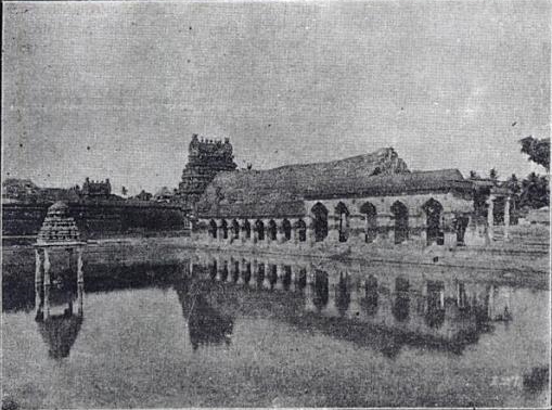
Mayiladuthurai has several ancient temples such as Mayuranathaswami Temple, a prominent Shaivite shrine and Parimala Renganathar Temple, a Vaishnavite shrine which are located in the city.
The Mayuranathaswami Temple complex was built during the time of the Medieval Cholas.[63]
The Punukeeswarar Temple and Aiyaarappar Temple at Koranad, Mayiladuthurai are another important ancient Shiva temples in Mayiladuthurai.[64]
The prominent Vaishnava temples in the town are Parimala Rangnathar Vishnu temple of lord Vishnu at Thiruvilandur on the northern banks of the Cauvery, a Divya desam and a Pancha rangam[65] and Kolikutti Vanamutti Perumal temple.
Other important festivals celebrated at the temple are Navarathri, Adi Pooram, Avani Moolam, Karthigai Deepam and Vaikashi Brahmavotsavam[63] An yearly dance festival called the Mayura Natyanjali is conducted within the precincts of the Mayuranathaswami Temple by the Saptasvarangal Trust during Maha Shivaratri on the pattern of the Chidambaram Natyanjali festival.[66][67]
Tourist attractions
Tharangambadi, Pichavaram mangrove forest, Tirumullaivasal, Palaiyar and Karaikkal are the most prominent tourist attractions located around the town.[68]
Notes
- "Mayiladuthurai Announced As 38th District Of Tamil Nadu". dtNext.in. 28 December 2020. Retrieved 31 December 2020.
- Ayyar 1920, p 271
- Archaeological Survey of India 1969, p. 23
- T. S. Subramanian (1 May 2006). "Significance of Mayiladuthurai find". The Hindu. Chennai, India. Archived from the original on 17 June 2006. Retrieved 17 May 2014.
- T. S. Subramanian (27 April 2008). "Megalithic pottery found". The Hindu. Chennai, India. Archived from the original on 30 April 2008. Retrieved 17 May 2014.
- Swami 1939, p. 317
- Aiyangar 1919, p. 324
- Trivedi 1971, p. 53
- S. S. 1996, p. 125
- "Historical Moments: History of Mayuram". Mayiladuthurai Municipality. 2011. Retrieved 17 May 2014.
- "Nagapattinam District Home Page". Government of India. 2011. Retrieved 17 May 2014.
- D. Vincent Arockiaraj (28 December 2020). "Edappadi K Palaniswami: Tamil Nadu CM Edappadi K Palaniswami inaugurates newly created Mayiladuthurai district | Chennai News - Times of India". The Times of India. Retrieved 30 December 2020.
- K. 1974
- "Maps, Weather, and Airports for Madurai, India". Falling Rain Genomics, Inc. Retrieved 17 May 2014.
- "Chairman of Mayiladuthurai". Mayiladuthurai Municipality, Government of Tamil Nadu. 2012. Retrieved 1 January 2014.
- "Commissioner of Mayiladuthurai". Mayiladuthurai Municipality, Government of Tamil Nadu. 2012. Retrieved 1 January 2014.
- "Vice Chairman of Mayiladuthurai". Mayiladuthurai Municipality, Government of Tamil Nadu. 2012. Retrieved 1 January 2014.
- "MLA of Mayiladuthurai". Government of Tamil Nadu. 2012. Archived from the original on 6 October 2013. Retrieved 1 January 2014.
- "Members of Lok Sabha from Tamil Nadu". Government of Tamil Nadu. 2014. Retrieved 26 May 2014.
- "About Us". Mayiladuthurai Municipality. 2011. Retrieved 17 May 2014.
- Hemingway, p. 213
- "Commissionerate of Municipal Administration". Commissionerate of Municipal Administration. Archived from the original on 6 November 2012. Retrieved 1 January 2014.
- "Councillors of municipality". Mayiladuthurai municipality. 2011. Retrieved 1 January 2014.
- Economic and political weekly 1995, p. 2396
- "General Information". Mayiladuthurai Municipality. 2011. Retrieved 17 May 2014.
- "Budget 2010–11" (PDF) (in Tamil). Mayiladuthurai Municipality. Retrieved 1 January 2014.
- "Tamil Nadu Legislative Assembly Constituency map". Tamil Nadu Legislative Assembly. Archived from the original on 14 June 2012. Retrieved 17 May 2014.
- "Key highlights of the general elections 1962 to the Third Lok Sabha" (PDF). Election Commission of India. p. 49. Retrieved 16 April 2011.
- "Key highlights of the general elections 1980 to the Seventh Lok Sabha" (PDF). Election Commission of India. p. 79. Archived from the original (PDF) on 18 July 2014. Retrieved 26 June 2012.
- "Water supply". Mayiladuthurai Municipality. 2011. Retrieved 17 May 2014.
- "Solid waste management". Mayiladuthurai Municipality. 2011. Retrieved 17 May 2014.
- Urban Infrastructure Report 2008, pp. 8-9
- "Storm water drainage". Mayiladuthurai Municipality. 2011. Retrieved 17 May 2014.
- "Mayiladuthurai hospitals". Mayiladuthurai municipality, Government of Tamil Nadu. 2011. Retrieved 1 January 2014.
- "Street lights in Mayiladuthurai". Mayiladuthurai Municipality, Government of Tamil Nadu. 2011. Retrieved 1 January 2014.
- "Mayiladuthurai Markets". Mayiladuthurai Municipality, Government of Tamil Nadu. 2011. Retrieved 1 January 2014.
- Census of India, 1931, p. 24
- Census of India, 1991, p. 548
- "Census Info 2011 Final population totals - Mayiladuthurai". Office of The Registrar General and Census Commissioner, Ministry of Home Affairs, Government of India. 2013. Archived from the original on 24 September 2015. Retrieved 26 January 2014.
- "Census Info 2011 Final population totals". Office of The Registrar General and Census Commissioner, Ministry of Home Affairs, Government of India. 2013. Retrieved 26 January 2014.
- Urban Infrastructure Report 2007, p. 3
- Urban Infrastructure Report 2007, p. 5
- Urban Infrastructure Report 2007, p. v
- "Mayiladuthurai: Mani means business". India Today. 16 (7–12). 1991.
- "Population By Religious Community - Tamil Nadu" (XLS). Office of The Registrar General and Census Commissioner, Ministry of Home Affairs, Government of India. 2011. Retrieved 13 September 2015.
- "Industry". Mayiladuthurai Municipality. 2011. Retrieved 17 May 2014.
- South Indian Railway Co. Ltd. 1926, p. 52
- W., p. 160
- "Markets and commercial complexes". Mayiladuthurai Municipality. 2011. Retrieved 17 May 2014.
- "Banks and ATM Centres". Mayiladuthurai Municipality. 2011. Retrieved 17 May 2014.
- Church Missionary Society 1825, p. 79
- "Schools in Mayiladuthurai". Mayiladuthurai Municipality. 2011. Retrieved 17 May 2014.
- Commonwealth universities yearbook 2003, p. 737
- Gupta 2006, p. 123
- Urban Infrastructure Report 2007, p. 9
- "How to reach". Mayiladuthurai Municipality. 2011. Retrieved 17 May 2014.
- "Bus Stand". Mayiladuthurai Municipality. 2011. Retrieved 17 May 2014.
- Urban Infrastructure Report 2007, p. 10
- "Tamil Nadu State Transport Corporation (KUM DIV-I) Ltd., Kumbakonam". Government of Tamil Nadu. Retrieved 17 May 2014.
- "Train availability at stations". Indian Railways. 2012. Retrieved 16 November 2012.
- "Passenger trains to be run on Mayiladuthurai-Tiruvarur line". The Hindu. Tiruchi. 11 May 2013. Retrieved 20 May 2014.
- "Passenger trains to Mayiladuthurai, Katpadi, flagged off at Villupuram". The Hindu. Villupuram. 30 March 2013. Retrieved 20 May 2014.
- "Sri Mayuranathar temple". Dinamalar. Retrieved 16 April 2011.
- "Places of Interest". Mayiladuthurai Municipality. 2011. Archived from the original on 20 September 2012. Retrieved 17 May 2014.
- Ayyar 1920, p 281
- "Mayura Natyanjali". Saptasvarangal Trust. Retrieved 17 May 2014.
- "Brilliant show by Chennai dance school students". The Hindu. Chennai, India. 4 May 2009. Archived from the original on 9 March 2009. Retrieved 17 May 2014.
- "Places of tourists". Mayiladuthurai Municipality. 2011. Retrieved 17 May 2014.
References
- Knapp, Stephen (2011). Spiritual India Handbook. Mumbai: Jaico Books. ISBN 978-81-8495-024-3.
- Gupta, Ameeta; Kumar, Ashish; Kumar, Ashish (2006). Handbook of Universities, Volume I. Atlantic Publishers & Dist. p. 123. ISBN 9788126906079.
- Commonwealth universities yearbook, Volume 1. Association of Commonwealth Universities. 2003. p. 737.
- Church Missionary Society (1825). Missionary register, Volume 13. Seeley, Jackson, & Halliday.
- W., Francis. Gazetteer of South India. p. 160.
- Illustrated guide to the South Indian Railway (Incorporated in England): including the Tanjore District Board, Pondicherry, Peralam-Karaikkal, Travancore State, Cochin State, Coimbatore District Board, Tinnevelly-Tiruchendur, and the Nilgiri Railways. South Indian Railway Co. Ltd. 1926.
- Census of India, 1931, Volume 1, Part 2. Manager of Publications. 1933. p. 24.
- Census of India, 1991: B Series. Economic tables. v. 1-2, v. 2 pt. 2, v. 3, pt. 1-2. Manager, Govt. of India Photolitho Press. p. 548.
- Krishna, Nanditha (2002). Sacred tanks of South India. C.P.R. Environmental Education Centre.
- K., Chockalingam (1974). Census of India, 1971 D: Migration Tables. Manager of Publications.
- S. S., Shashi (1996). Encyclopaedia Indica: India, Pakistan, Bangladesh, Volume 100. Anmol Publications. ISBN 9788170418597.
- Trivedi, Krishnaji (1971). Mahatmas: acharyas, mystics, saints, sages, seers. Shivaji News Printers.
- Aiyangar, S. Krishnaswami (1919). Sources of Vijayanagar history. University of Madras. p. 324.
- Swami, Sadananda (1939). Origin and early history of Śaivism in South India. University of Madras. p. 317.
- Indian archaeology: a review (PDF). Archaeological Survey of India. 1969.
- Hemingway, F. R. Madras District Gazetteers: Tanjore. p. 213.
- The Imperial Gazetteer of India 1908, Vol 17. Clarendon Press. 1908. pp. 237–238.
- Debates, Official Report, Volume 89. Tamil Nadu Legislative Council. 1971.
- P. V. Jagadisa Ayyar (1920). South Indian shrines: illustrated. Madras Times Printing and Pub. Co.
- Conversion of City Corporate Plan into Business Plan (PDF) (Report). Tamil Nadu Urban Infrastructure Financial Services Limited. 2007.
Places adjacent to Mayiladuthurai | ||||||||||||||||
|---|---|---|---|---|---|---|---|---|---|---|---|---|---|---|---|---|
| ||||||||||||||||
| District Headquarters |
|  |
|---|---|---|
| Country |
| |
| State | ||
| Region |
| |
| Taluks |
| |
| Revenue blocks |
| |
| Municipalities | ||
| Rivers |
| |
| History |
| |
| Places of interest |
| |
| ||
External links
На других языках
[de] Mayiladuthurai
Mayiladuthurai (Tamil: மயிலாடுதுறை Mayilāṭutuṟai [.mw-parser-output .IPA a{text-decoration:none}ˈmajilaːɖɯd̪urɛi]), früher Mayuram (மாயூரம் Māyūram [ˈmaːjuːɾʌm]) oder Mayavaram (மாயவரம் Māyavram [ˈmaːjəʋaɾʌm]), ist eine Stadt im südindischen Bundesstaat Tamil Nadu. Die Einwohnerzahl beträgt rund 86.000 (Volkszählung 2011). Mayiladuthurai ist Verwaltungssitz des Distrikts Mayiladuthurai.- [en] Mayiladuthurai
Другой контент может иметь иную лицензию. Перед использованием материалов сайта WikiSort.org внимательно изучите правила лицензирования конкретных элементов наполнения сайта.
WikiSort.org - проект по пересортировке и дополнению контента Википедии